Arable land

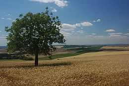
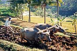
Arable land (from Latin arabilis, "able to be plowed") is land capable of being ploughed and used to grow crops.[1] In Britain, it was traditionally contrasted with pasturable lands such as heaths which could be used for sheep-rearing but not farmland.
In modern agriculture, however, as at the Food and Agriculture Organization,[2] Eurostat,[3][4] and the World Bank,[5] "arable land" is a term of art meaning land that is actually being farmed (at minimum every five years) with crops that are sown and harvested within the same agricultural year. Arable land actually under crops in the present year is known as sown land or cropped land. The amended definition is preferred by the agencies because it distinguishes cultivable land that could be used to raise such annual crops but is instead devoted to "permanent cropland": for example, vinyards, orchards, and farms and plantations growing coffee, rubber, or nuts.[6][7]
[8]==Arable land area== Although constrained by land mass and topography, the amount of arable land, both regionally and globally, fluctuates due to human and climatic factors such as irrigation, deforestation, desertification, terracing, land reclamation and urban sprawl.[9] In 2008, the world's arable land amounted to 1,386 M ha, out of a total 4,883 M ha land used for agriculture.[10]
|
 World map of arable land, percentage by country[12] |
Non-arable land
Land which is unsuitable for arable farming usually has at least one of the following deficiencies: no source of fresh water; too hot (desert); too cold (Arctic); too rocky; too mountainous; too salty; too rainy; too snowy; too polluted; or too nutrient poor. Clouds may block the sunlight plants need for photosynthesis, reducing productivity. Starvation and nomadism often exists on marginally arable land. Non-arable land is sometimes called wasteland, badlands, worthless or no man's land.
However, non-arable land can sometimes be converted into arable land. New arable land makes more food, and can reduce starvation. This outcome also makes a country more self-sufficient and politically independent, because food importation is reduced. Making non-arable land arable often involves digging new irrigation canals and new wells, aqueducts, desalination plants, planting trees for shade in the desert, hydroponics, fertilizer, nitrogen fertilizer, pesticides, reverse osmosis water processors, PET film insulation or other insulation against heat and cold, digging ditches and hills for protection against the wind, and greenhouses with internal light and heat for protection against the cold outside and to provide light in cloudy areas. This process is often extremely expensive. An alternative is the Seawater Greenhouse which desalinates water through evaporation and condensation using solar energy as the only energy input. This technology is optimized to grow crops on desert land close to the sea.
Some examples of infertile non-arable land being turned into fertile arable land are:
- Aran Islands: These islands off the west coast of Ireland, (not to be confused with the Isle of Arran in Scotland's Firth of Clyde), were unsuitable for arable farming because they were too rocky. The people covered the islands with a shallow layer of seaweed and sand from the ocean. This made it arable. Today, crops are grown there.
- Israel: Israel's land primarily consisted of desert until the construction of desalination plants along the country's coast. The desalination plants, which remove the salt from ocean water, have created a new source of water for farming, drinking, and washing.
- Slash and burn agriculture uses nutrients in wood ash, but these expire within a few years.
- Terra preta, fertile tropical soils created by adding charcoal.
Some examples of fertile arable land being turned into infertile land are:
- Droughts like the 'dust bowl' of the Great Depression in the U.S. turned farmland into desert.
- Rainforest Deforestation: The fertile tropical forests are converted into infertile desert land. For example, Madagascar's central highland plateau has become virtually totally barren (about ten percent of the country), as a result of slash-and-burn deforestation, an element of shifting cultivation practiced by many natives.
- Each year, arable land is lost due to desertification and human-induced erosion. Improper irrigation of farm land can wick the sodium, calcium, and magnesium from the soil and water to the surface. This process steadily concentrates salt in the root zone, decreasing productivity for crops that are not salt-tolerant.
See also
- Soil fertility
- Land use statistics by country
- List of environment topics
References
- ↑ Oxford English Dictionary, 3rd ed. "arable, adj. and n." Oxford University Press (Oxford), 2013.
- ↑ "FAOSTAT - Concepts & definitions - Glossary (list)". FAO. Retrieved 2 November 2013.
- ↑ "Glossary: Arable land - Statistics explained". Eurostat. Retrieved 2 November 2013.
- ↑ "Agriculture statistics at regional level". Eurostat. Retrieved 2 November 2013.
Eurostat has followed the FAO's recommendation on the worldwide decennial agricultural census since the 1970 round
- ↑ "Agriculture & Rural Development". The World Bank. Retrieved 2 November 2013.
- ↑ "Glossary: Permanent Crops - Statitics explained". Eurostat. Retrieved 2 November 2013.
- ↑ "The World Factbook, Field Listing: Land use". Central Intelligence Agency. Retrieved 2 November 2013.
- ↑ http://www.lexigram.gr/lex/newg/%CE%B1%CF%81%CF%8C%CF%83%CE%B9%CE%BC%CE%BF#Hist0
- ↑ 9.0 9.1 "Arable Land Area". The Helgi Library. Retrieved 22 February 2014.
- ↑ "FAO Statistical Yearbook - Land use" (EXCEL). FAOSTAT. p. A4. Retrieved 2 November 2013.
- ↑ "FAOSTAT Land Use module". Food and Agriculture Organization. Retrieved 22 February 2014.
- ↑ "The CIA World Factbook". Central Intelligence Agency. Retrieved June 2006.
Percentage shares of total land area [by country] used for arable land - land cultivated for crops like wheat, maize, and rice that are replanted after each harvest
External links
- Surface area of the Earth
- Article from Technorati on Shrinking Arable Farmland in the world
| |||||||||||||||||||||||||||||||||||||||||||||||||||||||
| ||||||||||||||||||||||||||||||||||||||