Araçatuba
| Araçatuba | |||
|---|---|---|---|
 | |||
| |||
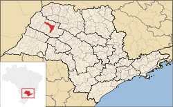
 Location of Araçatuba | |||
| Coordinates: 21°12′32″S 50°25′58″W / 21.20889°S 50.43278°WCoordinates: 21°12′32″S 50°25′58″W / 21.20889°S 50.43278°W | |||
| Country |
| ||
| Region | Southeast | ||
| State |
| ||
| Founded | 1908 | ||
| City status | 1921 | ||
| Government | |||
| • Mayor | Aparecido Sério da Silva | ||
| Area | |||
| • Total | 1,167.4 km2 (450.7 sq mi) | ||
| Elevation | 390 m (1,280 ft) | ||
| Population (2013)[1] | |||
| • Total | 190,536 | ||
| • Density | 160/km2 (420/sq mi) | ||
| Time zone | UTC-3 (UTC-3) | ||
| • Summer (DST) | UTC-2 (UTC-2) | ||
| Postal code | 16015 | ||
| Area code(s) | (+55) 18 | ||
| HDI (2000) | 0,848 – high | ||
| Website | Prefecture of Araçatuba | ||
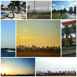
Araçatuba is a city located in the northwest of São Paulo state, Brazil. The city has 190.536 inhabitants (IBGE/2013) and 1,167.4 km² of area.[1] The city name comes from the Tupi language and means "abundance of araçá (a fruit, Psidium cattleianum)". Araçatuba is located 532 km from the city of São Paulo and 11 km from Birigui.
History
Araçatuba was founded in December 2, 1908 and officially established as a municipality in December 8, 1921.[2]
Economy
The Tertiary sector is the most relevant for Araçatuba, corresponding to 79,35% of the city GDP. The Primary sector corresponds to 1.68% of the GDP and the Industry corresponds to 18.97%.[3] Agro-industrial activities are relevant in the region.
Culture
The city is the seat of the mor religiones.
Microregion of Araçatuba
Araçatuba is the center of a Microregion with a population of 256,560 inhabitants (IBGE/2010) an area of 5,365.6 km².[4] This region includes the cities of Bento de Abreu, Guararapes, Lavinia, Rubiácea, Coroados, Santo Antônio do Aracanguá and Valparaíso.
Transportation
- SP-300 Rodovia Marechal Cândido Rondon
- SP-463 Rodovia Elyeser Magalhães
The city is served by the "Dario Guarita Airport".
References
- ↑ 1.0 1.1 "Population at "Censo 2013"" (PDF) (in Portuguese). IBGE.gov.br. Retrieved September 9, 2013.
- ↑ "History of the City". Museumarechalrondon.blogspot.com. Retrieved 29 July 2011.
- ↑ "Municipal Profile at SEADE - Search". SEADE.gov.br. Retrieved 28 July 2011.
- ↑ "2010 Census of the IBGE - Synopsis - Tables 761 and 1301 - Search" (in Portuguese). IBGE.gov.br. Retrieved 28 July 2011.
External links
- (Portuguese) Folha da Região newspaper
- (Portuguese) O Liberal Regional newspaper
Photo gallery


| ||||||||||||||||||||||||||||||||||||||||||||||||||||||||||||

