Apoyeque
| Apoyeque | |
|---|---|
 Map of Nicaragua, showing location of Chiltepe peninsula and Nicaragua volcanic front. | |
| Elevation | 518 m (1,699 ft) |
| Location | |
| Location | Nicaragua |
| Coordinates | 12°14′30″N 86°20′30″W / 12.24167°N 86.34167°W |
| Geology | |
| Type | Pyroclastic shield |
| Last eruption | 50 BC ± 100 years |
Apoyeque is a pyroclastic shield, located in the Chiltepe Peninsula Natural Reserve in Nicaragua. It has a 2.8-km wide, 400-m-deep, lake-filled caldera.[1]
Geography
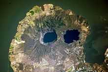
Apoyeque is a volcanic complex that formed and occuplies the Chiltepe Peninsula. It is part of the Chiltepe pyroclastic shield volcano, one of three ignimbrite shields on the Nicaraguan volcanic front.[2]
The lake at its center, Apoyeque lake (Spanish: Laguna de Apoyeque, also called Laguna de Apoyaque, [3]), its shore 100 meters below the peak of the caldera, at its bottom reaches down to sea level.
Apoyeque, as well as the entire Chiltepe peninsula are part of the Managua administrative region, in close proximity to city of Managua, Nicaragua's capital.[4]
Immediately Southeast of Apoyeque peak is the 2.5 x 3 kilometer wide lake-filled Xiloá (Jiloá) maar, a part of the Apoyeque complex.
Volcanology
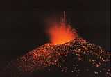
Apoyeque, with a volcanic explosivity index (VEI) of 6, had one of the largest explosions known in history,[5] last erupted in about 50 BC.
In addition to the Chiltepe dome (volcán Chiltepe), which is used synonymously with Apoyeque, the Apoyeque complex contains the Jiloa caldera (Laguna de Jiloa[6] aka Xiloá), the Miraflores dome and the Cerro Talpetate dome.[7]
An eruption of Laguna Xiloá 6100 years ago produced pumiceous pyroclastic flows that overlay similar deposits of similar age from Masaya.[8]
See also
References
- ↑ "Apoyeque Volcano, Global Volcanism Program, Smithsonian National Museum of Natural History". Retrieved 2010-08-02..
- ↑ "Apoyeque Volcano, Nicaragua in geographic.org". Retrieved 2010-08-02..
- ↑ "Laguna de Apoyaque: Nicaragua, geographic.org". Retrieved 2010-08-02..
- ↑ "Laguna de Apoyegue: Nicaragua, geographic.org". Retrieved 2010-08-02..
- ↑ "Large volcano explocivity index rankings". Archived from the original on 7 July 2010. Retrieved 2010-08-02..
- ↑ "Laguna de Jiloá: Nicaragua". Retrieved 2010-08-02.
- ↑ "Volcano Names with Synonyms and Subfeatures". Retrieved 2010-08-02.
- ↑ "Apoyeque Summary, in Smithsonian National Museum of Natural History's Global Volcanism Program". Retrieved 2010-08-02.
| |||||||||||||||||||||||||||||