Apia
| Apia Ah-Pee-Ah | |
|---|---|
|
View of the Samoan government buildings in Apia | |
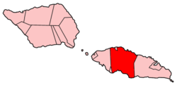
 Map of Apia | |
 Apia Map of Apia | |
| Coordinates: 13°50′S 171°45′W / 13.833°S 171.750°WCoordinates: 13°50′S 171°45′W / 13.833°S 171.750°W | |
| Country |
|
| District | Tuamasaga |
| Constituency | Vaimauga West and Faleata East |
| Founded | 1850s |
| Became Capital | 1959 |
| Area | |
| • Urban | 20.0 sq mi (51.8 km2) |
| Elevation[1] | 7 ft (2 m) |
| Population (2006) | |
| • Urban | 37,708 |
| • Urban density | 2,534.48/sq mi (6,534.27/km2) |
| Time zone | UTC+13:00 (UTC+13) |
| • Summer (DST) | UTC+14:00 (UTC+14) |

Apia is the capital and the largest city of Samoa. From 1900 to 1919, it was the capital of the German Samoa. The city is located on the central north coast of Upolu, Samoa's second largest island. Apia is the only "city" in Samoa and falls within the political district (itūmālō) of Tuamasaga.
The Apia Urban Area has a population of 37,708 (2006 Census)[2] and is generally referred to as the City of Apia. The geographic boundaries of Apia Urban Area is mainly from Letogo village to the new industrialized region of Apia known as Vaitele.
History
Apia was originally a small village (the 1800 population was 304[2]), from which the country's capital took its name. Apia village still exists within the larger modern capital of Apia which has grown into a sprawling urban area with many villages. Like every other settlement in the country, Apia village has its own matai chiefly leaders and fa'alupega (geneaology & customary greetings) according to fa'a Samoa.
The modern capital Apia was founded in the 1850s and has been the official capital of Samoa since 1959.[3]
The harbor was also the site of an infamous 15 March 1889 naval standoff in which seven ships from Germany, the US, and Britain refused to leave harbor while a typhoon was clearly approaching, lest the first moved would lose face. All the ships were sunk, except the British cruiser Calliope, which barely managed to leave port at 1 mile per hour and ride out the storm. Nearly 200 American and German lives were lost, as well as six ships sunk or beyond repair.[4]
During the country's struggle for political independence in the early 1900s, organised under the national Mau movement, the streets of Apia became the center of non-violent protests and marches where many Samoans were arrested. In what became known as "Black Saturday", a peaceful Mau gathering in the town resulted in the killing of paramount chief Tupua Tamasese Lealofi III by New Zealand constabulary on 28 December 1929.[5]
Geography

Apia is situated on a natural harbour at the mouth of the Vaisigano River. It is on a narrow coastal plain with Mount Vaea (elevation 472 m), the burial place of writer Robert Louis Stevenson, directly to its south. Two main ridges run south on either side of the Vaisigano River, with roads on each. The more western of these is Cross Island Road, one of the few roads cutting north to south across the middle of the island to the south coast of Upolu.
Climate
Apia features a tropical rainforest climate with consistent temperatures throughout the year. Apia's driest months are July and August when on average about 80 mm of rain falls. Its wettest months are December through March when average monthly precipitation easily exceeds 300 mm. Apia's average temperature for the year is 26 degrees Celsius.
| Climate data for Apia, Samoa | |||||||||||||
|---|---|---|---|---|---|---|---|---|---|---|---|---|---|
| Month | Jan | Feb | Mar | Apr | May | Jun | Jul | Aug | Sep | Oct | Nov | Dec | Year |
| Average high °C (°F) | 30 (86) |
29 (84) |
30 (86) |
30 (86) |
29 (84) |
29 (84) |
29 (84) |
28 (82) |
28 (82) |
29 (84) |
30 (86) |
29 (84) |
29 (84) |
| Average low °C (°F) | 23 (73) |
24 (75) |
23 (73) |
23 (73) |
23 (73) |
23 (73) |
23 (73) |
23 (73) |
23 (73) |
23 (73) |
23 (73) |
23 (73) |
23 (73) |
| Average precipitation mm (inches) | 450 (17.72) |
380 (14.96) |
350 (13.78) |
250 (9.84) |
160 (6.3) |
120 (4.72) |
80 (3.15) |
80 (3.15) |
130 (5.12) |
170 (6.69) |
260 (10.24) |
370 (14.57) |
2,850 (112.2) |
| Avg. precipitation days (≥ 0.1 mm) | 19 | 18 | 17 | 15 | 13 | 11 | 8 | 9 | 12 | 14 | 16 | 17 | 173 |
| Source: http://www.weatherbase.com/weather/weather.php3?s=26719&refer=&units=metric'' | |||||||||||||
| Apia | ||||||||||||||||||||||||||||||||||||||||||||||||||||||||||||
|---|---|---|---|---|---|---|---|---|---|---|---|---|---|---|---|---|---|---|---|---|---|---|---|---|---|---|---|---|---|---|---|---|---|---|---|---|---|---|---|---|---|---|---|---|---|---|---|---|---|---|---|---|---|---|---|---|---|---|---|---|
| Climate chart (explanation) | ||||||||||||||||||||||||||||||||||||||||||||||||||||||||||||
| ||||||||||||||||||||||||||||||||||||||||||||||||||||||||||||
| ||||||||||||||||||||||||||||||||||||||||||||||||||||||||||||
Administration

Apia is part of the Tuamasaga political district and of election district Vaimauga West and Faleata East. There is no city administration for Apia. Apia consists of some 45 individual, independent villages. Apia proper is just a small village between the mouths of the Vaisigano (east) and Mulivai (west) rivers, and is framed by Vaisigano and Mulivai villages, together constituting "Downtown Apia".
The Planning Urban Management Authority (PUMA) Act 2004[6] (amended in 2005[7]) was passed by parliament to better plan for the urban growth of Samoa's built-up areas, with particular reference to the future urban management of Apia. The city's historical haphazard growth from village to colonial trading post to the major financial and business centre of the country has resulted in major infrastructural problems in the city. Problems of flooding are commonplace in the wet season, given the low flood-prone valley that the city is built on. In the inner-city village of Sogi, there are major shoreline pollution and effluent issues given that the village is situated on swamplands. The disparate village administrations of Apia has resulted in a lack of a unified and codified legislative approach to sewerage disposal. The relatively high growth in vehicle ownership has resulted in traffic congestion in the inner city streets and the need for major projects in road-widening and traffic management. The PUMA legislation sets up the Planning Urban Management Authority to better manage the unique planning issues facing Apia's urban growth.
City features

Mulinu'u, the old ceremonial capital, lies at the city's western end, and is the location of the Parliament House (Maota Fono) and the historic observatory, which is now the meteorology office.
The name of the Catholic Cathedral in Apia is the Immaculate Conception of Mary Cathedral but as of mid-2011 the old cathedral had been demolished, reportedly due to structural damage from the large earthquake in September 2009, with a new one being built.
An area of reclaimed land jutting into the harbour is the site of the Fiame Mataafa Faumuina Mulinuu II (FMFM II) building, the multistorey government offices named after the first Prime Minister of Samoa, and the Central Bank of Samoa. A clock tower erected as a war memorial acts as a central point for the city. The new market (maketi fou) is inland at Fugalei, where it is more protected from the effects of cyclones. Apia still has some of the early, wooden, colonial buildings which remain scattered around the town, most notably the old courthouse (the new courthouse now operating in Mulinu'u), with a museum on the upper floor. Recent infrastructural development and economic growth has seen several multi-story buildings being built in the city. The ACC building (2001) houses the Accident Compensation Board, the National Bank of Samoa, and some government departments. The mall below it is home to shops and eateries. The Samoatel building (2004) which is the site for Samoa's international telecommunications hub was built inland at Maluafou, again to protect it from the effects of seasonal cyclones. The DBS building (2007) in Savalalo houses the Development Bank of Samoa and new Courts complex in Mulinuu housing the district, supreme, and land & titles courts (2010). The Tui Atua Tupua Tamasese Building (2012) in Sogi, houses government ministries. Newer additions to Apia's skyline is the SNPF Molesi shopping mall is due to open in 2013, as is the new hospital at Motootua.
Writer Robert Louis Stevenson spent the last four years of his life here, and is buried on Mt. Vaea, overlooking both the city and the home he built, Vailima, which is now a museum in his honour.
Economy
Polynesian Airlines and Virgin Samoa has its headquarters in the Samoa National Provident Fund Building in Apia.[8]
Transport

Apia Harbour is by far the largest and busiest harbour in Samoa. International shipping with containers, LPG gas, and fuels all dock here. Ferries to Tokelau and American Samoa depart from here.
Apia is served by a good road network, which is generally kept reasonably well maintained. Most of the main roads are sealed; the unsealed roads have lower use. Vehicles drive on the left-hand side of the road since 7 September 2009.[9]
The Samoan government started the second phase of a major upgrading of arterial routes around the Apia Urban Area in 2012, with incremental widening of major roads around the city.[10]
The country has no trains or trams, but is served with an extensive and privatised bus and taxi system. People commonly walk around the town, or even for some distances outside it. There are few bicycles and motorcycles, but traffic congestion due to a huge increase in vehicle ownership has necessitated a major upgrade in road infrastructure.[11]
Fagali'i Airport, the small airstrip in Fagali'i, which was used for internal flights and some international flights to Pago Pago in American Samoa has now been reopened.[12] The main international airport, Faleolo International Airport, is a 40-minute drive west of the city. Samoa's major domestic airlines, Polynesian Airlines and Samoa Air, service this airport.
Communications
Telephone services are efficient with local, trunk and international dialing. Both BlueSky SamoaTel and Digicel operate mobile phone services with a high rate of mobile phone ownership in the country. Broadband internet services are available at various wifi hotspots around the city.
International internet services are served by fibre-optic cable (in service since May 2009[13]) with a backup satellite link.
Education
Apia is home to a number of pre-schools, primary, secondary and post-secondary institutions,[14] including Samoa's only university, the National University of Samoa. In addition, the University of the South Pacific School of Agriculture maintains a campus[15] at Alafua, on the outskirts of Apia.
Universities
- National University of Samoa
- University of the South Pacific
- Oceania University of Medicine
Colleges
- Avele College, Avele
- Church College of Samoa, Pesega
- Faatuatua Christian College, Vaitele Fou
- Leififi College, Leififi
- Leulumoega-fou College, Malua
- Malua Theological College
- Maluafou College, Maluafou
- Saint Joseph's College, Alafua
- Assemblies of God Harvest Bible College, Lotopa
- Saint Mary's College, Vaimoso
- Samoa College, Vaivase Tai
- Fia Malamalama-i-Siulapa College (This is for special needs students)
- Samoa Adventist College, Lalovaea
- Robert Louis Stevenson College, Tafaigata
- Wesley College, Faleula
- Nuuausala College
- Paul Six College
- Chanel College, Moamoa
Primary schools
Most of the Villages have their own primary schools but the Churches run most of the primary schools in Downtown Apia.
- Marist Brother's School, Mulivai
- Saint Mary's School, Savalalo
- Peace Chaapel School, Vaimea
- Apia Baptist School, Aai o Niue
- Seventh-day Adventist Primary School, Lalovaea
Sport
Pacific Games
Apia hosted the Pacific Games in 1983 for the first time in both the city and the country's history. The Games returned to Apia for the 2007 Pacific Games, in which Samoa finished third. A crowd of 20,000 attended the 2007 Games closing ceremony, which took place at Apia Park.
Association football
Apia hosted the Oceania region's qualification matches for the 2010 FIFA World Cup. As such, Apia was the location of the first goal scored in the 2010 qualifiers, by Pierre Wajoka of New Caledonia against Tahiti.[16] The qualification matches commenced on 27 August 2007 and finished on 7 September 2007.[17] All matches were played at the Toleafoa J.S. Blatter Complex, which is named after FIFA president Sepp Blatter.
The complex, based in Apia, is also the venue of the Samoa national football team's home matches and has a capacity of 3,500.
Judo
The capital also hosted the 2010 Judo World Cup Olympic Qualifier in November 2010.[18] The competition saw judoka from Canada, Australia, New Zealand and the USA take part.
Cricket
Apia hosted the 2012 ICC World Cricket League Division Eight tournament at the Faleata Oval's, which consists of four cricket grounds. The national teams of Samoa, Belgium, Japan, Suriname, Ghana, Bhutan, Norway and Vanuatu took part. It was the first time a tournament officially sanctioned by the International Cricket Council had been held in the region.[19]
Sister Cities
 Compton, California, United States (2010)[20]
See also
References
- ↑ "Weather Underground: Apia, Samoa".
- ↑ 2.0 2.1 "Population and Housing Census Report 2006" (PDF). Samoa Bureau of Statistics. July 2008. Retrieved 16 December 2009.
- ↑ "Samoa", Encyclopædia Britannica
- ↑ http://www.history.navy.mil/photos/events/ev-1880s/ev-1889/sam-hur.htm
- ↑ http://www.nzhistory.net.nz/politics/samoa/rise-of-mau
- ↑ "Planning and Urban Management Act 2004".
- ↑ "Planning and Urban Management Amendment Act 2005".
- ↑ "Our Company." Polynesian Airlines. Retrieved on 23 October 2009.
- ↑ Chang, Richard S. (8 September 2009). "In Samoa, Drivers Switch to Left Side of the Road". The New York Times.
- ↑ Tavita, Tupuola Terry (2 July 2012). "Convent Street, first phase in capital development". Savali News.
- ↑ Ministry Statement, MNRE (19 November 2008). "Parking Policy Statement" (PDF). Newsline.
- ↑ Sagapolutele, Fili. "Polynesian to resume flying into Fagali’i airport this week". Samoa News. SamoaNews.com. Retrieved 11 June 2011.
- ↑ "ASH/SAS submarine cable announcement." Submarine Networks website. Retrieved on 3 October 2011.
- ↑ Encyclopedia of the Nations: Samoa Education
- ↑ University of South Pacific: Alafua Campus
- ↑ http://m.fifa.com/newscentre/news/newsid=1135945.html
- ↑ http://www.futbolplanet.de/oceania/south_pacific_games/south_pacific_games_2007.htm
- ↑ http://intjudo.eu/News/cikk10908
- ↑ "World Cricket League Division 8, Apia (Samoa), September 2012". www.cricketeurope4.net. Retrieved 17 September 2012.
- ↑ "Sister Cities of Compton". comptonsistercities.org. Retrieved 2013-07-02.
External links
| Wikimedia Commons has media related to Apia. |
- View of Apia, the Capital of Samoa, One of the Islands in the Pacific Ocean, from Harper's Weekly, 12 January 1895 by D.J. Kennedy, the Historical Society of Pennsylvania
| ||||||||||||||||||||||||||||||
| |||||||||||||||||||||||||||||||||