Apaxco
| Apaxco | |||
|---|---|---|---|
| Municipality and town | |||
 | |||
| |||
| Country |
| ||
| State | Mexico (state) | ||
| Area | |||
| • Total | 80.34 km2 (31.02 sq mi) | ||
| Population (2005) | |||
| • Total | 25,738 | ||
| Time zone | Central Standard Time (UTC-6) | ||
| • Summer (DST) | Central Daylight Time (UTC-5) | ||


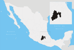
Apaxco de Ocampo is the seat of the municipality of Apaxco located in the northeastern part of the state of Mexico in Mexico, although both are commonly called Apasco. The town is located at a northern pass leading out of the Mezquital Valley and about 128 km northeast of the state capital of Toluca. This name come from Nahuatl and means "place of the water fall".[1]
The municipality was founded on October 16, 1870, this covers an area of 80.34 km². As of 2005, the municipality had a total population of 25,738.
History
The first settlers in the region date back to 5000 BC, evidence of which is the expression carved on the stones of the Cerrado cincunvecinos. It estma that the inhabitants were otomiano group in later years lived in Tollan Xicocotitlan.
The civilizations that inhabited what is now Apaxco had a direct relationship with the Teotihuacan civilization, until they declined to between 650 and 900, after that were dominated by the Toltecs.
In 1215, during the pilgrimage to the mythical promised city of the Aztecs, was the site Apaxco held the second fire again before moving on to the south, towards ending their long journey Ecatepec on the banks of the hill of Chapultepec.
With the rise of the Aztec Empire, Apaxco region and all the neighbors were under the government of Tacuba, one of the members of the Triple Alliance. Apaxco remained in this position until the fall of Tenochtitlan before the army of Hernán Cortés.
In colonial times Apaxco Commit entered the system imposed by the Spanish conquerors, and came under the command of Cristóbal Hernandez Mosquera in 1530.
Apaxco was erected as a township in 1870 after the end of the French intervention, the first school was founded in 1880. But during the Porfirio Díaz government, the municipality entered into a phase of strong economic recession and the town disappeared in 1899 for failing to keep administrative or economically, from that date until 1923 Apaxco was a part from Texquiquiac Township.
References
- ↑ "Apaxco". Enciclopedia de los Municipios de México. Instituto Nacional para el Federalismo y el Desarrollo Municipal. Retrieved June 5, 2009.