Apache Lake (Arizona)
| Apache Lake | |
|---|---|
 | |
| Location | Maricopa / Gila counties, Arizona |
| Coordinates | 33°34′43″N 111°15′48″W / 33.57861°N 111.26333°WCoordinates: 33°34′43″N 111°15′48″W / 33.57861°N 111.26333°W |
| Type | reservoir |
| Primary inflows | Salt River |
| Primary outflows | Salt River |
| Basin countries | United States |
| Surface area | 2,568 acres (1,039 ha) |
| Average depth | 240 ft (73 m) |
| Water volume | 254,138 acre·ft (313,475,000 m3) |
| Surface elevation | 1,900 ft (580 m) |
| Settlements | Tortilla Flat, Arizona |
Apache Lake is one of four reservoirs built along the Salt River in central Arizona as part of the Salt River Project.
Geography
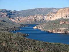
The lake is located near the Apache Trail and town of Tortilla Flat, in Gila County, Arizona. It is about 65 miles (104 km) northeast of Phoenix.
Apache Lake is formed by Horse Mesa Dam impounded the Salt River, which was completed in 1927. The second largest of the four Salt River Project reservoirs, Apache Lake is located about 5 miles (8 km) downstream from Theodore Roosevelt Lake (the largest), and upstream from Canyon Lake and Saguaro Lake.
The surface area of the lake is 2,568 acres (1,039 ha) at full capacity and it can store 254,138 acre·ft (313,475,000 m3) of water.

Recreation
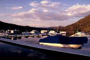
Apache Lake is a popular recreation destination within the Tonto National Forest, which is the authority that manages the facilities located at the lake. The lake is located along the Apache Trail and a number of other hiking trails can be found in the area.
Many species of fish can be found in the lake, including largemouth, smallmouth and yellow bass, crappie, sunfish, both channel and flathead catfish, walleye and carp.
Tonto National Monument, with ancient cliff dwellings, is located 4 miles (6.4 km) south of the reservoir.
See also
References
- Arizona Fishin' Holes, Phoenix, AZ: Arizona Game and Fish Department, 2007
|first1=missing|last1=in Authors list (help)
External links
- Apache Lake Marina
- Daily Water Level report from SRP
- Arizona Boating Locations Facilities Map
- Arizona Fishing Locations Map
- Video of Apache Lake
| Wikimedia Commons has media related to Apache Lake, Arizona. |