Ao Luek District
| Ao Luek อ่าวลึก | |
|---|---|
| Amphoe | |
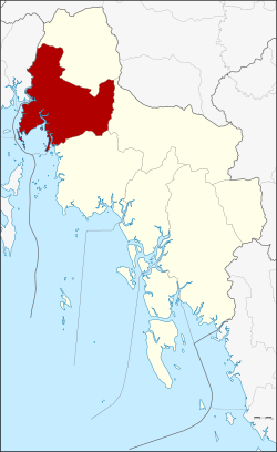 Amphoe location in Krabi Province | |
| Coordinates: 8°22′39″N 98°43′18″E / 8.37750°N 98.72167°ECoordinates: 8°22′39″N 98°43′18″E / 8.37750°N 98.72167°E | |
| Country |
|
| Province | Krabi |
| Area | |
| • Total | 772.989 km2 (298.453 sq mi) |
| Population (2005) | |
| • Total | 48,474 |
| • Density | 62.7/km2 (162/sq mi) |
| Time zone | THA (UTC+7) |
| Postal code | 81110 |
| Geocode | 8105 |
Ao Luek (Thai: อ่าวลึก) is a district (amphoe) in Krabi Province, Thailand.
Geography
Neighboring districts are (from the north clockwise) Plai Phraya, Khao Phanom, Mueang Krabi. To the south west it borders the Phang Nga Bay, to the west is Thap Put of Phang Nga Province.
Than Bok Khorani National Park was established on September 30, 1998 and covers 104 km² of coastal limestone hills and 23 islands off the coast. Within the national park is the skull cave (Tham Hua Kalok), containing prehistoric paintings.
Administration
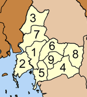
The district is subdivided into 9 sub-districts (tambon), which are further subdivided into 51 villages (muban). There are two townships (thesaban tambon) - Ao Luek Tai covering parts of tambon Ao Luek Tai and Ao Luek Nuea, and Laem Sak covering parts of tambon Laem Sak. Each tambon has a tambon administrative organization (TAO), responsible for the area not belonging to any of the townships.
|
 |