Anti-Lebanon mountains

The Anti-Lebanon mountains is the Western name for the Eastern Lebanon Mountain Range (Arabic: جبال لبنان الشرقية), which are a southwest-northeast-trending mountain range that form the majority of the border between Syria and Lebanon. The border is largely defined along the crest of the range. Most of the range lies in Syria.
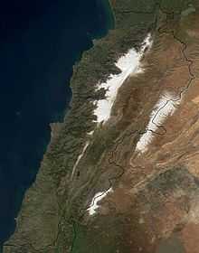
Its Western name (Anti-Lebanon) comes from the Greek Anti-Libanus, in which the prefix "anti" means ‘opposite’. The range lies east of and parallel (opposite) to the Mount Lebanon range. At its southern end it is also within the Golan Heights. To the west lie valleys which separate it from the Lebanon range in central Lebanon - the Beqaa Valley in the north and the Hasbani River valley in the south. To the east, in Syria, lies the Eastern Plateau which contains the city of Damascus.
The Anti-Lebanon range is approximately 150 kilometres (93 miles) in length. To the north, it extends to almost the latitude of the Syrian city of Homs. To the south, the range coalesces with the Golan Heights plateau but includes the highest peaks of Mount Hermon (Jabal el-Shaykh, in Arabic), at 2,814 metres, and Ta'la't Musa, at 2,669 metres. These peaks are snow-covered for much of the year and are located on the Lebanese-Syrian border.
Coordinates: 34°00′N 36°30′E / 34.000°N 36.500°E
References
Further reading
 James, Edward Boucher (1854). "Antilibanus". In Smith, William. Dictionary of Greek and Roman Geography 1. London: John Murray. pp. 140,141.