Antalaha District
Not to be confused with Antalaha, the Malagasy commune with same name.
| Antalaha District | |
|---|---|
| District | |
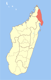
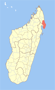 Location in Madagascar | |
| Coordinates: 14°53′S 50°17′E / 14.883°S 50.283°E | |
| Country | Madagascar |
| Region | Sava |
| Area | |
| • Total | 7,085 km2 (2,736 sq mi) |
| Population (2001) | |
| • Total | 186,322 |
| • Density | 26.3/km2 (68/sq mi) |
| • Ethnicities | Betsimisaraka |
| Time zone | EAT (UTC3) |
Antalaha is a district in northern Madagascar. The district contains the Masoala peninsula, and is limited by Antongil Bay in south-west and Indian Ocean on east. It is a part of Sava Region and borders the districts of Sambava in north, Andapa in north-west and Maroantsetra in west. The area is 7,085 km2 (2,736 sq mi) and the population was estimated to be 186,322 in 2001.
The district is divided into 14 communes.
References and notes
Coordinates: 14°53′S 50°17′E / 14.883°S 50.283°E
| ||||||||||||||||||||