Annalong Forest
| Annalong Forest | |
|---|---|
|
Annalong Wood with the Mourne Mountains in the background. | |
| Geography | |
 Location of Annalong Forest | |
| Location | Down, Northern Ireland, United Kingdom |
| Coordinates | 54°08′38″N 5°56′24″W / 54.144°N 5.94°WCoordinates: 54°08′38″N 5°56′24″W / 54.144°N 5.94°W |
| Area | 303.42 hectares (749.8 acres) |
| Governing body | Northern Ireland Water |
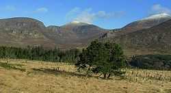
Annalong Forest is located near the village of Annalong in County Down, Northern Ireland. It is made up of two sections, Annalong Wood and Silent Valley. The forest consists of various species of conifer.[1] It is part of the Mourne Area of Outstanding Natural Beauty.[2] There have been two major forest fires in the area in recent years. One, which started on 30 April 2011, required 10 fire engines to extinguish and caused the temporary closure of a number of roads.[3][4] Another, on 24 April 2010, destroyed approximate 50 hectares of gorse and was believed to started deliberately.[5]
References
- ↑ "Annalong Forest". NI Direct. Retrieved 17 December 2014.
- ↑ "Mourne AONB". DOE NI. Retrieved 17 December 2014.
- ↑ "Mourne gorse fires 'deliberate'". UTV. 1 May 2011. Retrieved 17 December 2014.
- ↑ Fergus, Lindsay (2 May 2011). "Fires sweep Northern Ireland countryside". Belfast Telegraph. Retrieved 17 December 2014.
- ↑ "Major Mourne blaze at Annalong Wood tackled". BBC. 24 April 2010. Retrieved 17 December 2014.
| ||||||||||||||||||||||||||||||