Annagh, County Cavan
Annagh is a townland in the Parish of Tomregan, Barony of Tullyhaw, County Cavan, Ireland. On the 1609 Ulster Plantation map it is split into two townlands named Shannaontra and Shannaititr. In an Inquisition dated 20 September 1630 the two townlands were spelled ‘Townaeiateragh’ & “Tawnaowteragh”, but by the Down Survey of 1655 both townlands were merged into one and it is named ‘Annagh alias Tannaghyeitragh alias Tannaghoteragh’. The usual meaning suggested for the place name is that Annagh is an anglicisation of the Irish language placename “Eanach” which means ‘A moor or marsh’. However it is more likely that Annagh is an abbreviation of ‘Tannagh’ (meaning a pasture) as the older names of the place in Irish were ‘Tamnach Íochtar’ & “Tamnach Uachtar” which mean ‘Lower Pasture’ and “Upper Pasture”.
Annagh is one of four townlands over which the town of Ballyconnell extends. It is bounded on the north by the international border with Fermanagh and Northern Ireland, on the east by Cuillaghan, Killywilly, Corranierna and Mullaghduff townlands, on the south by Cullyleenan townland and on the west by Doon, Rakeelan and Gortawee townlands. Its chief geographical features are Annagh Lough, the Dhoogue stream, Scotchtown Island, Monkey’s Island, a chalybeate well, Bray Wood, some drumlin hills reaching an altitude of 200 feet (61 m) above sea-level and the Shannon-Erne Waterway which flows north along the western boundary of the townland. Bray Wood is the finest and most extensive area of woodland along the Shannon-Erne Waterway, consisting principally of Ash and Hazel together with Oak, Elm and Rowan. The undergrowth consists of Holly, Blackthorn and Bramble, with a rich ground flora. Scotchtown Island has a wet woodland flora, dominated by Alder and Salex spp. The original non-canalised Woodford River Channel on the boundary with Cloncoohy contains rich wetland floras.
Annagh is traversed by Bridge Street, Daisy Hill, the Belturbet Road and some demesne lanes.
The townland covers 419 statute acres, including 33 acres (130,000 m2) of water. It formed part of the Manor of Calva which was granted to Walter Talbot in 1610 as part of the Plantation of Ulster. The Hearth Money Rolls of 1664 list the occupiers of Ballyconnell as Thomas Gwyllym, John Squire, Henry Jordan and Denis Alarne, but this would have included both Doon and Annagh townlands as Thomas Gwyllym was the owner of Ballyconnell Castle and lived in Annagh. Griffith's Valuation of 1857 lists only one landholder in Annagh, Dr. George Roe, the owner of Ballyconnell House. Further information and a detailed map showing the location of each holding can be seen online.[1] The 1841 Census of Ireland gives a population of 25 for the townland, of which 9 were males and 16 were females, with 3 houses. The population probably consisted of the family and servants of Ballyconnell House. The 1851 Census of Ireland gives a population of 31, of which 12 were males and 19 were females, with 4 houses, 2 of which were probably the gatehouses of Ballyconnell House. In the 1911 census of Ireland, there are eight families listed in the townland.[2]
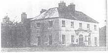
The historic sites in the townland are a medieval crannóg in Annagh Lough (Site number 1469, page 175, Annagh townland, in “Archaeological Inventory of County Cavan”, Patrick O’Donovan, 1995) and Ballyconnell House with its Demesne & external buildings including a sweathouse and gatehouses (Site number 1798, page 228, Annagh townland, in “Archaeological Inventory of County Cavan”, Patrick O’Donovan, 1995). A castle was erected there between 1611 & 1619. Samuel Lewis states in his 1837 ‘Topographical Dictionary of Ireland’ that the house was erected in 1764 by George Montgomery (MP) on the site of Ballyconnell Castle which was entirely destroyed by an accidental fire. However this statement is contradicted by Rev. William Henry’s book “Upper Lough Erne” written in 1739, page 23 of which states ‘Here on the south side of the river, defended by huge old trees, stands a beautiful new seat of the Rev. George Leslie. This seat is of hewn stone without, and elegantly finished with stucco work within. The front is diversified with dark and light-coloured stones, resembling a pavement: It looks to the west; and the river answers to it as a canal.’ So either the new house was burnt down in 1764 and another one erected on its site or Lewis gave an incorrect date and the castle was burnt c.1739 and Ballyconnell House was erected then.
On the right-hand side of the lane heading north-east from Ballyconnell House is a very ancient yew tree (Taxus baccata). It has a massive girth and is reckoned to be well over 2,000 years old, possibly the oldest tree in Europe.