Ankavandra
| Ankavandra | |
|---|---|
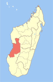
 Ankavandra Location in Madagascar | |
| Coordinates: 18°46′S 45°18′E / 18.767°S 45.300°E | |
| Country |
|
| Region | Menabe |
| District | Miandrivazo |
| Elevation[1] | 134 m (440 ft) |
| Population (2001)[2] | |
| • Total | 11,000 |
| Time zone | EAT (UTC3) |
| Climate | Aw |
Ankavandra is a town and commune (Malagasy: kaominina) in Madagascar. It belongs to the district of Miandrivazo, which is a part of Menabe Region. The population of the commune was estimated to be approximately 11,000 in 2001 commune census.[2]
Ankavandra is served by a local airport. Primary and junior level secondary education are available in town. The majority 50% of the population works in fishing. 25% are farmers, while an additional 20% receives their livelihood from raising livestock. The most important crop is rice, while other important products are sugarcane and cassava. Services provide employment for 5% of the population.[2]
Ankavandra lies on the Manambolo river, and has a population of estimated at 5000
References and notes
- ↑ Estimated based on DEM data from Shuttle Radar Topography Mission
- ↑ 2.0 2.1 2.2 "ILO census data". Cornell University. 2002. Retrieved 2008-03-09.
| ||||||||||||||||||||||||
Coordinates: 18°46′20″S 45°17′35″E / 18.77222°S 45.29306°E