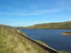
Angram Reservoir
| Angram Reservoir | |
|---|---|
 | |
| Location | Upper Nidderdale, North Yorkshire |
| Coordinates | 54°10′50″N 1°56′22″W / 54.18056°N 1.93944°WCoordinates: 54°10′50″N 1°56′22″W / 54.18056°N 1.93944°W |
| Type | reservoir |
| Primary inflows | River Nidd, Stone Beck |
| Primary outflows | River Nidd |
| Basin countries | United Kingdom |
| Surface area | 34 ha |
| Max. depth | 33.4 m (110 ft) |
| Water volume | 4.75 million cubic metres (1,000 million gallons) |
Angram Reservoir is the first of three reservoirs on the River Nidd in Upper Nidderdale, North Yorkshire, England, the others being Scar House Reservoir and finally the compensation reservoir Gouthwaite Reservoir. It is located at OS map reference SE040759. Between them they attract around 150,000 visitors a year.
The reservoir takes its name from Angram, a settlement in the township of Stonebeck Up, submerged when the reservoir was built.
Little Whernside (604m) to the north and Great Whernside(704m) to the west of the Reservoir are close by.
The River Nidd flows for approximately 3km from the flanks of Great Whernside before joining the reservoir.
The reservoir was built to supply water to the Bradford area of West Yorkshire. The water is transferred to Chellow Heights via the Nidd Aqueduct using gravity only and no pumping.
Two bypass channels on each side of the reservoir were used to bypass the reservoir and maintain the level of the River Nidd. Once Scar House Reservoir was constructed, these become obsolete, but control machinery can still be seen on the Nidd and Stone beck inlets.
| Completed | 1919 |
| Dam height | 61m / 200ft |
Facilities
There is a shelter near the dam, but no other facilities. Near the dam of Scar House Reservoir, 2 km from the dam of Angram Reservoir, there is a car park, picnic areas and toilets.
There is a footpath across the dam and around the reservoir.[1] There is no fishing at the reservoir.[2]
References
External links
![]() Media related to Angram Reservoir at Wikimedia Commons
Media related to Angram Reservoir at Wikimedia Commons