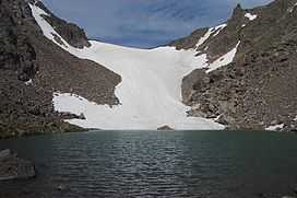
Andrews Glacier
| Andrews Glacier | |
|---|---|
|
Andrews Glacier viewed from the outlet of Andrews Tarn | |
 Andrews Glacier Location in Colorado | |
| Type | Mountain glacier |
| Location | Larimer County, Colorado, U.S. |
| Coordinates | 40°17′15″N 105°41′02″W / 40.28750°N 105.68389°WCoordinates: 40°17′15″N 105°41′02″W / 40.28750°N 105.68389°W[1] |
| Terminus | Talus |
| Status | Retreating |
Andrews Glacier is an alpine glacier in a cirque below Otis Peak (12,486 ft (3,806 m)) in Rocky Mountain National Park in the U.S. state of Colorado.[2] The glacier extends from Andrews Pass at nearly 12,000 to 11,700 feet (3,700 to 3,600 m) with some perennial snow extending to Andrews Tarn, a small proglacial lake. When images of the glacier taken in the early 1900s are compared with those of the early 2000s, Andrews Glacier is showing a negative glacier mass balance which indicates the glacier is retreating.[3]
See also
External links
References
- ↑ "Andrews Glacier". Geographic Names Information System. United States Geological Survey. Retrieved 2012-08-18.
- ↑ McHenrys Peak, CO (Map). TopoQwest (United States Geological Survey Maps). Retrieved 2012-08-18.
- ↑ Hoffman, Matthew; Andrew Fountain; Jonathan Achuff (2007). "20th-century variations in area of cirque glaciers and glacierets, Rocky Mountain National Park, Rocky Mountains, Colorado, USA" (pdf). Annals of Glaciology 46: 349–354. doi:10.3189/172756407782871233. Retrieved 2012-08-18.
| ||||||
