Andrews, Oregon
| Andrews | |
|---|---|
| Ghost town | |
|
Andrews community school in 2007 | |
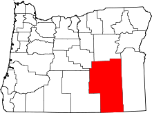
 Andrews Location in Oregon | |
| Coordinates: 42°27′51″N 118°36′44″W / 42.46417°N 118.61222°WCoordinates: 42°27′51″N 118°36′44″W / 42.46417°N 118.61222°W | |
| Country | United States |
| State | Oregon |
| County | Harney |
| Elevation | 4,157 ft (1,267 m) |
| Population (as of 1996) | |
| • Total | 0 (ghost town) |
| Time zone | Pacific |
_(harDA0166).jpg)
Andrews is a ghost town in Harney County, Oregon, United States. It is located south of Steens Mountain and near the Alvord Desert.
The community was named for Peter Andrews, who settled in the area about 1880.[1] A post office was established on Andrews' property in 1890.[1] The post office was moved north a short distance in 1900 and called "Wildhorse" or "Wild Horse".[1] Locals referred to it as "Wild Hog", however, so the postmaster changed the name to honor his friend Andrews.[1]
The population of Andrews slowly declined until only one house remained. When it burned down in 1996, the community became a ghost town.[1]
Climate
According to the Köppen Climate Classification system, Andrews has a semi-arid climate, abbreviated "BSk" on climate maps.[2]
See also
References
- ↑ 1.0 1.1 1.2 1.3 1.4 McArthur, Lewis A.; McArthur, Lewis L. (2003) [First published 1928]. Oregon Geographic Names (7th ed.). Portland, Oregon: Oregon Historical Society Press. p. 24. ISBN 9780875952772. OCLC 53075956.
- ↑ Climate Summary for Andrews, Oregon
External links
- Photo of Andrews school by chipsbuttie
- Historic images of Andrews from Salem Public Library
- Andrews listing on ghosttowns.com
| |||||||||||||||||||||||||||||