Andijan Region
Coordinates: 40°45′N 72°10′E / 40.750°N 72.167°E
| Andijan Region | |
| Andijon viloyati | |
| Region | |
| Country | Uzbekistan |
|---|---|
| Capital | Andijan |
| Area | 4,200 km2 (1,622 sq mi) |
| Population | 2,756,400 (2013) |
| Density | 452 / km2 (1,171 / sq mi) |
| ISO 3166-2 | UZ-AN |
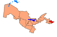 | |
Andijan Region (Uzbek: Andijon viloyati / Андижон вилояти) is a viloyat (province) of Uzbekistan, located in the eastern part of the Fergana Valley in far eastern Uzbekistan. It borders with Kyrgyzstan, Fergana Region and Namangan Region. It covers an area of 4,200 km2. The population is estimated to be around 2,756,400 [1] thus making Andijan Region the most densely populated province of Uzbekistan.
The name Andijan has originated form of the Persian word of اندکان Andakan. [2] The traditional etymology connects the name with the Turk, ethnonim Gandhi (Gandhi Turks), known from pre-Islamic period.[3]
Andijan Region is divided into 14 administrative districts. The capital is the city of Andijan. The climate is a typically continental climate with extreme differences between winter and summer temperatures.
Natural resources include deposits of petroleum, natural gas, ozokerite and limestone. As with other regions of Uzbekistan, it is famous for its very sweet melons and watermelons, but cultivation of crops can be accomplished exclusively on irrigated lands. Main agriculture includes cotton, cereal, viticulture, cattle raising and vegetable gardening.
Industry includes metal processing, chemical industry, light industry, food processing. The first automobile assembly plant in Central Asia was opened in Asaka in Andijan Province by the Uzbek-Korean joint venture, UzDaewoo, which produces Nexia and Tico cars and the Damas minibus.
Administrative divisions

| District name | District capital | |
|---|---|---|
| 1 | Andijan District | Kuyganyar |
| 2 | Asaka District | Asaka |
| 3 | Baliqchi District | Baliqchi |
| 4 | Boz District | Boz |
| 5 | Buloqboshi District | Buloqboshi |
| 6 | Izboskan District | Paytug |
| 7 | Jalalkuduk District | Akhunbabaev |
| 8 | Khodjaobad District | Khodjaobad |
| 9 | Kurgontepa District | Kurgontepa |
| 10 | Marhamat District | Marhamat |
| 11 | Oltinkol District | Oltinkol |
| 12 | Pakhtaabad District | Pakhtaabad |
| 13 | Shakhrihon District | Shakhrihon |
| 14 | Ulugnor District | Okoltin |
References
- ↑ The State Committee of the Republic of Uzbekistan on Statistics
- ↑ Dehkhoda Dictionary
- ↑ Географические названия мира: Топонимический словарь. — М: АСТ. Поспелов Е.М. 2001.
 |
Namangan Region | Jalal-Abad Region, |
| |
| |
||||
| ||||
| | ||||
| Fergana Region | Osh Region, |
| ||||||||