Anderston railway station
| Anderston | |
|---|---|
|
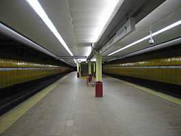
Platforms at Anderston | |
| Location | |
| Place | Anderston |
| Local authority | Glasgow |
| Coordinates | 55°51′35″N 4°16′13″W / 55.8598°N 4.2703°WCoordinates: 55°51′35″N 4°16′13″W / 55.8598°N 4.2703°W |
| Grid reference | NS579653 |
| Operations | |
| Station code | AND |
| Managed by | ScotRail |
| Owned by | Network Rail |
| Number of platforms | 2 |
|
Live arrivals/departures, station information and onward connections from National Rail Enquiries | |
| Annual rail passenger usage* | |
| 2004/05 |
|
| 2005/06 |
|
| 2006/07 |
|
| 2007/08 |
|
| 2008/09 |
|
| 2009/10 |
|
| 2010/11 |
|
| 2011/12 |
|
| 2012/13 |
|
| 2013/14 |
|
| Passenger Transport Executive | |
| PTE | SPT |
| History | |
| Original company | Glasgow Central Railway |
| Pre-grouping | Caledonian Railway |
| Post-grouping | LMS |
| 10 August 1896 | Station opened as Anderston Cross[1] |
| 3 August 1959 | Station closed[1] |
| 1968 | Station building demolished for Kingston Bridge construction |
| 5 November 1979 | Station re-opened as Anderston[1] |
| National Rail – UK railway stations | |
| * Annual estimated passenger usage based on sales of tickets in stated financial year(s) which end or originate at Anderston from Office of Rail Regulation statistics. Methodology may vary year on year. | |
| UK Railways portal | |
Anderston railway station serves Glasgow's Financial district of Anderston and, across the M8 motorway, the housing schemes of both Anderston West and the Blythswood Court estate of the Anderston Centre. It is also close to both the Hilton and Marriott hotels. It is a manned station with an island platform and most of it is underground.
History
The station was opened on 10 August 1896 by the Glasgow Central Railway which was subsequently absorbed by the Caledonian Railway. It later became part of the London, Midland and Scottish Railway during the Grouping of 1923. The station then passed on to the Scottish Region of British Railways on nationalisation in 1948. It was then closed by the British Transport Commission on 3 August 1959.[1]
The original building was demolished in 1968 as, like many other ornate and historical buildings in the area, it lay in the path of the M8 motorway. The station, reopened as part of the Argyle Line project on 5 November 1979 by the British Railways Board and Strathclyde PTE and retains some of the original architecture at platform level.
When Sectorisation was introduced in the 1980s, the station was served by ScotRail under arrangement with the PTE until the Privatisation of British Rail.
Ticket barriers came into operation on 22 June 2011.[2]
Gallery
-

Anderston station platform
Services
- 2tph to Dalmuir via Yoker
- 2tph to Dalmuir via Singer
- 2tph to Milngavie via Westerton
- 2tph to Whifflet, with an hourly extension to Motherwell
- 2tph to Larkhall via Hamilton
- 1tph to Motherwell via Hamilton
- 1tph to Cumbernauld via Hamilton and Motherwell
| Preceding station | |
Following station | ||
|---|---|---|---|---|
| Glasgow Central (Low Level) | ScotRail Argyle Line |
Exhibition Centre | ||
| Historical railways | ||||
| Glasgow Central (Low Level) Line open; station open |
Caledonian Railway Glasgow Central Railway |
Stobcross Line open; station open | ||
References
Notes
Sources
- Butt, R. V. J. (1995). The Directory of Railway Stations: details every public and private passenger station, halt, platform and stopping place, past and present (1st ed.). Sparkford: Patrick Stephens Ltd. ISBN 1-8526-0508-1. OCLC 60251199.
- Johnston, Colin; Hulme, John H. (1979). Glasgow Stations (1st ed.). Newton Abbott, Devon: David & Charles. ISBN 0-7153-7569-5. OCLC 6091133.
- Jowett, Alan (March 1989). Jowett's Railway Atlas of Great Britain and Ireland: From Pre-Grouping to the Present Day (1st ed.). Sparkford: Patrick Stephens Ltd. ISBN 1-8526-0086-1. OCLC 22311137.
