Anclote River
| Anclote River | |
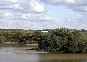 Anclote River looking east from the Pinellas Avenue bridge. | |
| Country | United States |
|---|---|
| State | Florida |
| Counties | Pasco, Pinellas |
| District | SWFWMD |
| Tributaries | |
| - left | Tarpon Bayous |
| Source | Starkey Wilderness Park |
| - location | Land O' Lakes, Florida |
| - coordinates | 28°16′44″N 82°30′48″W / 28.27889°N 82.51333°W |
| Mouth | St. Joseph Sound |
| - location | Tarpon Springs, Florida |
| - coordinates | 28°10′38″N 82°47′45″W / 28.17722°N 82.79583°WCoordinates: 28°10′38″N 82°47′45″W / 28.17722°N 82.79583°W |
| Length | 29 mi (47 km) |
| Basin | 98 sq mi (254 km2) |
The Anclote River, running for 29 miles (47 km)[1] near Tarpon Springs, Florida flows westward towards the Gulf of Mexico from its source of creeks and springs inland. The river is home to a variety of fish and wildlife. Anclote River is home to the sponging and fishing industries of Tarpon Springs (including a large shrimp industry). It is a major site for tourists of the area as it flows through the spongedocks of Tarpon Springs.
An extension of the Pinellas Trail which crosses the Anclote River was dedicated on June 15, 2004.[2] The new extension is built along abandoned Atlantic Coast Line railroad grade, which once serviced industry on the North side of the river.
List of crossings
- This list is incomplete; you can help by expanding it.

.JPG)
References
- ↑ U.S. Geological Survey. National Hydrography Dataset high-resolution flowline data. The National Map, accessed April 18, 2011
- ↑ Rondeaux, Candace. "Pinellas Trail extension work complete." St. Petersburg Times. 5 June 2004. Retrieved 15 Jan 2008 from
General references
| ||||||||||||||||||||||||||