Anaimalai
| Anaimalai ஆனைமலை | |
|---|---|
| Town | |
|
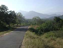
SH-17 passing south through the Annaimalai Hills, between Udumalapet and Munnar. | |
 Anaimalai Location in Tamil Nadu, India | |
| Coordinates: 10°35′N 76°56′E / 10.58°N 76.93°ECoordinates: 10°35′N 76°56′E / 10.58°N 76.93°E | |
| Country |
|
| State | Tamil Nadu |
| District | Coimbatore |
| Elevation | 258 m (846 ft) |
| Population (2001) | |
| • Total | 16,556 |
| Languages | |
| • Official | Tamil |
| Time zone | IST (UTC+5:30) |
Anaimalai is a panchayat town in Coimbatore district in the state of Tamil Nadu, India.
Geography

Anaimalai is located at 10°35′N 76°56′E / 10.58°N 76.93°E.[1] It has an average elevation of 258 metres (846 feet). =
Demographics
As of 2001 India census,[2] Anaimalai had a population of 16,556. Males constitute 49% of the population and females 51%. Anaimalai has an average literacy rate of 71%, higher than the national average of 59.5%; with 54% of the males and 46% of females literate. 9% of the population is under 6 years of age.
Places of interest
Anaimalai is well known for its salubrious climate. The "Aliar" and "Uppar" rivers run through it and is also close to Parambikulam dam, Aliar dam and Valparai. Anamalai Wildlife Sanctuary encloses the area. Sri Maasaaniamman temple is a famous place of worship. Educational Institutions: There are Govt Hr Sec School, VRT Girls Hr Sec school and Oxford Matriculation Hr Sec School There is Amman ITI in Anaimalai
References
- ↑ Falling Rain Genomics, Inc - Anaimalai
- ↑ "Census of India 2001: Data from the 2001 Census, including cities, villages and towns (Provisional)". Census Commission of India. Archived from the original on 2004-06-16. Retrieved 2008-11-01.