An Phú District
| An Phú District Huyện An Phú | |
|---|---|
| Rural district | |
|
The district is connected to the Mekong via the Hau River. The district along the river served as a stop off point by Chinese traders on the way to Phnom Penh. | |
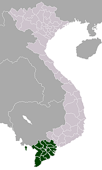
 Location in An Giang Province | |
| Country |
|
| Province | An Giang |
| Capital | An Phú |
| Area | |
| • Total | 81 sq mi (209 km2) |
| Population (2003) | |
| • Total | 178,613 |
| Time zone | Indochina Time (UTC+07:00) |
.jpg)
An Phú is a district of An Giang Province in the Mekong Delta region of Vietnam on the border with Cambodia. An Phú juts out at the western edge of Vietnam into Cambodia. As of 2003 the district had a population of 178,613.[1] The district covers an area of 209 km². The district capital lies at An Phú.[1]
History
The district is one of the most remote places in Vietnam. An Phu was a part of the Tam Phong Long region that had links with Former Phu Nam and was occupied with the Nguyễn lords in 1757. However today there is little evidence within the district to trace this ancient link.
Thanks to favorable conditions for agricultural cultivation and transport by water the Vietnamese settled in the district area. Chinese traders came along the Mekong and Hau River from Chaozhou and Guangdong and elsewhere along the route to Phnom Penh. The region was an important route in the trade, business strategy, and also strategically. Nguyễn Ánh came through here during the visit Tây Sơn military offensive. In May 1833 during the war, the soldiers across the river in the district. After that time the military battle in 1874 also saw soldiers traverse the Hau River in the area.
During the period against the French and the Vietnam War the area was too remote from other places in Vietnam to constitute and military activity.
In the Daniel Marvin's book Expendable Elite – One Soldier's Journey Into Covert Warfare, he talked about the time he worked there in the Special Forces in 1965-1966. Their camp Dan Nam camped in An Phu and they organized a group of militant Hao Hao forces to support them. He said: "An Phu is the safest place all Vietnam".
There was military invasion from 1977–78 by Pol Pot and the Khmer Rouge army and almost all of the people in An Phu had to be evacuated (mainly to the Cho Moi, Phu Tan district). The resultant damage was non-significant.
Geography
The district borders with Cambodia to the north and west. The eastern border of the district borders with Tân Châu. The southern border is the Hau Chau Doc River. After many years alluvium build up on the river created Phu An Island in the river and broke it into 2 small branches, the West Coast branch is wide at approximately 300 m.
Most of An Phu district is a plain. Every year, An Phu is affected by the flooding season in summer. Between 6 months each year, rising levels in the Mekong River from high rainfall means an average rise from 2–3 metres. The time of flooding is typically very prolonged, usually about 6 months, having a major impact on practices and production of people.
However, the location of An Phu District is quite favorable, it is an important location from Cambodia into Vietnam, connected by river and on the road and connecting the provinces of western coastal Hau River region in Vietnam with the capital Phnom Penh of Cambodia via the National Road 21.
Administrative divisions
The district is divided into two urban municipalities, An Phú and Long Bình and 12 rural communes. These are:
- Khánh An
- Phú Hữu
- Vĩnh Lộc
- Vĩnh Hậu
- Nhơn Hội
- Phú Hội
- Vĩnh Hội Đông
- Khánh Bình
- Quốc Thái
- Phước Hưng
- Đa Phước
- Vĩnh Trương
Before 1975 An Phú was a part of Long Chau Tien, but An Phu district then separated, following the 1975 merger with Tân Châu District of Phu Chau. By the year 1992 it was fully separated into the An Phú district today.
Monsoonal flooding
Located near Châu Đốc, An Phú District is famous for its rice and fish during the monsoonal flood season. The food comes in the seventh lunar month, roughly in August. The local government organises the Flood Season Festival annually. When the monsoonal season comes, many villages are inundated by water. Many houses were built on stilts to protect themselves against flooding. Many ricefields are inundated. Although produce cannot be grown in this season, the fishing catch is plentiful, and boats are the dominant mode of transport during this season.
Economy
Residents of An Phú District are mainly farmers, most of the area is under rice cultivation with alluvium soil and freshwater which also allows much fishing. Every year, when all the communes are affected by water the fields become indundated. On the Cambodian border on the other side, opposite the town of Long Binh is a market area of Cambodia known as Grass Thum (or Run Thum, Thum Kor).
As the road from An Phú to the capital Phnom Penh is Cambodia's most recent road from Vietnam it has created good conditions for trade in the region.
Education
All communes and towns have schools from kindergarten to middle school.
References
- ↑ 1.0 1.1 "Districts of Vietnam". Statoids. Archived from the original on 1 March 2009. Retrieved March 13, 2009.
Coordinates: 10°55′01″N 105°04′59″E / 10.917°N 105.083°E
| ||||||||||||||||||||||||||||||||||||||||||||||||||||||||