Amt Wachsenburg
| Amt Wachsenburg | ||
|---|---|---|
| ||
 Amt Wachsenburg | ||
Location of Amt Wachsenburg within Ilm-Kreis district 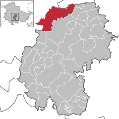
 | ||
| Coordinates: 50°52′N 10°55′E / 50.867°N 10.917°ECoordinates: 50°52′N 10°55′E / 50.867°N 10.917°E | ||
| Country | Germany | |
| State | Thuringia | |
| District | Ilm-Kreis | |
| Area | ||
| • Total | 52.34 km2 (20.21 sq mi) | |
| Population (2013-12-31)[1] | ||
| • Total | 6,373 | |
| • Density | 120/km2 (320/sq mi) | |
| Time zone | CET/CEST (UTC+1/+2) | |
| Vehicle registration | IK | |

Amt Wachsenburg is a municipality in the district Ilm-Kreis, in Thuringia, Germany. The municipality is named after the Wachsenburg Castle which is located in its center. It was formed on 31 December 2012 from the former municipalities Wachsenburggemeinde and Ichtershausen, and consists of the villages Bittstädt, Eischleben, Haarhausen, Holzhausen, Ichtershausen, Rehestädt, Röhrensee, Sülzenbrücken and Thörey.
References
- ↑ "Bevölkerung der Gemeinden, erfüllenden Gemeinden und Verwaltungsgemeinschaften nach Geschlecht in Thüringen". Thüringer Landesamt für Statistik (in German). 13 July 2013.