Ambalavao
| Ambalavao | ||
|---|---|---|
|
The town centre of Ambalavao as of November 2007 | ||
| ||
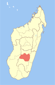
 Ambalavao Location in Madagascar | ||
| Coordinates: 21°50′S 46°56′E / 21.833°S 46.933°E | ||
| Country |
| |
| Province | Haute Matsiatra | |
| Population (2001)[1] | ||
| • Total | 30,000 | |
| • Ethnicities | Betsileo | |
| Climate | Cwa | |


Ambalavao [amˌbalaˈvaw] is a city (commune urbaine) in Madagascar.
Ambalavao is in the Haute Matsiatra region.
The city is in the most southern part of the Central Highlands, near the city of Fianarantsoa.
The Anja Community Reserve, situated about 12 km south of Ambalavao, is a small community-based reserve created to preserve and manage local natural resources.
Geography
Ambalavao is situated at the Route Nationale No. 7 Fianarantsoa-Ihosy-Tuléar at 160 km from Ihosy and 56 km from Fianarantsoa.[2]
Climate
Ambalavao has a humid subtropical climate (Köppen: Cwa).
| Climate data for Ambalavao | |||||||||||||
|---|---|---|---|---|---|---|---|---|---|---|---|---|---|
| Month | Jan | Feb | Mar | Apr | May | Jun | Jul | Aug | Sep | Oct | Nov | Dec | Year |
| Daily mean °C (°F) | 22.1 (71.8) |
21.9 (71.4) |
21.4 (70.5) |
20.3 (68.5) |
18.1 (64.6) |
16.0 (60.8) |
15.1 (59.2) |
15.9 (60.6) |
17.8 (64) |
20.2 (68.4) |
21.6 (70.9) |
22.0 (71.6) |
19.4 (66.9) |
| Average precipitation mm (inches) | 260 (10.24) |
169 (6.65) |
153 (6.02) |
27 (1.06) |
16 (0.63) |
18 (0.71) |
14 (0.55) |
15 (0.59) |
19 (0.75) |
34 (1.34) |
112 (4.41) |
234 (9.21) |
1,071 (42.16) |
| Source: Climate-Data.org[3] | |||||||||||||
Transports
There is an airport.
International relations
Twin towns - Sister cities
Ambalavao is twinned with:
-
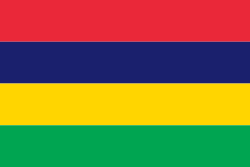 Quatre Bornes, Mauritius
  Saint-Benoit, La Réunion
See also
Coordinates: 21°50′S 46°56′E / 21.833°S 46.933°E
Gallery
-

Ambalavao main street
-

Ambalavao main street
References
- ↑ The Commune Census of by the Ilo program of Cornell University in collaboration with FOFIFA and INSTAT
- ↑ Atlas Mondial, France Loisir, page 159
- ↑ "Climate:Ambalavao". Climate-Data.org. Retrieved 11 April 2014.