Amazonis quadrangle
|
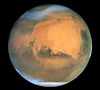
Map of Amazonis quadrangle from Mars Orbiter Laser Altimeter (MOLA) data. The highest elevations are red and the lowest are blue. | |
| Coordinates | 15°00′N 157°30′W / 15°N 157.5°WCoordinates: 15°00′N 157°30′W / 15°N 157.5°W |
|---|---|


The Amazonis quadrangle is one of a series of 30 quadrangle maps of Mars used by the United States Geological Survey (USGS) Astrogeology Research Program. The Amazonis quadrangle is also referred to as MC-8 (Mars Chart-8).[1]
The quadrangle covers the area from 135° to 180° west longitude and 0° to 30° north latitude on Mars. The Amazonis quadrangle contains the region called Amazonis Planitia. This area is considered to be among the youngest parts of Mars because it has a very low density of craters. The Amazonia period is named after this area. This quadrangle contains special, unusual features called the Medusae Fossae Formation and Sulci.
Medusae Fossae Formation
The Amazonis quadrangle is of great interest to scientists because it contains a big part of a formation, called the Medusae Fossae Formation. It is a soft, easily eroded deposit that extends for nearly 1,000 km along the equator of Mars. The surface of the formation has been eroded by the wind into a series of linear ridges called yardangs. These ridges generally point in direction of the prevailing winds that carved them and demonstrate the erosive power of Martian winds. The easily eroded nature of the Medusae Fossae Formation suggests that it is composed of weakly cemented particles,[2] and was most likely formed by the deposition of wind-blown dust or volcanic ash. Using a global climate model, a group of researchers headed by Laura Kerber found that the Medusae Fossae Formation could have easily been formed from ash from the volcanoes Apollinaris Mons, Arsia Mons, and possibly Pavonis Mons.[3] Another evidence for a fine-grained composition is that the area gives almost no radar return. For this reason it has been called a "stealth" region.[4] Layers are seen in parts of the formation. Images from spacecraft show that they have different degrees of hardness probably because of significant variations in the physical properties, composition, particle size, and/or cementation. Very few impact craters are visible throughout the area so the surface is relatively young.[5]
-

Medusae Fossae Formation and its location relative to Olympus Mons, as seen by THEMIS.
-

Plateau made up of Medusae Fossae materials and rootless cones, as seen by HiRISE.
-

Yardangs in the Medusae Fossae formation, as seen by HiRISE under HiWish program.
-

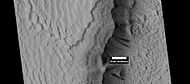
Yardangs, as seen by HiRISE under HiWish program Location is near Gordii Dorsum in the Amazonis quadrangle.
-

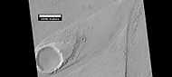
Yardangs near a crater, as seen by HiRISE under HiWish program Location is in the Amazonis quadrangle.
Images
-
Map of Amazonis quadrangle.
-
Yardangs in the Medusae Fossae formation, as seen by HiRISE under HiWish program.
-

Martian Dust Devil - in Amazonis Planitia (April 10, 2001) (also) (video (02:19)).
Sulci
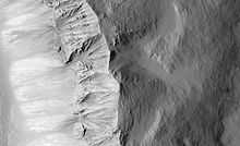
A very rugged terrain extends from the base of Olympus Mons. It is called Lycus Sulci. Sulci is a Latin term that refers to the furrows on the surface of a brain, so Lycus Sulci has many furrows or grooves. The furrows are huge—up to a full kilometer deep.[6] It would be extremely difficult to walk across it or to land a space ship there. A picture of this area is shown below.
-

Sulci in Amazonis, as seen by THEMIS. "Sulci" in Mars geography language means a furrow, like a furrow on a brain's surface. This Sulci came from the basal scarp of Olympus Mons
-

Lycus Sulci, as seen by HiRISE. Click on image for a better view of Dark Slope Streaks.
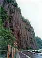
Columnar Jointing
Lava flows sometimes cool to form large groups of more-or-less equally sized columns. The resolution of the HiRISE images is such that the columns were found in various locations in 2009.
-

Columnar jointing in a crater in Marte Vallis.
-

Columnar jointing on the Earth.
-
Columnar jointing on the Earth.
-
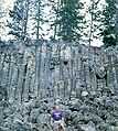
Columnar Jointing in Yellowstone National Park.
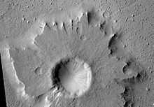
Craters
Impact craters generally have a rim with ejecta around them, in contrast volcanic craters usually do not have a rim or ejecta deposits. As craters get larger (greater than 10 km in diameter) they usually have a central peak.[7] The peak is caused by a rebound of the crater floor following the impact.[8] Sometimes craters will display layers. Since the collision that produces a crater is like a powerful explosion, rocks from deep underground are tossed onto the surface. Hence, craters can show us what lies deep under the surface.

A pedestal crater is a crater with its ejecta sitting above the surrounding terrain and thereby forming a raised platform. They form when an impact crater ejects material which forms an erosion resistant layer, thus protecting the immediate area from erosion. As a result of this hard covering, the crater and its ejecta become elevated, as erosion removes the softer material beyond the ejecta. Some pedestals have been accurately measured to be hundreds of meters above the surrounding area. This means that hundreds of meters of material were eroded away. Pedestal craters were first observed during the Mariner missions.[10][11][12]
Research published in the journal Icarus has found pits in Tooting Crater that are caused by hot ejecta falling on ground containing ice. The pits are formed by heat forming steam that rushes out from groups of pits simultaneously, thereby blowing away from the pit ejecta.[13][14]
Why are Craters important?
The density of impact craters is used to determine the surface ages of Mars and other solar system bodies.[7] The older the surface, the more craters present. Crater shapes can reveal the presence of ground ice.
The area around craters may be rich in minerals. On Mars, heat from the impact melts ice in the ground. Water from the melting ice dissolves minerals, and then deposits them in cracks or faults that were produced with the impact. This process, called Hydrothermal Alteration, is a major way in which ore deposits are produced. The area around Martian craters may be rich in useful ores for the future colonization of Mars.[15] Studies on the earth have documented that cracks are produced and that secondary minerals veins are deposited in the cracks.[16][17][18] Images from satellites orbiting Mars have detected cracks near impact craters.[19] Great amounts of heat are produced during impacts. The area around a large impact may take hundreds of thousands of years to cool.[20][21][22] Many craters once contained lakes.[23][24][25] Because some crater floors show deltas, we know that water had to be present for some time. Dozens of deltas have been spotted on Mars.[26] Deltas form when sediment is washed in from a stream entering a quiet body of water. It takes a bit of time to form a delta, so the presence of a delta is exciting; it means water was there for a time, maybe for many years. Primitive organisms may have developed in such lakes; hence, some craters may be prime targets for the search for evidence of life on the Red Planet.[27]
-
Pedestal crater in Amazonis with Dark Slope Streaks, as seen by HiRISE.
-
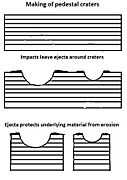
Pedestal craters form when the ejecta from impacts protect the underlying material from erosion. As a result of this process, craters appear perched above their surroundings.
-

Drawing shows a later idea of how some pedestal craters form. In this way of thinking, an impacting projectile goes into an ice-rich layer—but no further. Heat and wind from the impact hardens the surface against erosion. This hardening can be accomplished by the melting of ice which produces a salt/mineral solution thereby cementing the surface.
-
Wall of Tooting Crater, as seen by HiRISE
-

Pettit Crater rim, as seen by HiRISE
-

Nicholson mound with dark streaks, as seen by HiRISE
Gallery
-
Tartarus Colles channel, as seen by HiRISE. Scale bar is 500 meters. Click on image to see bridge across channel.
-

Olympus Mons scarp, as seen by HiRISE. Scale bar is 500 meters long.
-

Channels From Fissure, as seen by HiRISE. The fissure probably started the water flowing to make the channel. The channels look somewhat better in the enlarged view of the original image.
-

Streamlined Island in Marte Vallis, as seen by HiRISE. Click on image for good view of Dark Slope Streaks. Island is just to the west of Pettit Crater. Scale bar is 500 meters long.
-

Possible inverted stream channels in Phlegra Dorsa region, as seen by HiRISE under HiWish program. The ridges were probably once stream valleys that have become full of sediment and cemented. So, they became hardened against erosion which removed surrounding material.
-

Narrow ridges, as seen by HiRISE under HiWish program. The ridges may be caused by dikes or by some other mechanism.
-

Surfaces in Amazonis quadrangle, as seen by HiRISE under HiWish program.
-
Layers in Gordii Dorsum Region, as seen by HiRISE under HiWish program. Dark lines are Dark Slope Streaks.
-
Streamlined shape showing layers, as seen by HiRISE under HiWish program.
-

Dark slope streaks on mesa, as seen by HiRISE under HiWish program Location is Amazonis quadrangle.
See also
| Wikimedia Commons has media related to Amazonis quadrangle. |
References
- ↑ Davies, M.E.; Batson, R.M.; Wu, S.S.C. “Geodesy and Cartography” in Kieffer, H.H.; Jakosky, B.M.; Snyder, C.W.; Matthews, M.S., Eds. Mars. University of Arizona Press: Tucson, 1992.
- ↑ Grotzinger, J. and R. Milliken (eds.) 2012. Sedimentary Geology of Mars. SEPM
- ↑ Kerber L., et al. 2012. The disporsal of pyroclasts from ancient explosive volcanoes on Mars: Implications for the friable layered deposits. Icarus. 219:358-381.
- ↑ ISBN 978-0-521-85226-5
- ↑ http://themis.asu.edu/zoom-20020416a
- ↑ http://themis.asu.edu/zoom-20030606a
- ↑ 7.0 7.1 http://www.lpi.usra.edu/publications/slidesets/stones/
- ↑ Hugh H. Kieffer (1992). Mars. University of Arizona Press. ISBN 978-0-8165-1257-7. Retrieved 7 March 2011.
- ↑ Webster, Guy; Brown, Dwayne (22 May 2014). "NASA Mars Weathercam Helps Find Big New Crater". NASA. Retrieved 22 May 2014.
- ↑ http://hirise.lpl.eduPSP_008508_1870
- ↑ Bleacher, J. and S. Sakimoto. Pedestal Craters, A Tool For Interpreting Geological Histories and Estimating Erosion Rates. LPSC
- ↑ http://themis.asu.edu/feature/8
- ↑ Boyce, J. et al. 2012. Origin of small pits in martian impact craters. Icarus. 221: 262-275.
- ↑ Tornabene, L. et al. 2012. Widespread crater-related pitted materials on Mars. Further evidence for the role of target volatiles during the impact process. Icarus. 220: 348-368.
- ↑ http://www.indiana.edu/~sierra/papers/2003/Patterson.html.
- ↑ Osinski, G, J. Spray, and P. Lee. 2001. Impact-induced hydrothermal activity within the Haughton impact structure, arctic Canada: Generation of a transient, warm, wet oasis. Meteoritics & Planetary Science: 36. 731-745
- ↑ http://www.ingentaconnect.com/content/arizona/maps/2005/00000040/00000012/art00007
- ↑ Pirajno, F. 2000. Ore Deposits and Mantle Plumes. Kluwer Academic Publishers. Dordrecht, The Netherlands
- ↑ Head, J. and J. Mustard. 2006. Breccia Dikes and Crater-Related Faults in Impact Craters on Mars: Erosion and Exposure on the Floor of a 75-km Diameter Crater at the Dichotomy Boundary. Special Issue on Role of Volatiles and Atmospheres on Martian Impact Craters Meteoritics & Planetary Science
- ↑ name="news.discovery.com"
- ↑ Segura, T, O. Toon, A. Colaprete, K. Zahnle. 2001. Effects of Large Impacts on Mars: Implications for River Formation. American Astronomical Society, DPS meeting#33, #19.08
- ↑ Segura, T, O. Toon, A. Colaprete, K. Zahnle. 2002. Environmental Effects of Large Impacts on Mars. Science: 298, 1977-1980.
- ↑ Cabrol, N. and E. Grin. 2001. The Evolution of Lacustrine Environments on Mars: Is Mars Only Hydrologically Dormant? Icarus: 149, 291-328.
- ↑ Fassett, C. and J. Head. 2008. Open-basin lakes on Mars: Distribution and implications for Noachian surface and subsurface hydrology. Icarus: 198, 37-56.
- ↑ Fassett, C. and J. Head. 2008. Open-basin lakes on Mars: Implications of valley network lakes for the nature of Noachian hydrology.
- ↑ Wilson, J. A. Grant and A. Howard. 2013. INVENTORY OF EQUATORIAL ALLUVIAL FANS AND DELTAS ON MARS. 44th Lunar and Planetary Science Conference.
- ↑ Newsom H. , Hagerty J., Thorsos I. 2001. Location and sampling of aqueous and hydrothermal deposits in martian impact craters. Astrobiology: 1, 71-88.

| Quadrangles on Mars | |||||||||||||||||||||||
|---|---|---|---|---|---|---|---|---|---|---|---|---|---|---|---|---|---|---|---|---|---|---|---|
| MC-01 Mare Boreum (features) | |||||||||||||||||||||||
| MC-05 Ismenius Lacus (features) |
MC-06 Casius (features) |
MC-07 Cebrenia (features) |
MC-02 Diacria (features) |
MC-03 Arcadia (features) |
MC-04 Acidalium (features) | ||||||||||||||||||
| MC-12 Arabia (features) |
MC-13 Syrtis Major (features) |
MC-14 Amenthes (features) |
MC-15 Elysium (features) |
MC-08 Amazonis (features) |
MC-09 Tharsis (features) |
MC-10 Lunae Palus (features) |
MC-11 Oxia Palus (features) | ||||||||||||||||
| MC-20 Sinus Sabaeus (features) |
MC-21 Iapygia (features) |
MC-22 Mare Tyrrhenum (features) |
MC-23 Aeolis (features) |
MC-16 Memnonia (features) |
MC-17 Phoenicis Lacus (features) |
MC-18 Coprates (features) |
MC-19 Margaritifer Sinus (features) | ||||||||||||||||
| MC-27 Noachis (features) |
MC-28 Hellas (features) |
MC-29 Eridania (features) |
MC-24 Phaethontis (features) |
MC-25 Thaumasia (features) |
MC-26 Argyre (features) | ||||||||||||||||||
| MC-30 Mare Australe (features) | |||||||||||||||||||||||