Amari (municipality)
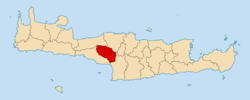
Amari (Greek: Αμάρι) is a village and a municipality in Rethymno regional unit, Crete, Greece. The seat of the municipality is the village Agia Foteini.[2] One of the major geographic features of Amari is the Amari Valley, a landform of high elevation known for olive cultivation.[3] It is thought that Monastiraki was developed by Phaistos inhabitants founding a satellite center as they pushed out into the Amari Valley.[4]
Municipality
The municipality Amari was formed at the 2011 local government reform by the merger of the following 2 former municipalities, that became municipal units:[2]
Province
The province of Amari (Greek: Επαρχία Αμαρίου) was one of the provinces of the Rethymno Prefecture. It had the same territory as the present municipality.[5] It was abolished in 2006.
References
|
|---|
|
- Area
- 8,336 km2 (3,219 sq mi)
- Population
- 623,065 (as of 2011)
- Municipalities
- 24 (since 2011)
- Capital
- Heraklion
| | | | |
|---|
| | |
|---|
| | |
|---|
| | |
|---|
| |
|
Subdivisions of the municipality of Amari |
|---|
| | Municipal unit of Kourites |
- Agia Paraskevi
- Agios Ioannis
- Apodoulou
- Fourfouras
- Kouroutes
- Lampiotes
- Lochria
- Nithavri
- Petrochori
- Platania
- Platanos
- Vizari
|
|---|
| | Municipal unit of Syvritos |
- Agia Foteini
- Amari
- Ano Meros
- Elenes
- Gerakari
- Kalogeros
- Meronas
- Monastiraki
- Pantanassa
- Patsos
- Thronos
- Vistagi
- Voleones
- Vryses
|
|---|
|