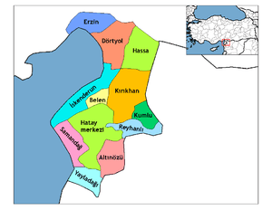
Altınözü
| Altınözü | |
|---|---|
 Altınözü | |
| Coordinates: 36°06′0″N 36°13′48″E / 36.10000°N 36.23000°ECoordinates: 36°06′0″N 36°13′48″E / 36.10000°N 36.23000°E | |
| Country | Turkey |
| Province | Hatay |
| Government | |
| • Mayor | Mehmet Cavid Alkan (AKP) |
| • Kaymakam | Köksal Şakalar |
| Area[1] | |
| • District | 471.82 km2 (182.17 sq mi) |
| Elevation | 400 m (1,300 ft) |
| Population (2012)[2] | |
| • Urban | 7,399 |
| • District | 59,169 |
| • District density | 130/km2 (320/sq mi) |
| Post code | 31750 |
| Website |
www |
Altınözü (Arabic: القصير, al-Quṣayr) is a district in the south-east of Hatay Province of Turkey, on the border between Turkey and Syria. The mayor is Mehmet Cavid Alkan (AKP).
Etymology
The area was previously known as Kuseyr a derivation from kasr the Arabic word for castle.
Geography
Altınözü stands on the Kuseyr plateau and is an area of good farmland, used for growing olives (the largest olive growing area in this part of Turkey) and also tobacco, grains and other crops. The district is watered by the Yarseli reservoir.
The district has a population of 52,819 out of which 7,379 live in the town of Altınözü. There is also a refugee camp called the Altinozu Camp that houses 1,350 Syrian Sunnis who have fled the Syrian civil war.[3]
References
- ↑ "Area of regions (including lakes), km²". Regional Statistics Database. Turkish Statistical Institute. 2002. Retrieved 2013-03-05.
- ↑ "Population of province/district centers and towns/villages by districts - 2012". Address Based Population Registration System (ABPRS) Database. Turkish Statistical Institute. Retrieved 2013-02-27.
- ↑ http://www.economist.com/news/middle-east-and-africa/21579522-refugees-are-building-life-fighting-never-far-away-will-they Syrian refugees in Turkey: Will they ever go home?