Almondsbury Interchange
| Almondsbury Interchange | |
|---|---|
|
Aerial photo of the Almondsbury Interchange | |
| Location | |
| Bristol | |
| Coordinates: | 51°33′05″N 2°33′09″W / 51.551432°N 2.552444°WCoordinates: 51°33′05″N 2°33′09″W / 51.551432°N 2.552444°W |
| Roads at junction: |
|
| Construction | |
| Constructed: | 1964 by Richard Costain Ltd |
| Opened: | 8 September 1966 |
| Maintained by: | Highways Agency |
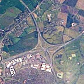
The Almondsbury Interchange in South Gloucestershire, is one of the United Kingdom's largest motorway stack interchanges. The interchange is one of only three four-level stacks in the UK, spanning a range (including slip roads) of 1 km by 1 km. It is the interchange for the M5 at junction 15 and M4 at junction 20, and is situated at the northern fringes of Bristol close to the village of Almondsbury, the Aztec West industrial estate, and Bradley Stoke.
It is immediately adjacent to junction 16 of the M5, which allows traffic on and off the motorway from the A38 road running between Bristol and Gloucester. In fact, it is so close that the slip roads from the A38 junction intertwine with those from the M5/M4 interchange. Unusually within the UK motorway system, this forces multiple lane changes for vehicles traversing some of the routes. The centres of the junctions are at Ordnance Survey Grid References ST 617837 (M5 J15/ Almondsbury Interchange) and ST 606833 (M5 J16/ A38), and are therefore 1.2 km apart.
Almondsbury Interchange was the first four-level interchange in the United Kingdom.[1] It was designed by Freeman Fox and Robert Earley.[2] The interchange was built by Richard Costain Ltd, with work commencing in May 1964. The bridge was opened by the Queen on 8 September 1966.[3]
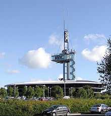
The interchange is often a traffic hot-spot, especially in the morning and evening rush hours.[4][5] It is overlooked by the RAC Tower. Traffic travelling northbound on the M5 intending to use the Second Severn Crossing (or those on the crossing wishing to use the M5 southbound from Avonmouth onwards) can bypass the interchange by using the M49 motorway.
The Interchange is at the centre of a managed motorway project which covers junctions 19 to 20 on the M4 and 15 to 17 on the M5. This became fully operational in January 2014, after being installed over a 2-year period. [6]
References
- ↑ "Oldest, widest, longest, highest". The Motorway Archive. Archived from the original on 3 October 2007. Retrieved 2007-10-04.
- ↑ Baldwin, Peter; Robert Baldwin (2003). The Motorway Achievement. Thomas Telford. p. 406. ISBN 0-7277-3196-3.
- ↑ "M4, Aust (J21) to Wickham (J14).". The Motorway Archive. Archived from the original on 8 October 2007. Retrieved 2007-10-04.
- ↑ "Almondsbury Interchange Safety Fence Upgrade". The Highways Agency. Retrieved 2008-08-05.
- ↑ "Bad Junctions - Almondsbury Interchange". CBRD. Archived from the original on 11 May 2011. Retrieved 2011-04-07.
- ↑ "M4 and M5 managed motorway project near Bristol is completed". BBC News Bristol. Retrieved 2015-01-13.