Almolonga
| Almolonga volcano | |
|---|---|
| (Cerro Quemado) | |
 The rounded hills in the middle, are part of a chain of lava domes of the Almolonga volcanic field | |
| Elevation | 3,197 m (10,489 ft) |
| Location | |
 Almolonga volcano Guatemala | |
| Location | Quetzaltenango, Guatemala |
| Range | Sierra Madre |
| Coordinates | 14°48′0″N 91°31′12″W / 14.80000°N 91.52000°WCoordinates: 14°48′0″N 91°31′12″W / 14.80000°N 91.52000°W |
| Geology | |
| Type | Stratovolcano |
| Last eruption | January to June 1818 |
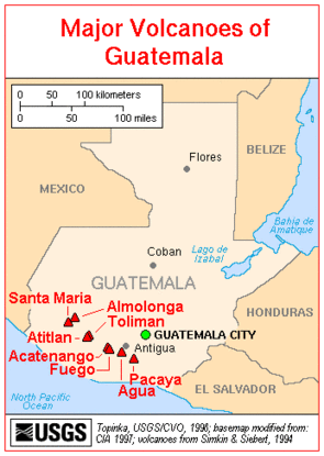
Major Volcanoes of Guatemala
The Almolonga volcano, sometimes also called "Cerro Quemado" (Burned Mountain) or "La Muela" (The Molar) for it distinct shape, is an andesitic stratovolcano in the south-western department of Quetzaltenango in Guatemala. The volcano is located near the town of Almolonga, just south of Quetzaltenango, Guatemala's second largest city.
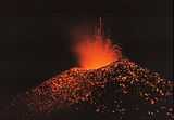
The Volcano is set along the Zunil fault zone and has a central caldera surrounded by several dacitic and rhyolitic lava domes. Cerro Quemado is the largest and youngest lava dome complex and is the only one that has erupted (1818). The northern and eastern flanks of Cerro Quemado have hot springs.
See also
| |||||||||||||||||||||||||||||