Allier (river)
| Allier | |
|---|---|
 | |
| Origin | Massif Central |
| Mouth |
Loire 46°57′34″N 3°4′44″E / 46.95944°N 3.07889°ECoordinates: 46°57′34″N 3°4′44″E / 46.95944°N 3.07889°E |
| Basin countries | France |
| Length | 421 km (262 mi) |
| Source elevation | 1,503 m (4,931 ft) |
| Avg. discharge | 140 m3/s (4,900 cu ft/s) |
| Basin area | 14,321 km2 (5,529 sq mi) |
The Allier (Occitan: Alèir) is a river in central France, and is the left tributary to the Loire River. Its source is in the Massif Central, in the Lozère département, east of Mende. It flows generally north. It joins the Loire River west of the city of Nevers.
Départements and towns along the river
- Allier: Moulins, Varennes-sur-Allier, Vichy
- Ardèche - the river is a border between this département and Lozère
- Cher
- Haute-Loire: Brioude, Langeac
- Lozère: Langogne
- Nièvre
- Puy-de-Dôme: Brassac-les-Mines, Auzat-sur-Allier, Issoire, Cournon-d'Auvergne
Tributaries include
- Chapeauroux (left side)
- Senouire (right side)
- Alagnon (left side)
- Anse
- Couze Pavin (left side)
- Dore (right side)
- Dolore (left side)
- Morge (left side)
- Sioule (left side)
- Monne (left side)
- Veyre (left side)
Ecology
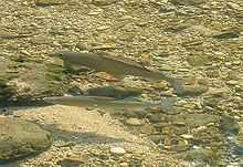
Grayling in a sunny pool
The Allier River is one of the rare places in Southern Europe where the freshwater grayling (Thymallus thymallus), known in French as ombre des rivières, occurs in a natural habitat.[1]
Grayling like to live in shoals and are sensitive to pollution. In the Allier River these fish are more abundant in the stretch of the river between Langogne and Brioude. They are economically important, being appreciated for food and fished for sport.
Gallery
-
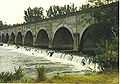
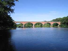
The bridge Le Guétin.
References
| Wikimedia Commons has media related to Allier River. |
| Wikisource has the text of a 1911 Encyclopædia Britannica article about Allier River. |