Aliso and Wood Canyons Regional Park
| Aliso and Wood Canyons Regional Park | |
|---|---|
| Type | Regional (Orange County, California) |
| Location | West of Laguna Niguel |
| Coordinates | 33°32′28″N 117°44′13″W / 33.5411°N 117.7369°WCoordinates: 33°32′28″N 117°44′13″W / 33.5411°N 117.7369°W |
| Area | 3,879 acres (1,570 ha) |
| Created | 1990 |
| Status | Open |
Aliso and Wood Canyons Regional Park is a major regional park and wildlife sanctuary in Orange County in the U.S. state of California, covering approximately 3,879 acres (6.02 square miles or 15.7 km²) in the lower watershed of Aliso Creek. It borders the suburban districts of Aliso Viejo, Dana Point, and Laguna Niguel, and the small city of Laguna Beach. The park encompasses the main Aliso Canyon, a water gap through the San Joaquin Hills; Wood Canyon, a major tributary valley; and portions of Laguna Canyon, Hobo Canyon, and the El Toro Cliffs.[1] Located at the southern end of the Monterey Formation, it is a major archaeological site that has yielded both artifacts of native inhabitation and ancient marine fossils dating back to the middle to late Miocene age. The park itself has an elevation range from 14 feet (4.3 m) to 515 feet (157 m), though nearby Temple Hill reaches 1,000 feet (300 m) high.
Historically, the park area was inhabited by the Juaneño (Acjachemen) and Gabrieleño (Tongva) Indians, with Aliso Creek serving as the border between the land of the two tribes. The entire park and surrounding land were part of the 1842 Rancho Niguel Mexican Land Grant until 1960, when the land was sold off to eventually become parts of three Orange County cities. The park was created in 1979 by an initial dedication of 3,400 acres (5.31 square miles or 13.75 km²) by the Mission Viejo Company; and opened in 1990.[2] Approximately 30 miles (48 km) of trails wind throughout the park, and the Aliso Water District Road parallels Aliso Creek through the canyon to its mouth. The Aliso Creek Inn and Golf Course lie near the mouth of the canyon in its narrowest stretch directly before it enters the Pacific Ocean.[3]
Name
The origin of the name "Aliso" most likely stems from the Spanish name for "alder", which is alisos. Aliso Creek took its name from this, and Aliso Canyon took its name from the creek and forms part of the present day name of the park.[4] The origin of the name "Wood Canyon Creek" is unknown, though this likely stems from the many groves of oaks and sycamores that are found in Wood Canyon.[5] Together, the names of the two creeks form the name of the park.
Geography
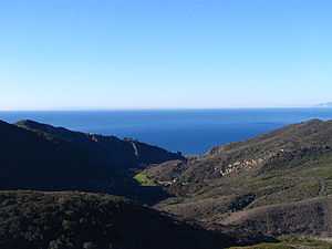
Aliso and Wood Canyons Regional Park is located in the southern San Joaquin Hills of California, within walking distance from Laguna Niguel and Aliso Viejo. Private property belonging to the Aliso Creek Inn and Golf Course and the water district between Laguna Beach and the park impedes people from accessing the Aliso Creek Trail from Aliso Creek Beach. Plans to remedy this as part of a redevelopment plan proposed by the owners of the Aliso Creek Inn and Golf Course have been put on indefinite hold as of August, 2009, after the proposals were suspended in the wake of an economic downturn.[6][7] The park is bordered by one wilderness, the Laguna Canyon Wilderness Park to the north, and one regional park, the 236-acre (0.369 sq mi) Laguna Niguel Regional Park, to the north-northeast. A habitat conservation area, the 250-acre (0.39 sq mi) Aliso Highlands Conservation Area, was planned to be designated bordering Aliso Canyon as part of the now stalled Aliso Creek Inn redevelopment project.[8]
The 3,879-acre (6.061 sq mi) park covers approximately 75% of Aliso Canyon, the entirety of Wood Canyon, and portions of Laguna Canyon, Hobo Canyon, and the El Toro Cliffs. It contains approximately 30 miles (48 km) of designated trails and roads. Two perennial streams, Aliso Creek and Wood Canyon Creek, drain most of the park, with Aliso Creek being the mainstem, with an upstream watershed, and Wood Canyon Creek being a 2.8-mile (4.5 km) tributary with most of its drainage area within the park.
Geology
Aliso Canyon was formed by Aliso Creek cutting through the San Joaquin Hills as they rose to their present height over a time span of approximately 1.2 million years. The tributary, Wood Canyon, was cut by Wood Canyon Creek into a San Joaquin Hills mountainside. Hobo Canyon is a small coastal drainage formed in much the same way as Wood Canyon.
The Aliso Canyon area is underlain with 13–36 feet (4–11 meters) of Holocene fluvial sediment. This sediment is in turn divided into two layers: the upper layer is sandy, while the lower is finer grained, dating from approximately 4,000 years before the upper.[9] The area is further underlain by Miocene and Eocene sedimentary strata, which is also the typical underlying rock for the lower Aliso Creek and San Juan Creek watersheds.
Climate
Like most of Orange County, the Aliso/Wood Canyons Regional Park has a warm, dry Mediterranean climate, with most precipitation events in the winter and early spring. The average annual precipitation is approximately 16.42 inches (417 mm).[10]
Trails
The park is accessed from Alicia Parkway on the east. The Aliso Creek Trail (also the Aliso Canyon Trail), branching off Alicia Parkway to the west, provides the major thoroughfare in the park; in this stretch it is paved and later becomes the Aliso Water Management District Road as it passes into private property in the southern part of the canyon.[11] It runs along Aliso Creek for its entire length.
The Wood Canyon Trail branches off the Aliso Canyon trail to the north and follows Wood Canyon Creek 2.8 miles (4.5 km) in a northerly direction. After travelling this distance, it makes a sharp bend back south-southwest, on a stretch of trail called the Cholla Trail. After this stretch, it becomes the West Ridge Trail and runs to Temple Hill in a fairly straight course.
Several small trails run up the mountainside dividing the West Ridge and Wood Canyon trails; these are the Mathis Canyon trail, Rock-It (to access you must go on Coyote Run trail), and Lynx trail, from south to north.[12]
Biology
The plant and animal species in the park are split within three major plant communities, divided approximately equally among the 3,879 acres (15.70 km2). These are coastal sage scrub, chaparral, and annual grassland. Chaparral often co-exists with sage scrub on the hills and slopes of the park; mostly in the southern extreme of the park. The grassland covers the valley floor, with a rich riparian zone along Aliso and Wood Canyon creeks. The park, designated a wildlife sanctuary, protects the habitat of about 137 species of nesting and migratory birds.[13]
Plants
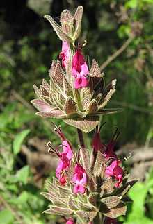
Most of Aliso Canyon consists of seasonal vegetation, which typically flourishes in spring and diminishes by the autumn. A number of sensitive plant species have their habitat protected in the park. These include many-stemmed dudleya, Pomona rattleweed, Orange County Turkish rugging, Palmer's grapplinghook, aphanisma, Laguna Beach dudleya, scrub oak, western dichondra, hummingbird sage, ocean spray, and crown-beard. Also in the park are several smaller, additional plant communities. A few groves of oak and sycamore form sparse woodland in Wood Canyon; riparian vegetation lines Aliso Creek and the lower portions of Wood and Mathis Canyons; and marshes and grassy wetlands are found along Aliso Creek. In the western portion of the park, large concentrations of native grasses can be found.[14]
Animals
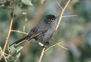
The park is one of the last sanctuaries in Orange County for large mammals such as coyotes and bobcats, which exist in small numbers throughout the canyons. Several sensitive bird, small mammal, and reptile species find refuge in the parklands, including California gnatcatcher, southwestern pond turtle, San Diego horned lizard, orange-throated whiptail, pacific pocket mouse, great egret, black-shouldered kite, northern harrier, sharp-shinned hawk, Cooper's hawk, ferruginous hawk, cactus wren, yellow warbler, and yellow-breasted chat. A population of five bald eagles also has been found in Aliso Canyon, and peregrine falcons have been sighted flying along the canyon walls.[15]

Aliso Creek was formerly inhabited by steelhead, but pollution, dam building, upstream channelization and invasive plant species, such as giant reed, as well as severe erosion problems that have in some places undermined the Aliso Creek Trail,[16] have resulted in detrimental changes to the habitat of the steelhead. Resultantly, the creek is now only inhabited by carp, which can still grow up to 18 inches (1.5 feet, 45 cm) long under the water conditions.[14]
Artifacts and fossils
The park contains a large amount of artifacts from past inhabitants of the area. Many types of these prehistoric artifacts are found throughout the park. These include, but are not limited to, open air shell middens, rock shelters, stone tools, and their production sites. It also contains historic farm equipment and buildings dating from the Rancho Niguel, a sheep and cattle ranch operational from 1842 to the 1960s. Such historical sites include the Moulton Cement Plant, Bacon House site, and Tischler Rock.
The Pecten Reef in the northeast section of the park is an above-ground exposure of the Monterey Formation, which dates back to the Miocene period. Thousands of fossils and specimens of marine mammals, fish, reptiles and coastal birds have been discovered at the site, implying that the site was once underwater. Preserved invertebrates, plankton, bryozoa, and rare red, blue and brown algae [17] have also been found there. Much of the scientific understanding for evolution, paleoenvironments and paleoclimates during the Miocene period in Orange County is based on the specimens collected from the Pecten Reef.[14]
References
- ↑ "Aliso & Wood Canyons Park". OC Parks. Archived from the original on 30 January 2009. Retrieved 2009-02-12.
- ↑ "Aliso & Wood Canyons Park Activities". OC Parks. Retrieved 2009-02-16.
- ↑ "History of Aliso Canyon". Driftwood Properties, LLC; Athens Group. Archived from the original on 2008-04-27. Retrieved 2010-04-04.
- ↑ "Aliso Canyon". Geographic Names Information System. United States Geological Survey. Retrieved 2009-02-16.
- ↑ "Wood Canyon". Geographic Names Information System. United States Geological Survey. Retrieved 2009-02-16.
- ↑ "Aliso Creek Area Redvelopment Plan". Driftwood Properties, LLC; Athens Group. Archived from the original on 2008-04-27. Retrieved 2010-04-04.
- ↑ Adelson, Andrea (2009-08-14). "Sour Economy Sinks Aliso Creek Development". Laguna Beach Independent. Retrieved 2010-03-30.
- ↑ "Top 9 Stories of 2008". Staff Reports. Coastline Pilot. 27 December 2007. Retrieved 2009-02-17.
- ↑ "Aliso Canyon Cultural Resources" (PDF). Retrieved 2009-02-12.
- ↑ "San Juan Hydrological Unit-Precipitation". Retrieved 2009-02-14.
- ↑ "Google Maps-Aliso Canyon". Archived from the original on 15 February 2009. Retrieved 2009-02-14.
- ↑ "Aliso Canyon Bike Trails". Aardvark Cycles. 13 January 2005. Archived from the original on 1 February 2009. Retrieved 2009-02-13.
- ↑ "Aliso Canyon Recreation". Archived from the original on 13 March 2009. Retrieved 2009-02-12.
- ↑ 14.0 14.1 14.2 "Aliso/Wood Canyon Wildlife and Artifacts" (PDF). Retrieved 2009-02-13.
- ↑ "Flood Corridor Protection Program-2000". Retrieved 2009-02-15.
- ↑ "OC Weekly". Archived from the original on 10 January 2009. Retrieved 2009-02-13.
- ↑ "Paleontological Resources Identification and Evaluation Report". Orange County Department of Transportation. Retrieved 2009-02-19.