Aligarh, Uttar Pradesh
| Aligarh अलीगढ़ | |
|---|---|
| Metropolitan City | |
| Nickname(s): City of Locks ; The Mecca of Education | |
 Aligarh | |
| Coordinates: 27°53′N 78°05′E / 27.88°N 78.08°ECoordinates: 27°53′N 78°05′E / 27.88°N 78.08°E | |
| Country | India |
| State | Uttar Pradesh |
| Division | Aligarh |
| District | Aligarh |
| Founded by | koil-Dor Rajputs; Aligarh-Nafaz Khan |
| Government | |
| • Body | Aligarh Nagar Nigam |
| Area | |
| • Total | 3,747 km2 (1,447 sq mi) |
| Elevation | 178 m (584 ft) |
| Population (2011) | |
| • Total | (District) 3,673,732,(City) 1,209,559 |
| • Rank | 55 |
| Languages | |
| • Official | Hindi - Hinglish |
| Time zone | IST (UTC+5:30) |
| PIN | 202001,202002 |
| Telephone code | 0571 |
| Vehicle registration | UP-81 |
| Website |
aligarh |
The city of Aligarh (formerly Allygurh) is the administrative headquarters for Aligarh Division Aligarh district and Aligarh Police Range, in the Northern Indian state of Uttar Pradesh and 126 miles (291 km) north-west of Kanpur. It is notable for being the seat of Aligarh Muslim University. The city is nicknamed Tala Nagri, ("City of Locks") for its famous Lock industry. Aligarh is located approximately 90 miles (140 km) south-east of the capital city of New Delhi. Aligarh is one out of 13 Metro Cities in UP: Agra, Aligarh, Allahabad, Bareily, Gorakhpur, Ghaziabad, Kanpur, Lucknow, Moradabad, Merrut, Varanasi, Jhansi,Saharanpur in Uttar Pradesh. Aligarh is the 55th largest[1] city in India.
History

The historian Thakur Deshraj has mentioned that the people of Kampilya were later known as Koil. The Koīl people came from Kampilya and founded the city known as Kampilgarh, situated south east of Ganges. The town of Kampilgarh later became popular as Koil which is now Aligarh.[2] Before the 18th century, Aligarh was known as Kol or Koil.[3]caste, the name of a place or mountain and the name of a sage or demon. Study of the place-name indicates that the district was once fairly well covered by forests and groves. The history of the district through the 12th century AD is obscure.[3]
According to Edwin T. Atkinson, the name Kol was given to the city by Balarama, who slew the great Asura (demon) Kol there and, with the assistance of the Ahirs, subdued this part of the doab.[4] In another account, Atkinson points out a "legend" that Kol was founded by the Dor tribe of Rajputs in 372 AD. This is further confirmed by an old fort, the ruined Dor fortress, which lies at the city centre.
Some time before the Muslim invasion, Kol was held by the Dor Rajputs. In the time of Mahmud of Ghazni, the chief of the Dors was Hardatta of Baran.[4] Statues of Buddha and other Buddhist remains have been found in excavations where the citadel of Koil stood, indicating a Buddhist influence. Hindu remains indicate that the citadel probably had a Hindu temple after the Buddhist temple.[4]
In 1194 AD, Qutb-ud-din Aibak marched from Delhi to Kol, "one of the most celebrated fortresses of Hind".[4] Qutb-ud-din Aibak appointed Hisam-ud-din Ulbak as the first Muslim governor of Koil.[4]
Koil is also mentioned in Ibn Battuta's Rihla, when Ibn Battuta along with 15 ambassadors representing Ukhaantu Khan, the Mongol Emperor of the Yuan dynasty in China, travelled to Kol city en route to the coast at Cambay (in Gujarat) in 1341.[5] According to Ibn Battuta, it would appear that the district was then in a very disturbed state since the escort of the Emperor's embassy had to assist in relieving Jalali from an attacking body of Hindus and lost an officer in the fight. Ibn Batuta calls Kol "a fine town surrounded by mango groves". From these same groves the environs of Kol would appear to have acquired the name of Sabzabad or "the green country".[4]
In the reign of Akbar, Kol was made a Sirkar and included the dasturs of Marahra, Kol ba Haveli, Thana Farida and Akbarabad.[4] Both Akbar and Jahangir visited Kol on hunting expeditions. Jahangir clearly mentions the forest of Kol, where he killed wolves.[3]
During the time of Ibrahim Lodhi, Muhammad, son of 'Umar, was the governor of Kol. He built a fort at Kol and named the city Muhammadgarh, after himself, in 1524–25. Sabit Khan, who was then the governor of this region, of Farrukh Siyar and Muhammad Shah, rebuilt the old Lodhi fort and named the town after himself: Sabitgarh.
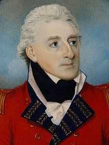
The Jat ruler, Surajmal, with help from Jai Singh of Jaipur and the Muslim army, occupied the fort of Koil. Koil was renamed Ramgarh and finally, when a Shia commander, Najaf Khan, captured it, he gave it its present name of Aligarh. Aligarh Fort (also called Aligarh Qila), as it stands today, was built by French engineers under the command of French officers Benoît de Boigne and Perron.[3]
Battle of Aligarh (1803)
The Battle of Aligarh was fought on 1 September 1803 during the Second Anglo-Maratha War (1803–1805) at Aligarh Fort. The British 76th Regiment, now known as the Duke of Wellington's Regiment besieged the fort, which was under the control of the French officer Perron, and established British rule. In 1804, the Aligarh district was formed by the union of the second, third and fourth British divisions with the addition of Anupshahr from Muradabad and Sikandra Rao from Etawa. On 1 August 1804, Claude Russell was appointed the first Collector of the new district.[6]
Administration
Aligarh district is divided into five tehsils, namely Koil tehsil, Khair Tehsil, Atrauli, Gabhana and Iglas. These tehsils are further divided into 13 blocks.
The city is administered by Aligarh Municipal Corporation, which is responsible for performing civic administrative functions administered by Mayor and Municipal Commissioner (PCS Officer). Infrastructure development of the city is looked after by the Aligarh Development Authority (ADA) administered by Divisional Commissioner (Chairman) and Vice Chairman (PCS Officer).
Aligarh is the headquarters of Aligarh Police Range and Aligarh Division. A DIG looks after Aligarh for legal condition and law, Commissioner also looks for 4 district of Aligarh Division(Aligarh, Etah, Hathras, Kanshiram Nagar).
Geography
Location
Aligarh is located at the coordinates 27°53′N 78°05′E / 27.88°N 78.08°E.[7] It has an elevation of approximately 178 metres (587 feet). The city is in the middle portion of the doab, the land between the Ganges and the Yamuna rivers. The G.T. Road passes through.
Climate
Aligarh has a monsoon-influenced humid subtropical climate, typical of north-central India. Summers start in April and are hot with temperatures peaking in May. The average temperature range is 28–33 °C (82–91 °F). The monsoon season starts in late June, continuing till early October, bringing high humidity. Aligarh gets most of its annual rainfall of 800 millimetres (31 in) during these months. Temperatures then decrease, and winter sets in December, and continues till February. Temperatures range between 5–11 °C (41–52 °F). Winters in Aligarh are generally mild, but 2011–12 experienced the lowest temperature of 1 °C . The fog and cold snaps are at extreme level.
| Climate data for Aligarh | |||||||||||||
|---|---|---|---|---|---|---|---|---|---|---|---|---|---|
| Month | Jan | Feb | Mar | Apr | May | Jun | Jul | Aug | Sep | Oct | Nov | Dec | Year |
| Record high °C (°F) | 30.7 (87.3) |
33.3 (91.9) |
41.7 (107.1) |
44.8 (112.6) |
47.5 (117.5) |
46.7 (116.1) |
44.5 (112.1) |
42.1 (107.8) |
40.2 (104.4) |
41.7 (107.1) |
36.1 (97) |
32.8 (91) |
47.5 (117.5) |
| Average high °C (°F) | 20.6 (69.1) |
23.6 (74.5) |
30.0 (86) |
36.8 (98.2) |
40.1 (104.2) |
39.3 (102.7) |
34.6 (94.3) |
33.2 (91.8) |
33.8 (92.8) |
33.0 (91.4) |
28.3 (82.9) |
22.5 (72.5) |
31.3 (88.3) |
| Average low °C (°F) | 7.4 (45.3) |
9.5 (49.1) |
14.1 (57.4) |
20.1 (68.2) |
24.5 (76.1) |
26.6 (79.9) |
26.0 (78.8) |
25.4 (77.7) |
23.8 (74.8) |
18.8 (65.8) |
12.9 (55.2) |
8.5 (47.3) |
18.1 (64.6) |
| Record low °C (°F) | 0.0 (32) |
1.7 (35.1) |
3.9 (39) |
10.9 (51.6) |
15.5 (59.9) |
18.6 (65.5) |
19.9 (67.8) |
19.9 (67.8) |
14.8 (58.6) |
11.0 (51.8) |
2.9 (37.2) |
1.2 (34.2) |
0.0 (32) |
| Average precipitation mm (inches) | 15.2 (0.598) |
13.9 (0.547) |
8.5 (0.335) |
8.8 (0.346) |
21.0 (0.827) |
68.5 (2.697) |
217.7 (8.571) |
247.4 (9.74) |
104.1 (4.098) |
31.4 (1.236) |
4.2 (0.165) |
11.0 (0.433) |
751.8 (29.598) |
| Avg. rainy days | 1.5 | 1.4 | 1.0 | 0.9 | 2.2 | 4.1 | 10.2 | 11.6 | 5.2 | 1.4 | 0.5 | 0.8 | 40.7 |
| Source: India Meteorological Department (record high and low up to 2010)[8][9] | |||||||||||||
Demographics
The provisional data of 2011 census showed the Aligarh urban area with a population of 1,209,559. Males outnumber females 482,828 to 426,731. The literacy rate was 70.54 per cent.[10]
Economy
The city is an agricultural trade centre.[11] Agricultural product processing and manufacturing are important.[12]
Aligarh is an important business centre of Uttar Pradesh and is most famous for its lock industry. Aligarh locks are exported across the world. In 1870, Johnson & Co. was the first English lock firm in Aligarh. In 1890, the company initiated production of locks on a small scale here.[13]
Aligarh is also famous for brass hardware and sculpture. Today, the city holds thousands of manufacturers, exporters and suppliers involved in the brass, bronze, iron and aluminium industries.
Aligarh is also a big centre of zinc die casting. There are thousands of pneumatic hot chamber die casting machines here . But many exporters have adopted latest technology and have installed fully automatic, computerised hot chamber machines. Indian Diecasting Industries at Sasni Gate Area is the most renowned manufacturer in this line and they are capable of meeting international quality norms.
Harduaganj Thermal Power Station (also referred as Kasimpur Power House) is 15 km from the city. Narora Atomic Power Station is located 50 km from Aligarh. Despite its proximity to two large power stations, frequent power cuts are normal in Aligarh.
Aligarh hosts Heinz-sauce manufacturing unit in Manzurgarhi, Satha sugar factory on the Aligarh-Kasimpur Power House route and a cement factory of UltraTech Cement company. Indian Oil Boteling Plant exits at Andla in Khair. Wave Distallery (Kingfisher bear) located at Atrauli in Aligarh.
Development
Aligarh is the 55th fastest-growing city in India. Following major development projects are under construction in City.
- Govt. Homeopathic Medical College and Hospital, Chherat
- Super Speciality Trauma Center at AMU
- Sports University at Khair Road
- ISKON Temple at Tala Nagari
- World class Shooting Range at Chherat
- Astro Turf Hockey Stadium in AMU
- Country Inn 5 Star Hotel at Gandhi Park, GT Road
- NH-93 Kathpula-Jamalpur Crossing 4 Lane work
- NH-93 Aligarh-Agra section 2 Lane work
- Aligarh-Mathura 4 Lane highway work
- Aligarh-Khair-Palwal 4 Lane highway work
- Aligarh-Moradabad 4 Lane highway work
- NH-91 Aligarh-Ghaziabad 4 Lane highway work
- Gabhana-Dhanipur 4 Lane Bypass as a part of Ring Road
- World Class Golf Corse at AMU Aligarh
- 5 Star Country Inn Hotel near to Aligarh Junction(Will be ready in 2017)
- Big black shiv murti temple at bairamganj near jattari
Education
Aligarh is growing as Education Hub. Aligarh has the following Education Universities and Colleges.
- Aligarh Muslim University, Aligarh (Central Govt. university)
- IGNOU Aligarh Region, Marris Road
- Jawaharlal Nehru Medical College, AMU, Aligarh
- Sir Ziauddin Dental College, AMU, Aligarh
- Zakir Hussain College of Engineering and Technology, AMU, Aligarh
- Abdullah Girls College, AMU, Marris Road
- Jamia Urdu, Dodhpur, Aligarh
- Jamia-Al-Barkaat, Anoopshahr Road, Near Jamalpur Railway Crossing, Aligarh
- Ajmal Khan Tibbiya College, AMU, Aligarh
- D S College, GT Road (Agra University college)
- S V College, GT Road (Agra University college)
- Tikaram Girls College, Ramghat Road (Agra University college)
- Gyan College, Agra Road (Agra University college)
- Shivdan Singh Engineering College, Mathura Road (UPTU College)
- IIMT, Talanagari, Aligarh (UPTU College)
- Aligarh College of Engineering and Technology, Sasni Gate on Mathura Road (UPTU College)
- ITM, Khair Road (UPTU College)
- PM College, Khair Road (Agra University College)
- S.K.D.M Degree & Polytechnic College Khair Road Lodha
- Al-Barkaat Institute of Management Studies, Jamalpur (UPTU College)
- Aligarh College of Pharmacy (UPTU College)
- Vivekananda College of Technology & Management, Mathura Road (UPTU College)
- Our Lady of Fatima Higher Secondary School, Aligarh, Ramghat Road (CBSE)
- St. Fidelis School, Ramghat Road (CBSE)
- Delhi Public School DPS, Agra Road (CBSE)
- Delhi Public School DPS, Ramghat Road (CBSE)
- Iqra Public School, Quarsi Bypass Road (CBSE)
- Ayesha Tarin Modern Public School, Chherat (CBSE)
- Aligarh Public School, AMU Road (CBSE)
- Kendriya Vidyalaya, Ramghat Road (CBSE)
- Heritage International School, Talanagari (CBSE)
- Nurture International School (Branch of City Montesori Lucknow), Talanagari (CBSE)
- Shantiniketan World School, Talanagari (CBSE)
- Jagran Public School JPS, Mathura Road (CBSE)
- Three Dots Sewamarg Public School, Ramghat Road (CBSE)
- Wisdom Public School, Quarsi (CBSE)
- Krishna International School, Sarsaul (CBSE)
- Radiant Star Public School, Khair Road (CBSE)
- Blue Bird Sr Secondary School, Banna Devi (CBSE)
- Gagan Public School, Agra Road (ICSE)
- Zakir Husain Model Sr Sec School, Dodhpur (CBSE)
- Maharishi Vidya Mandir, Agra Road (CBSE)
- G D Public School, Khair Road (CBSE)
- Mother Touch International School, Ramghat Road (CBSE)
- B.L. Jain Inter College, Aligarh
- H.B. Inter College, G.T. Road, Aligarh
- ACN College of Engineering and Management Studies, Kasimpur Road, Aligarh (UPTU College)
- Chauhan Indravati Inter College, Anoopshahar Road, Jawan Sikandarpur,(Aligarh)
- Brilliant Public High School, Shankar Vihar Quarsi, Aligarh (UP)
- South Point Public School, Aligarh (U.P.)
There are about 30 UP Board Inter Colleges in the City also.
Locations
Cultural landmarks
Aligarh has several popular landmarks. Most notable few of them are Aligarh fort, Another one is Teerthdham Mangalayatan Mandir and Dor fortress (1524), which is now in ruins, lies at the city's centre; its site is in the area now called Upper Kot and is occupied by an 18th-century mosque.
The Annual Cultural Exhibition, popularly known as Numaish, is held at the exhibition ground in January and February.
Many cultural-based institutes are in Aligarh city. Examples include
- Sangeetika, Centre Point,
- Durga Sanskratik Kala Kendra
- Sanskar Bharti(Cultural wing of Rastriya Swyamsevak Sangh)
- ISKCON Aligarh Temple
A. C. Bhaktivedanta Swami Prabhupada visited Aligarh in October 1976
founded by Varshney community of Aligarh.
Historical places
- Shekha Jheel, Bird Sanctuary
- Maulana Azad Library(AMU campus) (Estd 1875)
- Clock Tower known in Hindi Ghanta Ghar
- Aligarh Fort, known as Aligarh Quila
- Achal Taal, Historical Pond
- Dharnidhar Sarovar, Beswan, Tapobhumi of Vishwamitra
- Jama Masjid (Mosque) (Const 1727)
Places of worship
"Sai Mandir" at Sarsol on G.T. Road. Many old Hindu temples in the city are located near Achal Taal (Opposite to Dharma Samaj College) Another landmark is Sir Syed Masjid in Aligarh Muslim University's campus.
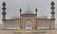
The city contains tombs of Muslim saints Hazrat Shah Jamal (R.A) at Shah Jamal Area Barchi Bahadur was the one of the Decendants of Shah Jamal .[12] Aligarh has a very renowned tomb, Baba Barchi Bahadur, at Kath Pula. Another old Jain temple with fresco painted ceilings is located behind Khirni Gate Police Chowky at Agra Road in the main City.
A famous Jainism Teerth Dhaam "Mangalayatan Teerth Dhaam" was built at Agra Road.
Aligarh Muslim University
Aligarh Muslim University (AMU) is one of the oldest central university. It was established by Sir Syed Ahmed Khan as Madrasatul Uloom Musalmanan-e-Hind, in 1875–78 which later became Mohammedan Anglo-Oriental College (MAO College). It was designed to train Muslims for government service in India and prepare them for advanced training in British universities. The Mohammedan Anglo-Oriental College became Aligarh Muslim University in 1920. It is famous for its Law, Medical and Engineering College.
Markets and shopping
Aligarh include the Centre Point Market, Railway Road Market, Amir Nishan, Phool Chok, Halwai khana, Jamalpur Market, Shamshad Market, Mahavir Ganj, (Houseking Locks) Mohammad Ali Road, Upper Fort (known as Uppar Kot), is the best place for shopping for brand Locks. Centre Point Market is the best place for shopping for brand enthusiasts. Centre Point having the showrooms of major Brands.
Aligarh is the centre of whole sale markets for specific items.
- Achal Taal Market-Books
- Shamshad Market-Books
- Sarafa Bazar-Jwellery
- Barahdwari-Daal Mandi
- Phaphala Street-Pharmacy Market
- Mamu Bhanja-Electronic Items
- Bhagwati Palace-Computer Parts
- Shahkamal Road-Auto Parts
- Rafatganj-Paper Market
- Madar Gate-Band Market
- Ali Road-Locks
- Rasalganj-Furnitures
- Phool Chock-Flowers
- Sarsaul-Automobile Showrooms
- Patthar Bazar- Marble Market
For online shopping of suits and female clothing, there is an online store on Facebook named Ada Boutique which is an online store of Aligarh.
Media
Aligarh currently has 3 FM Radio stations:
- 92.7 MHz Big FM
- 101.3 MHz All India Radio,
- 90.4 MHz Mangalvaani,
Hindi Newspapers include Amar Ujala, Dainik Jagran, Hindustan Dainik, DLA, Pravada Dainik, Avadhnama, Punjab Kesari etc. HT Media Ltd has recently come out with printing facilities in Aligarh.
Organisations
Social organisations in Aligarh city, include
- [ [Rastriya Brahamin Mahasabha Uttar Pradesh ]]
- Rotary Club
- Rashtriya Swayamsevak Sangh, Dwarikapuri, Agra Road
- Vishwa Hindu Parishad, G.T. Road
- Sanskar Bharti, Sasni Gate
- SIMMI, a banned Islamic student organisation (formed in April,1977)
- Chetana Jagrati Punj
- Kala Jagriti Samiti
- Shoshit Siksha Sadan Sansthan
- Manav Upkar Samiti
- Bharatiya Sewa Sansthan
- Golden Group and Welfare Trust
- Varshney Sabha
- Kulshrestha Sabha
Culture & folk music
A various styles in music and art in folk songs of North India's Braj region includes are-
- Rasiya , late Satto Sharma (Artist) Atrauli, Aligarh
- Ramlila
- Nautanki
- Dhola
- Brijwood
- Krishnaleela
Transport
By Rail
Aligarh Junction railway station is the primary railway station for Aligarh city and is a major stop on the Delhi-Kolkata route. It connects Aligarh to the states of West Bengal, Odisha, Bihar, Jharkhand, north-east and most of Uttar Pradesh, and important cities such as New Delhi, Mumbai, Kolkata, Bhopal, Indore, Jammu, Gwalior, Lucknow, Jhansi, Puri, Kanpur, Agra, Varanasi and Jaipur. Aligarh railway station handles over 136 trains daily (in both directions) and serves around 204,000 passengers everyday. Aligarh also having one Branch Railway Line to Bareily. Aligarh City has following railway stations:
- Aligarh Junction- a A-Class Rly. Station
- Somna (Gabhana) railway station
- Mahrawal railway station
- Kalua railway station
- Daudkhan railway station
- Mandrak railway station
- Harduaganj railway station(Satha, near Kasimpur Power House)
- Manjoorgarhi railway station (Chherat)
By Road
Aligarh is located at a distance of 140 km (2.5 hours far by Car) from New Delhi. It is one of the Division of UPSRTC. Uttar Pradesh State Road Transport Corporation (UPSRTC) buses serve cities all over the state and cities in Uttranchal, Rajasthan, Madhya Pradesh and Haryana.
Aligarh City has 2 UPSRTC bus stations:
- Aligarh Depot bus station
- Masoodabad (Budh Vihar) Depot bus station
- ISBT proposed at Sarsaul.
There are buses plying from Aligarh to Delhi at frequent intervals via
1) Khair, Tappal, Palval, faridabad, delhi. the route is under construction between Khair and Palval and should be strictly avoided for cars. No toll charges.
2) Khair, Tappal, Yamuna expressway, G Noida, Noida, Delhi, Gurgaon. - Best and recommended Route for Delhi, Noida, Gurgaon. Toll Charges are 100 rs between aligarh and delhi.
3) Old GT Road, Ghaziabad, Delhi. The route is again under construction.
Haryana roadways buses are in better condition than UP roadways buses and run on time.
Following Highways are connected to Aligarh.
- National Highway 91- It connects Kolkata to National capital New Delhi. Ghaziabad-Aligarh section is 4 Lane in under construction.
- National Highway 93- It connects Moradabad to Taj Nagri Agra via Aligarh. Aligarh-Agra section is constructed as Brijbhoomi Expressway.
- Yamuna Expressway- It is 6 Lane Expressway Noida-Agra crossing at Tappal in Khair Tehsil from where Khair City is 30 km.
Aligarh City also have Mahanagar Bus Service (City Bus Service) which provides a local transport to Aligarh.
- Route-1 J N Medical-Uperkot
- Route-2 Gandhi Park-Sarsaul
- Route-3 Ghantarbagh-Quarsi
- Route-4 Gandhi Park-Boner
- Route-5 Etah Chungi-Collectrate
By Air
Nearest International Airport from Aligarh is Indira Gandhi International Airport, New Delhi. It is just 140 km from Aligarh.Aligarh Airport is in under construction, it is situated at Dhanipur on NH 91 and currently Dhanipur Air Strip is used as Flying Club. The Government of Uttar Pradesh signed a MoU with the Airports Authority of India (AAI) in February 2014 for the development of the airport.[1]
Banks
- Gramin Bank of Aryavart
- ICICI Bank
- SBI Bank
- HDFC Bank
- Punjab National Bank
- Jammu And Kashmir Bank
- Yes Bank
- ING Vysya Bank
- Axis Bank
- IDBI Bank
- Bank of Baroda
- Union Bank Of India
- Oriental Bank
- District Cooperative Bank
- Corporation Bank
- Bank Of India
- Canara Bank
- Sydnicate Bank
- Indusland Bank
- Central Bank Of India
Political Parties
- Parcham Party of India by Saleem Pirzada (National President)
- Sarvjan Samaj Party
Notable personalities
Educationist
- Sir Syed Ahmad Khan founder of Aligarh Muslim University
- Sir Ziauddin Ahmed, Mathematician, M.L.A. (Central), Longest term Vice Chancellor and pillar of Aligarh Muslim University Movement. He established several institution including J.N. Medical College.
Spiritual
- Swami Haridas, spiritual poet and classical musician of Vrinaban, Mathura. born at Khereswar Dham, Khair
Writers, poets and publishers
- Saghar Nizami , Urdu Poet
- Qurratulain Hyder, a Padma Bhushan, Urdu novelist, writer and journalist
- Jainendra Kumar, famous Hindi writer
- Akhlaq Mohammed Khan, pen name Shaharyar, Urdu poet, Bollywood lyricist and served as Professor at Aligarh Muslim University
- Maitreyi Pushpa, Notable Hindi fiction writer
- Prem Kishore Patakha, Hindi Humorous Poet
- Gopaldas Neeraj, poet, recipient of Padma Bhushan
- Munshi Newal Kishore famous book publisher
- A.R. Akela, Dalit author and publisher, owner of "Anand Sahitya Sadan"
Historians
- Mohammad Habib (1895–1971), noted Indian historian and served as Professor Emeritus at Aligarh Muslim University
- Irfan Habib, eminent Indian historian and Professor Emeritus at Aligarh Muslim University
Freedom Fighters
- Captain Abbas Ali, freedom fighter, Captain of Indian National Armywhich lead by Netaji Subhash Chandra Bose
- Atal Moksha (Congress) - Gandhian, Started his contribution to freedom struggle with Bhagat Singh later inspired by Mahatama Gandhi's ideology joined congress. His Original name was Mahender Singh but later he has given name as Atal (immovable) Moksha (Peace) by Gandhiji. He has spent many years in Jail duering freedom movement
Film actors
- Naseeruddin Shah, Indian film actor and director
- Bharat Bhushan, Bollywood actor, scriptwriter and producer
- Chandrachur Singh, Bollywood actor
- Shad Khan, anchor, actor and director
- Salim Shah, Indian television and film actor
- Hasan Zaidi, Indian television actor
- Aadesh Chaudhary, Indian television actor
- Nitin Chauhaan, Indian television actor
- Ravindra Jain, Bollywood music director
- Basharat Peer, Indian journalist and scriptwriter, written script for feature film Haider(2014)
- Zarina
Sports persons
- Annu Raj Singh, international shooter
- Piyush Chawla, Cricketer
- Zafar Iqbal, Former Hockey Captain of India
Political Persons
- Kalyan Singh, Ex. CM of Uttar Pradesh and Current Governor of Rajsthan
- Satish Kumar Gautam, current MP from, Aligarh (Lok Sabha constituency)
- Thakur Dalveer Singh, MLA from Baruli vidhansabha constituency
- Sheela Gautam, Ex MP & owner of Sleepwell
- Jamal Khwaja, Ex MP
- Bijendra Singh, Ex MP
- Zafar Alam, MLA & owner of Link locks
- Thakur Jaiveer Singh, Ex MLA (Now MLC)
- Chaudhary Sunil Singh, Ex MLC
Interpreter
- Pradeep Chauhan, Software Engineer
- Varun Bhardwaj, Businessman
- Vipin Rawat, Chartered Financial Analyst
- DEV DUTT SINGH, IT Consultant
- Madan Sharam , Director/Chairman
Medicine
- Hakim Syed Zillur Rahman, Unani physician and author
- Syed Ziaur Rahman, Unani physician and author
- Khwaja Abdul Hamied, Pharmacist, founder of Cipla(a pharmaceutical company)
Social activist
- Jai Kishan Das, close associate of Sir Syed Ahmad Khan
- Rajiv Dixit, Indian social activist.
- Roohi Zuberi Advocate, Social worker, political activist.
- Madan Sharma Social worker, political activist.
References
- ↑ "Top cities of India by population, Census 2011". Retrieved 18 April 2014.
- ↑ Kampilya
- ↑ 3.0 3.1 3.2 3.3 "Histor11".
- ↑ 4.0 4.1 4.2 4.3 4.4 4.5 4.6 Edwin T. Atkinson (8 June 2007). Descriptive and Historical Account of the Aligarh District. p. 484. Retrieved 13 October 2011.
- ↑ The Adventures of Ibn Battuta, by Ross E. Dunn, p. 215
- ↑ Edwin T. AtkINSON (8 June 2007). Descriptive and Historical Account of the Aligarh District. p. 348. Retrieved 13 October 2011.
- ↑ "Falling Rain Genomics, Inc – Aligarh". Fallingrain.com. Retrieved 13 October 2011.
- ↑ "Aligarh Climatological Table Period: 1971–2000". India Meteorological Department. Retrieved April 15, 2015.
- ↑ "Ever recorded Maximum and minimum temperatures up to 2010" (PDF). India Meteorological Department. Retrieved April 15, 2015.
- ↑ "Urban Agglomerations/Cities having population 1 lakh and above" (PDF). Provisional Population Totals, Census of India 2011. Retrieved 7 July 2012.
- ↑ "India9.com". India9.com. 7 June 2005. Retrieved 13 October 2011.
- ↑ 12.0 12.1 "Britannica". Britannica. Retrieved 13 October 2011.
- ↑ Pawan JainPawan Jain (3 June 2003). "Times of India". Timesofindia.indiatimes.com. Retrieved 13 October 2011.
Further reading
- Aligarh in My Days (Interviews of former Vice-Chancellors of Aligarh Muslim University), Ed. Syed Ziaur Rahman, Non-Resident Students' Centre, Aligarh Muslim University, Aligarh, 1997.
- Atkinson, Edward (2010) [1875]. Descriptive And Historical Account of the Aligarh District. Nabu Press. ISBN 1-147-42719-4.
| ||||||||||
| ||||||||||||||||||||||||||||||||||||||||||||||