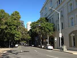
Alice Street, Brisbane
| Alice Street Queensland | |
|---|---|
 | |
| Alice Street from Edward Street intersection. | |
| Coordinates | 27°28′27″S 153°01′41″E / 27.474104°S 153.02806°ECoordinates: 27°28′27″S 153°01′41″E / 27.474104°S 153.02806°E |
| General information | |
| Type | Street |
| Location | Brisbane |
Alice Street is a central road in Brisbane, Australia. It is the most southern major road in the city's central business district, running parallel to the other female named streets in the city.
In a pocket of land between a curve of the Brisbane River and Alice Street is the City Botanic Gardens and Parliament House. Access to the Gardens Point QUT campus and the Riverside Expressway is provided at the western end of the street.
The male named streets from William Street to Edward Street end at intersections with Alice Street.
Brisbane Ferries operated from the eastern end as early as the 1860s.
Heritage listings
Alice Street has a number of heritage-listed sites, including:
- 69 Alice Street: Parliament House[1]
- 147 Alice Street: City Botanic Gardens[2]
- 210 Alice Street: Britannia Foundry[3]
- 2 Edward Street: Old Mineral House[4] (corner of Alice Street)
- Sections of Albert St, George St, William St, North Quay, Queen's Wharf Rd,: Early Streets of Brisbane[5]
Major intersections
See also
Australian Roads portal
References
- ↑ "Parliament House (entry 14844)". Queensland Heritage Register. Queensland Heritage Council. Retrieved 2013-06-19.
- ↑ "Brisbane Botanic Gardens (entry 14842)". Queensland Heritage Register. Queensland Heritage Council. Retrieved 2013-06-19.
- ↑ "Public Works Depot (entry 14843)". Queensland Heritage Register. Queensland Heritage Council. Retrieved 2013-06-19.
- ↑ "Old Mineral House (entry 14867)". Queensland Heritage Register. Queensland Heritage Council. Retrieved 2013-06-19.
- ↑ "Early Streets of Brisbane (entry 31551)". Queensland Heritage Register. Queensland Heritage Council. Retrieved 2013-06-19.
External links
![]() Media related to Alice Street, Brisbane at Wikimedia Commons
Media related to Alice Street, Brisbane at Wikimedia Commons