Alibori Department
| Alibori | |
|---|---|
| Department | |
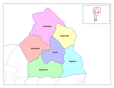
 Map highlighting the Alibori Department | |
| Coordinates: 11°07′43″N 02°56′13″E / 11.12861°N 2.93694°ECoordinates: 11°07′43″N 02°56′13″E / 11.12861°N 2.93694°E | |
| Country |
|
| Capital | Kandi |
| Area[1] | |
| • Total | 26,242 km2 (10,132 sq mi) |
| Population (2013 Census) | |
| • Total | 868,046 |
| • Density | 33/km2 (86/sq mi) |
| Time zone | WAT (UTC+1) |
Alibori is the largest and northernmost département of Benin, with an area of 26,242 km² and a population of 868,046 (at the May 2013 Census). The department is subdivided into six communes, each centered at one of the principal towns: Banikoara, Gogounou, Kandi, Karimama, Malanville, and Ségbana. The départment borders the countries of Burkina Faso, Niger, and Nigeria. The départments of Atakora and Borgou also border Alibori.
The département was created in 1999 when it was split off from Borgou. Since 2008, the capital has been Kandi.
Communes of Alibori