Alfter
| Alfter | ||
|---|---|---|
| ||
 Alfter | ||
Location of Alfter within Rhein-Sieg-Kreis district 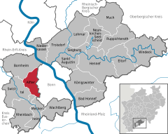
 | ||
| Coordinates: 50°44′08″N 07°00′33″E / 50.73556°N 7.00917°ECoordinates: 50°44′08″N 07°00′33″E / 50.73556°N 7.00917°E | ||
| Country | Germany | |
| State | North Rhine-Westphalia | |
| Admin. region | Köln | |
| District | Rhein-Sieg-Kreis | |
| Government | ||
| • Mayor | Rolf Schumacher (CDU) | |
| Area | ||
| • Total | 34.73 km2 (13.41 sq mi) | |
| Population (2013-12-31)[1] | ||
| • Total | 23,003 | |
| • Density | 660/km2 (1,700/sq mi) | |
| Time zone | CET/CEST (UTC+1/+2) | |
| Postal codes | 53347 | |
| Dialling codes | 02222, 0228 | |
| Vehicle registration | SU | |
| Website | www.alfter.de | |

Alfter is a municipality in the Rhein-Sieg district, in North Rhine-Westphalia, Germany. It is situated approximately 6 km west of Bonn.
Location
The community of Alfter lies west of former capital of Bonn, on the southern Ridge of the "Vorgebirge". It borders along the city of Bornheim (Alfter being more in the south), Bonn lying to the east, and North of the cities (Rheinland) of Meckenheim and Rheinbach. To the west lays the community of Swistal. Alfter consists of a total area of 35 km², of which 18 km² is used for agricultural purposes and 8 km² is forest.
References
- ↑ "Amtliche Bevölkerungszahlen". Landesbetrieb Information und Technik NRW (in German). 4 September 2014.
| ||||||||