Alfredtown
For the town in the United States, see Alfred (town), New York. For the suburb of Ballarat, see Alfredton, Victoria.
| Alfredtown New South Wales | |
|---|---|
|
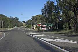
Sturt Highway in Alfredtown | |
|
Alfredtown | |
| Coordinates | 35°10′0″S 147°31′0″E / 35.16667°S 147.51667°ECoordinates: 35°10′0″S 147°31′0″E / 35.16667°S 147.51667°E |
| Postcode(s) | 2650 |
| Elevation | 195 m (640 ft) |
| Location | |
| LGA(s) | City of Wagga Wagga |
| County | Wynyard |
| Parish | Cunningdroo |
| State electorate(s) | Wagga Wagga |
| Federal Division(s) | Riverina |
Alfredtown (known as Alfred Town [2] until 1988, and previously known as The Shanty) is a rural community in the central east part of the Riverina.[2] It is situated about 5 km north of Ladysmith and 14 km east of Wagga Wagga.
Alfredtown is situated on the Sturt Highway and consists of The Shanty Hotel (otherwise known as The Shanty Tavern & Bistro) and a petrol station combined with small store.
Notes and references
- ↑ Travelmate
- ↑ 2.0 2.1 "Alfredtown". Geographical Names Register (GNR) of NSW. Geographical Names Board of New South Wales. Retrieved 1 August 2013.
External links
![]() Media related to Alfredtown at Wikimedia Commons
Media related to Alfredtown at Wikimedia Commons
| ||||||||||||||