Alexandroupoli–Svilengrad railway
| Alexandroupoli–Svilengrad railway | |||||||||||||||||||||||||||||||||||||||||||||||||||||||||||||||||||||||||||||||||||||||||||||||||||||||||||||||||||||||||||||||||||||||||||||||||||||||||||||||||||||||||||||||||||||
|---|---|---|---|---|---|---|---|---|---|---|---|---|---|---|---|---|---|---|---|---|---|---|---|---|---|---|---|---|---|---|---|---|---|---|---|---|---|---|---|---|---|---|---|---|---|---|---|---|---|---|---|---|---|---|---|---|---|---|---|---|---|---|---|---|---|---|---|---|---|---|---|---|---|---|---|---|---|---|---|---|---|---|---|---|---|---|---|---|---|---|---|---|---|---|---|---|---|---|---|---|---|---|---|---|---|---|---|---|---|---|---|---|---|---|---|---|---|---|---|---|---|---|---|---|---|---|---|---|---|---|---|---|---|---|---|---|---|---|---|---|---|---|---|---|---|---|---|---|---|---|---|---|---|---|---|---|---|---|---|---|---|---|---|---|---|---|---|---|---|---|---|---|---|---|---|---|---|---|---|---|---|
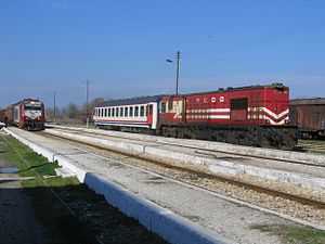
 Pythio station | |||||||||||||||||||||||||||||||||||||||||||||||||||||||||||||||||||||||||||||||||||||||||||||||||||||||||||||||||||||||||||||||||||||||||||||||||||||||||||||||||||||||||||||||||||||
| Overview | |||||||||||||||||||||||||||||||||||||||||||||||||||||||||||||||||||||||||||||||||||||||||||||||||||||||||||||||||||||||||||||||||||||||||||||||||||||||||||||||||||||||||||||||||||||
| Status | Operational up to Dikaia | ||||||||||||||||||||||||||||||||||||||||||||||||||||||||||||||||||||||||||||||||||||||||||||||||||||||||||||||||||||||||||||||||||||||||||||||||||||||||||||||||||||||||||||||||||||
| Locale |
Greece (East Macedonia and Thrace), Bulgaria (Haskovo Province) | ||||||||||||||||||||||||||||||||||||||||||||||||||||||||||||||||||||||||||||||||||||||||||||||||||||||||||||||||||||||||||||||||||||||||||||||||||||||||||||||||||||||||||||||||||||
| Termini |
Alexandroupoli Port Svilengrad 41°46′24″N 26°08′42″E / 41.7734°N 26.1451°E | ||||||||||||||||||||||||||||||||||||||||||||||||||||||||||||||||||||||||||||||||||||||||||||||||||||||||||||||||||||||||||||||||||||||||||||||||||||||||||||||||||||||||||||||||||||
| Operation | |||||||||||||||||||||||||||||||||||||||||||||||||||||||||||||||||||||||||||||||||||||||||||||||||||||||||||||||||||||||||||||||||||||||||||||||||||||||||||||||||||||||||||||||||||||
| Opening | 1874 | ||||||||||||||||||||||||||||||||||||||||||||||||||||||||||||||||||||||||||||||||||||||||||||||||||||||||||||||||||||||||||||||||||||||||||||||||||||||||||||||||||||||||||||||||||||
| Owner | OSE | ||||||||||||||||||||||||||||||||||||||||||||||||||||||||||||||||||||||||||||||||||||||||||||||||||||||||||||||||||||||||||||||||||||||||||||||||||||||||||||||||||||||||||||||||||||
| Operator(s) | TrainOSE | ||||||||||||||||||||||||||||||||||||||||||||||||||||||||||||||||||||||||||||||||||||||||||||||||||||||||||||||||||||||||||||||||||||||||||||||||||||||||||||||||||||||||||||||||||||
| Technical | |||||||||||||||||||||||||||||||||||||||||||||||||||||||||||||||||||||||||||||||||||||||||||||||||||||||||||||||||||||||||||||||||||||||||||||||||||||||||||||||||||||||||||||||||||||
| Line length | 172.5 km (107.2 mi) | ||||||||||||||||||||||||||||||||||||||||||||||||||||||||||||||||||||||||||||||||||||||||||||||||||||||||||||||||||||||||||||||||||||||||||||||||||||||||||||||||||||||||||||||||||||
| No. of tracks | single track [1] | ||||||||||||||||||||||||||||||||||||||||||||||||||||||||||||||||||||||||||||||||||||||||||||||||||||||||||||||||||||||||||||||||||||||||||||||||||||||||||||||||||||||||||||||||||||
| Track gauge | 1,435 mm (4 ft 8 1⁄2 in) standard gauge | ||||||||||||||||||||||||||||||||||||||||||||||||||||||||||||||||||||||||||||||||||||||||||||||||||||||||||||||||||||||||||||||||||||||||||||||||||||||||||||||||||||||||||||||||||||
| Electrification | no [1] | ||||||||||||||||||||||||||||||||||||||||||||||||||||||||||||||||||||||||||||||||||||||||||||||||||||||||||||||||||||||||||||||||||||||||||||||||||||||||||||||||||||||||||||||||||||
| |||||||||||||||||||||||||||||||||||||||||||||||||||||||||||||||||||||||||||||||||||||||||||||||||||||||||||||||||||||||||||||||||||||||||||||||||||||||||||||||||||||||||||||||||||||
The Alexandroupoli–Svilengrad railway is an about 172.5 km long railway connecting Alexandroupoli in Eastern Macedonia and Thrace, Greece with Svilengrad in Bulgaria, via the village of Dikaia. As of 2015 there is only passenger service on the section on Greek territory, between Alexandroupoli and Dikaia, as the international services to Sofia and Istanbul ("Friendship Express") have been suspended.
Course
The southern terminus of the Alexandroupoli–Svilengrad railway is Alexandroupoli Port, some 500m west of the main Alexandroupoli railway station. About 30 km east of Alexandroupoli the line starts following the river Evros upstream on its right bank. At Pythio, between Didymoteicho and Orestiada, the line to Istanbul branches off. It reaches Dikaia, the current terminus of all passenger services, shortly before crossing the Bulgarian border at Ormenio and joins the railway from Sofia to Istanbul in Svilengrad.
History
The section between Alexandroupoli (formerly Dedeagatch) and Svilengrad was opened in 1874 by the Chemins de fer Orientaux (CO) when the entire Thrace was part of the Ottoman Empire. The part between Pythio and Svilengrad was part of the CO main line from Istanbul to western Europe.[2] After the Treaty of Lausanne was signed in 1923 and the borders between Greece and Turkey were drawn, the line was in Greek territory with the exception of a 10 km (6.2 mi) long section from Nea Vyssa to Marasia via Karaağaç that was in Turkey. In order to get from Alexandroupoli to Dikaia, Ormenio and Svilengrad in Bulgaria, trains of the French-Hellenic Railway Company (Chemin de fer Franco-Hellenique) and later of the Hellenic State Railways would travel through Turkish territory. Trains stopped at Karaağaç, which in Greek timetables was listed as Αδριανούπολις (Adrianoupolis)/Edirne.
When the Hellenic Railways Organisation took over in 1971, they designed and constructed a 9 km (5.6 mi) direct connection between Nea Vyssa and Marasia within the Greek borders, bypassing Karaağaç and with a new intermediate station at Kastanies. The new line section, which includes a new bridge over the river Ardas, was opened in 1975 and is still in use.[3] Karaağaç railway station was abandoned and is now used as the administrative building of Trakya University.[4] The Turkish railways opened a direct line from Pehlivanköy to Svilengrad, avoiding Greek territory, in 1971.[2]
Services
As of 2015, the Alexandroupoli–Svilengrad railway is only used by three daily pairs of local trains Alexandroupoli–Dikaia[5]
References
- ↑ 1.0 1.1 OSE - 2011 Network Statement PDF
- ↑ 2.0 2.1 Trains of Turkey
- ↑ I. Zartaloudis, D. Karatolos, D. Koutelidis, G. Nathenas, S. Fasoulas, A. Filippoupolitis, A. (1997). Οι Ελληνικοί Σιδηρόδρομοι (Hellenic Railways) (in Greek). Μίλητος (Militos). p. 126. ISBN 960-8460-07-7.
- ↑ Trains of Turkey
- ↑ "2014/15 Intercity schedule". TrainOSE. Retrieved 11 March 2015.