Alentejo
| Alentejo | |
| Região do Alentejo | |
| Region, Province | |
 Typical country sight of the Alentejo. The trees in the foreground are cork oaks (Quercus suber), together with the remains of a cut wheat field. In second and third plan we can see vineyards (Vitis vinifera) and olive trees (Olea europea). Wheat, cork, olive oil and wine are the most publicized products of the Alentejo. | |
| Name origin: além-Tejo Portuguese for beyond the Tagus or across the Tagus | |
| Country | |
|---|---|
| Region | Alentejo |
| Lowest point | Sea level |
| - location | Atlantic Ocean |
| Area | 31,551.2 km2 (12,182 sq mi) |
| Population | 758,739 (2011[1]) |
| Density | 24.05 / km2 (62 / sq mi) |
| Timezone | WET (UTC+0) |
| - summer (DST) | WEST (UTC+1) |
| ISO | PT |
| NUTS | PT15 |
| GDP (nominal) | 2010 estimate |
| - Total | € 11.027 billion[2] |
| - Per capita | € 14,700[2] |
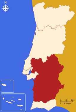 Location of the Alentejo Region in context of the national borders
| |
| Wikimedia Commons: Alentejo | |
| Website: http://www.allentejo.com/ | |
| Statistics from INE (2005); geographic detail from Instituto Geográfico Português (2010) | |
Alentejo (Portuguese pronunciation: [ɐlẽˈtɛʒu]) is the South-Central part of Portugal. The greater region is defined within Portugal by the land bordering the left bank of the Tagus river to the North and extending to the South where it borders the Algarve region. The origin of its name, "além" + "Tejo" combined as Alentejo, literally translates to "Beyond-the-Tagus" or "Across-the-Tagus".
Its main cities are Évora, Elvas, Portalegre (Upper Alentejo), Beja, Moura, Serpa (Lower Alentejo) and Sines (Coastal Alentejo).
Being a traditional region, it is also one of the more recent seven Regions of Portugal (NUTS II subdivisions). Today, Lezíria do Tejo subregion, formerly belonging to Lisboa e Vale do Tejo region, is part of Alentejo NUTS II region.
Alentejo is a region known for its traditional polyphonic singing groups, compared to those found on Sardinia, Corsica, etc.
History
The comarca of the Alentejo became the Alentejo Province, divided into upper (Alto Alentejo Province) and lower (Baixo Alentejo Province) designations. The modern region of the Alentejo was expropriated from the medieval provinces and historical territories of Estremadura Province (specifically the 1936 portions of the Ribatejo). The term "Entre-Tejo-e-Guadiana" has become obsolete; it referred to roughly the same land area between the Tagus and the Guadiana rivers part of the Kingdom of Portugal.
Geography

Topographically, the countryside varies from the open rolling plains of the south of the Alentejo to the granite hills that border Spain in the North-East. To feed the water needs of this considerable area a number of public dams have been constructed, most notably the Alqueva Dam. The landscape is primarily one of soft rolling hills and plains, with conspicuous shrubs and the native cork oaks and holly/ holm oaks, the established olive trees and grapevines, plus some naturalized eucalyptus trees and some native trees. In the North, traditional economic activity may be more livestock-based as typified by cow, sheep, and pig (both white and black) farming. To the South agriculture may be more predominant.
Biome
To the East of Portalegre one finds the Parque Natural da Serra de São Mamede, a Nature Park Area that includes charming medieval villages that may look like they have changed very little from those days. In the South near Mértola there is another Nature Park Area named Parque Natural do Vale Guadiana. This is more scarcely inhabited than the former. To the West, the coastal strip that runs from the port of Sines down to Cape St. Vincent (this already in the Algarve) comprises the Southwest Alentejo and Vicentine Coast Natural Park.
Climate
The climate of the region is typically warm and dry for a large part of the year with Summer temperatures reaching up to 40 degrees Celsius while Winters are relatively mild but wetter. Alentejo is one of the hottest places in Europe, together with the nearby Southern hinterland of Spain. In some areas of Alentejo, annual temperature averages may be as high as 25 degrees, and 50 degrees have been measured there (Amareleja, 05/07/2010). In most of the area of Alentejo, the climate is Hot-Summer Mediterranean (Csa) but there is a part, in the South of Beja District that has Semi-Arid climate, where daytime Summer temperatures may get really hot. In this part of Alentejo, Summers are even hotter than the summers in Almeria, a city in South-East Spain in an area that has an Arid desert-like climate. Most of the yearly rainfall occurs between the late Autumn and the early Spring. The largest cities in Alentejo (Beja, Évora and Portalegre) are really hot in summer with a Hot-Summer Mediterranean climate (Csa) but they are not the hottest cities, or villages in this Region. However, some studies even show that Alentejo is not the hottest place in Portugal.
Subregions
- Alentejo Central
- Alentejo Litoral
- Alto Alentejo
- Baixo Alentejo
- Lezíria do Tejo
Demographics
The resident population of the Alentejo stands at around 759,000 (fourth quarter, 2008 – 2 700 less than the fourth quarter of 2007), with 49% men and 51% women. It is the least populated region in the country, representing over one third of national territory but only 7.1% of its population. It is also the region with the oldest population, 22.9% being 65 years of age or more (while the national average is 17.5%).
The population is still declining – especially to the East of Alentejo. Locals are said to migrate from the villages to the towns and from the towns to cities beyond Alentejo. Some migration into Alentejo is from Northern Europeans looking to escape their overcrowded regions, though not always permanently, just for sunny holiday retreats.[3] People from China, Brazil, and mostly from (South-)Eastern Europe add to curbing population decline.
Education
For acceptable standards in a developed country, the illiteracy rate in the region may still be surprisingly high among those older than 60 years, in contrast with the younger generations. The rate of coverage of pre-primary education is among the highest in the country. Institutions of higher education include:
- Instituto Politécnico de Beja
- Instituto Politécnico de Portalegre
- Universidade de Évora
Economy
The area is commonly known as the "bread basket" of Portugal, a region of vast open countryside with undulating plains and rich fertile soil. With very few exceptions all the major towns are mainly reliant on agriculture, livestock and forestry. There are several types of traditional cheeses, wines and smoked hams and sausages made in the Alentejo region, among others: Queijo Serpa, Queijo de Évora and Queijo de Nisa (PDO cheeses); Vinho do Alentejo and Vinho do Redondo (wines); and presunto (smoked ham). Marble, cork, olive oil and mining industries are other important activities in the region and tourism is expected to still have growth potential. The Alqueva Dam is an important irrigation and hydroelectric power generation facility which supports a part of Alentejo's economy.
The region is the home of the world's most important area for the growing of cork. Cork-oak, known in Portugal as "sobreiro", has been grown commercially in the region for the past 300 years, with the areas between the trees typically given over to grazing, or on the more productive soils, to the growing of citrus fruit, vines or olives. As a consequence, a uniquely rich and varied eco-system has developed. The bark of the cork-oak is still harvested by teams of men using locally made hand-axes. No mechanical method has yet been invented that will allow the harvest to be achieved as effectively. The stripping of the bark is performed only in mid-Summer, when the bark can be removed more easily. The cork-oak is the only tree known that will allow this regular stripping of bark without damage. The harvest of one mature tree provides sufficient bark to produce about 4,000 wine bottle corks. The industry provides employment for about 60,000 workers.[4] In 2006, the region had an estimated GDP per inhabitant rating of 17,200 EUR.
Gallery
-

A brief view of Serpa, Alentejo
-
.jpg)
Alentejo, Portugal
-
.jpg)
Estremoz, Alentejo
-

Comporta, Alentejo
-

Casa Buralho in Cuba, Alentejo
-

Giraldo Square, Évora
-

Tróia, Portugal
-

Palácio Ducal, Vila Viçosa
-
.jpg)
Monsaraz, Portugal
-
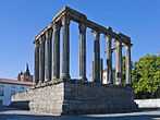
Roman Temple, in Évora
-
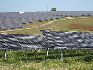
Solar power plant, Alentejo
-

Castle of Serpa, Alentejo
-

Elvas Train Station
-

Crato, Portugal
-

Santo Antão Church, Portugal
-
.jpg)
Beach in Zambujeira do Mar
-

Elvas, Portugal
See also
- Alentejo VR
References
- ↑ "Censos 2011 Resultados Preliminares 2011". INE.
- ↑ 2.0 2.1 "Regiões de Portugal". AICEP.
- ↑ "Alentejo Portugal, the essence, characteristics and places.".
- ↑ BBC, "Natural World: Cork – Forest in a Bottle", BBC2, broadcast 8.00 pm, Tuesday, 9 December 2008.
External links
| Wikimedia Commons has media related to Alentejo. |
| Wikivoyage has a travel guide for Alentejo. |
| Wikisource has the text of the 1911 Encyclopædia Britannica article Alemtejo. |
| ||||||||||||||||||||||||||||||||||||||||||||