Aldrans
| Aldrans | ||
|---|---|---|
 | ||
| ||
 Aldrans Location within Austria | ||
Location in the district
| ||
| Coordinates: 47°15′00″N 11°26′00″E / 47.25000°N 11.43333°ECoordinates: 47°15′00″N 11°26′00″E / 47.25000°N 11.43333°E | ||
| Country | Austria | |
| State | Tyrol | |
| District | Innsbruck Land | |
| Government | ||
| • Mayor | Adolf Donnemiller | |
| Area | ||
| • Total | 8.89 km2 (3.43 sq mi) | |
| Elevation | 760 m (2,490 ft) | |
| Population (1 January 2014)[1] | ||
| • Total | 2,421 | |
| • Density | 270/km2 (710/sq mi) | |
| Time zone | CET (UTC+1) | |
| • Summer (DST) | CEST (UTC+2) | |
| Postal code | 6071 | |
| Area code | 0512 | |
| Vehicle registration | IL | |
| Website | www.aldrans.at | |


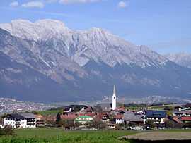
Aldrans is a municipality in the Innsbruck-Land District, Tyrol (Austria) situated at an altitude of 760 m, which had an area of 8.89 km2 and 2,183 inhabitants as January 2011.[2]
Geography
The village is placed on a highlands terrace south-eastern of Innsbruck, crossed by numerous river valleys drained, below the Patscherkofel (2246 m). Aldrans is situated on the ancient salt road, which connected Hall in Tirol and Mühlbachl, currently it’s the regional road Landesstraße L 38 (Elbögener Straße), and the southern Europe; the road L 32 (Innsbrucker Straße ) connect the village with Innsbruck, and its nearness to the city it makes a residential centre. Part of the municipal boundaries are: Prockenhöfe, Wiesenhof, Rans and Herzsee the lake, which is mainly used for fish breeding, by the characteristic shape of a heart.
Neighbour municipalities are: Ampass, Ellbögen, Igls, Innsbruck, Lans, Rinn, Sistrans.
History
Origin
The origin of Aldrans as a settlement could date back to the late Bronze Age, after the discovery of a handle of a sword and other objects of Iron Age and La Tène culture. The first mention of the village is reported in a 955 document as Alarein. In 1157 the village is mentioned in documents relating a donation, among the Counts of Andechs and the Tegernsee Abbey. In 1312, in a document, is mentioned Alrains derived from the old name of Allrainer Veld. In the Middle Ages Aldrans was part of an important market, in cooperation with Ampass, because situated on the salt road benefiting from the transit trade. In the thirteenth century the territory was divided between the Sovereign and the Abbey of Wilten.
The population was passionate of drama so much that, in 1750 and in 1757 play competitions, called Martinsspiele, were organized and it was active the "Theatre of the Amazons" which were part only women. Aldrans in the nineteenth century was developed as a summer resort and in 1884 was directly connected to Innsbruck with a road.[3]
At the edge of the village a broadcasting station was constructed in 1927. It was shut down on March 1., 1984 and afterward dismantled.
Aldrans figures in Thomas Bernhard's story Amras.
Coat-of-arms
The coat of arms represents the wings of an eagle in the air which form a lily leaf on a gold background. The wings of the eagle remember the insignia of the Counts of Andechs, and the lily leaf that of the Abbey of Tegernsee; the emblem refers to the donation that took place in 1157. The emblem was adopted November 20, 1979. [4]
Population
| Historical population | ||
|---|---|---|
| Year | Pop. | ±% |
| 1869 | 312 | — |
| 1880 | 342 | +9.6% |
| 1890 | 329 | −3.8% |
| 1900 | 325 | −1.2% |
| 1910 | 348 | +7.1% |
| 1923 | 376 | +8.0% |
| 1934 | 458 | +21.8% |
| 1939 | 555 | +21.2% |
| 1951 | 773 | +39.3% |
| 1961 | 913 | +18.1% |
| 1971 | 1,149 | +25.8% |
| 1981 | 1,477 | +28.5% |
| 1991 | 1,762 | +19.3% |
| 2001 | 1,944 | +10.3% |
| 2011 | 2,183 | +12.3% |
Main sights
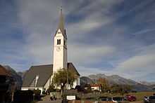
In 1365 is the citation of a church in Aldrans, in 1426 began the construction of a new church in baroque style, inaugurated in 1482 and dedicated to Saint Martin. The church was transformed in the eighteenth century in Gothic style and in 1893 was destroyed by a fire, which devastated part of the village, than was rebuilt in Gothic style. In 1965 it was enlarged and in 1967 was elevated to parish.[5]
Transportation
Aldrans is linked with Innsbruck with the Mittelgebirgsbahn (Highlands railways) Line 6 or with local buses from Innsbruck within 15 minutes.
References
- ↑ Statistik Austria - Bevölkerung zu Jahres- und Quartalsanfang, 2014-01-01.
- ↑ (German) Statistik Austria: Aldrans
- ↑ (German) Geschichte Tirol: Aldrans
- ↑ (English) Heraldry of the World: Aldrans
- ↑ (German) Geschichte Tirol: Aldrans
External links
| Wikimedia Commons has media related to Aldrans. |