Alberta Avenue, Edmonton
| Alberta Avenue | |
|---|---|
| Neighbourhood | |
|
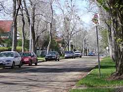
Residential street in the Alberta Avenue neighbourhood | |
|
Alberta Avenue Location of Alberta Avenue in Edmonton | |
| Coordinates: 53°34′08″N 113°29′13″W / 53.569°N 113.487°W | |
| Country |
|
| Province |
|
| City | Edmonton |
| Quadrant[1] | NW |
| Ward[1] | 7 |
| Sector[2] | Mature area |
| Government[3] | |
| • Administrative body | Edmonton City Council |
| • Councillor | Tony Caterina |
| Area[4] | |
| • Total | 1.68 km2 (0.65 sq mi) |
| Elevation | 667 m (2,188 ft) |
| Population (2012)[5] | |
| • Total | 6,176 |
| • Density | 3,676.2/km2 (9,521/sq mi) |
| • Change (2009–12) |
|
| • Dwellings | 3,390 |
Alberta Avenue is a pre–World War II neighbourhood in Edmonton, Alberta, Canada.
Alberta Avenue (formerly known as Norwood) is a mature, inner city neighbourhood in Edmonton, Alberta. Much of the area's development occurred during the First World War era and it was once home to the Great Western Garment Company and the Norwood Foundry.[6]
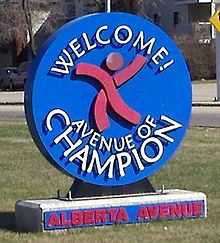 Alberta Avenue welcome sign at 101 Street |
History
Although it fell on hard times during the 1970s, Alberta Avenue is undergoing revitalization and increasingly is becoming a desirable place to live due to its close proximity to the downtown core, reasonable house prices, and access to amenities such as public transit, the Commonwealth Stadium Recreation Centre, the Sprucewood Library and many family owned restaurants and bakeries. According to a report by the City of Edmonton's Planning & Development Department, 104 building permits were issued for Alberta Avenue in 2011 with a total construction value of 5,114,708. This was the highest number of permits issued for all the mature neighbourhoods studied. Alberta Avenue was targeted in 2006 for revitalization as part of the Alberta Avenue-Eastwood Business Revitalization Zone.
In 2015, Alberta Avenue was rated #2 area in Edmonton for property investment by Avenue Magazine.[7]
The neighbourhood has an active community league and a community newspaper, the Rat Creek Press. Recently, the Rat Creek Press launched the Alberta Avenue History Project to celebrate the rich past of the community. Alberta Avenue is also home to the Carrot Coffee House, a community gathering place. Much of the revitalization efforts are supported by the non-profit organization, Arts on the Avenue and as a result, Alberta Avenue is increasingly becoming a center for Artists and arts activities in Edmonton. The Nina Haggerty Centre for the Arts is located at 9225 118 avenue and each year the community celebrates the Kaleido Family Arts Festival and the Deep Freeze Winter Festival. Live music and theater is performed at the historic Avenue Theatre located at 9030 118 Avenue.
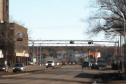 111 Avenue facing east towards Commonwealth Stadium |
Dog lovers can participate in weekly dog walking groups or the annual Avenue Goes to the Dogs Festival and others can contribute to the continued revitalization of the area by taking part in the CRUD group (Community Response to Urban Disorder).
Alberta Avenue is bounded on the north by 122 Avenue (originally called Woodward Avenue), on the west by 97 Street (originally called Namayo Avenue), on the south by 111 Avenue (Norwood Boulevard), and on the east by 89 Street (originally called Fox Street).
Demographics
In the City of Edmonton's 2012 municipal census, Alberta Avenue had a population of 6,176 living in 3,390 dwellings,[5] a -2.1% change from its 2009 population of 6,309.[8] With a land area of 1.68 km2 (0.65 sq mi),[4] it had a population density of 3,676.2 people/km2 in 2012.[5][4]
| Income By Household - 2001 Census[9][10] | ||
| Income Range ($) | Alberta Avenue[11] (% of households) |
Edmonton[12] (% of households) |
|---|---|---|
| Under $10,000 | 13.4% | 6.3% |
| $10,000-$19,999 | 17.9% | 12.4% |
| $20,000-$29,999 | 19.2% | 11.9% |
| $30,000-$39,999 | 13.1% | 11.8% |
| $40,000-$49,999 | 10.4% | 10.9% |
| $50,000-$59,999 | 6.6% | 9.5% |
| $60,000-$69,999 | 6.6% | 8.3% |
| $70,000-$79,999 | 4.9% | 6.7% |
| $80,000-$89,999 | 2.5% | 5.4% |
| $90,000-$99,999 | 0.9% | 4.2% |
| $100,000 and over | 4.5% | 12.6% |
| Average household income | $37,001 | $57,360 |
Surrounding neighbourhoods
Surrounding neighbourhoods are Delton to the north and north east, Westwood and Spruce Avenue to the west, Central McDougall to the south west, McCauley to the south and south east, and Eastwood and Parkdale to the east.
 |
Westwood | Delton | Eastwood | |
| Spruce Avenue | |
Parkdale | ||
| ||||
| | ||||
| Spruce Avenue | McCauley | Cromdale |
References
- ↑ 1.0 1.1 "City of Edmonton Wards & Standard Neighbourhoods" (PDF). City of Edmonton. Retrieved February 13, 2013.
- ↑ "Edmonton Developing and Planned Neighbourhoods, 2011" (PDF). City of Edmonton. Retrieved February 13, 2013.
- ↑ "City Councillors". City of Edmonton. Retrieved February 13, 2013.
- ↑ 4.0 4.1 4.2 "Neighbourhoods (data plus kml file)". City of Edmonton. Retrieved February 13, 2013.
- ↑ 5.0 5.1 5.2 "Municipal Census Results – Edmonton 2012 Census". City of Edmonton. Retrieved February 22, 2013.
- ↑ http://www.ratcreek.org/
- ↑ http://www.ratcreek.org/uploads/3/0/5/2/3052544/rcp_vol17_iss2_feb_2015.pdf
- ↑ "2009 Municipal Census Results". City of Edmonton. Retrieved February 22, 2013.
- ↑ 2000 dollars
- ↑ Income is for all persons in the household, ie if there are two persons in the household and each person earns $15,000, the household income is $30,000
- ↑ http://censusdocs.edmonton.ca/DD26/FEDERAL%202001/Neighbourhood/ALBERTA%20AVENUE.pdf
- ↑ http://censusdocs.edmonton.ca/DD26/FEDERAL%202001/CITY/EDMONTON.pdf
External links
- Alberta Avenue Eastwood Area Redevelopment Plan Consolidation (22 MB)
- Alberta Avenue Community League
| ||||||||||||||||||||||||||