Albeni Falls Dam
| Albeni Dam | |
|---|---|
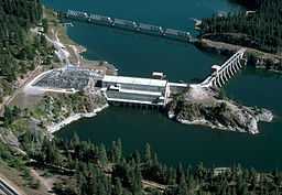 Aerial view of the reservoir and dam | |
| Location | Bonner County, Idaho |
| Coordinates | 48°10′48″N 116°59′59″W / 48.18000°N 116.99972°WCoordinates: 48°10′48″N 116°59′59″W / 48.18000°N 116.99972°W |
| Construction began | 1951[1] |
| Opening date | 1955[1] |
| Construction cost | $34 million[1] |
| Operator(s) | USACE |
| Dam and spillways | |
| Impounds | Pend Oreille |
| Height | 90 ft (27 m)[2] |
| Reservoir | |
| Creates | Raises Lake Pend Oreille |
| Power station | |
| Installed capacity | 42 mw[2] |
| Annual generation | 20,000 mw[1] |
Albeni Falls Dam is located on the Pend Oreille River between Oldtown, Idaho, and Priest River, Idaho. It is located on the site of a natural waterfall named Albeni Falls, named after early pioneer Albeni Poirier.
Construction on the dam began in 1951 and was completed in 1955 at a cost of $34 million ($261 million[3] in 2007 dollars). It produces over 200 million kilowatt hours of electricity each year for the Bonneville Power Administration and is operated by the U.S. Army Corps of Engineers.[4]
The dam is 90 feet (27 m) high and 775 feet (236 m) long. Its spillway is 400 feet (120 m) long.
See also
References
- ↑ 1.0 1.1 1.2 1.3 United States Corps of Engineers. "Albeni Falls Dam". Retrieved 2015-01-11.
- ↑ 2.0 2.1 Kalispel Natural Resource Department (2014-03-09). "Yes, It’s Happening…..Fish Passage on 6 Dams in the Pend Oreille & Clark Fork Rivers for Resident Fish". Retrieved 2015-01-09.
- ↑ Federal Reserve Bank of Minneapolis dollar worth calculator
- ↑ "Dam Information". U.S. Army Corps of Engineers. Retrieved 18 May 2011.