Albany, Minnesota
| Albany, Minnesota | |
|---|---|
| City | |
| Nickname(s): "Where Friendly Paths Cross" | |
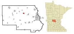 Location of Albany within Stearns County, Minnesota | |
| Coordinates: 45°38′N 94°34′W / 45.633°N 94.567°W | |
| Country | United States |
| State | Minnesota |
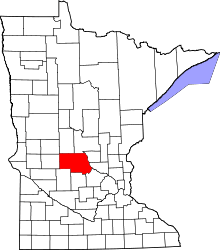
| County | Stearns |
| Government | |
| • Mayor | Daron Gersch |
| Area[1] | |
| • Total | 2.22 sq mi (5.75 km2) |
| • Land | 2.11 sq mi (5.46 km2) |
| • Water | 0.11 sq mi (0.28 km2) |
| Elevation | 1,204 ft (367 m) |
| Population (2010)[2] | |
| • Total | 2,561 |
| • Estimate (2012[3]) | 2,593 |
| • Density | 1,213.7/sq mi (468.6/km2) |
| Time zone | Central (CST) (UTC-6) |
| • Summer (DST) | CDT (UTC-5) |
| ZIP code | 56307 |
| Area code(s) | 320 |
| FIPS code | 27-00622[4] |
| GNIS feature ID | 0639241[5] |
| Website | www.ci.albany.mn.us |
Albany is a city in Stearns County, Minnesota, United States. The population was 2,561 at the 2010 census.[6] It is part of the St. Cloud Metropolitan Statistical Area.
History
The city of Albany was incorporated in 1890, but not without a struggle. The first petition to incorporate, signed by 33 residents of the proposed area of incorporation, was presented to the Stearns County Board of Commissioners on November 30, 1888. The County Board issued a notice calling for an election on the issue at the District 59 schoolhouse in January 1889.
The Great Northern and Soo Line Railroads once bounded the city, but have since been removed, and the right of way is now utilized for pedestrian, hiking, and biking travel. One of the former railway lines running from nearby St. Joseph through Albany to Sauk Centre is now a paved bike, hike, and snowmobile trail, named the Lake Wobegon Trail.
The water plant was constructed in 1902 and electricity was installed in 1909. Pine and Pelican Lakes are about 1½ and 4 miles northeast of Albany. People wonder why commercial development on Railroad Avenue, Mainstreet, was almost confined to one side of the street, as you can see in historic photos. That was no accident. The railroad designed it that way, the objective always being to receive revenue from people who used the rails. The land within the 300 foot railroad right of way was not for sale, only for lease. Businesses allowed to lease the land from the railroad were those who shipped by rail including livestock, grain, general merchandise, farm implements, automobiles, and so on. Retail merchants and service business hesitated to build on the railroad right of way with only a 30 day lease, so they built on the north side of Mainstreet. The city celebrated its centennial in 1990.[7]
Geography
According to the United States Census Bureau, the city has a total area of 2.22 square miles (5.75 km2); 2.11 square miles (5.46 km2) is land and 0.11 square miles (0.28 km2) is water.[1]
Interstate 94 and Minnesota State Highway 238 are two of the main routes in the city.
Other nearby routes include Stearns County Roads 10, 41, 54, and 157.
Demographics
| Historical population | |||
|---|---|---|---|
| Census | Pop. | %± | |
| 1900 | 517 | — | |
| 1910 | 657 | 27.1% | |
| 1920 | 824 | 25.4% | |
| 1930 | 851 | 3.3% | |
| 1940 | 975 | 14.6% | |
| 1950 | 1,196 | 22.7% | |
| 1960 | 1,375 | 15.0% | |
| 1970 | 1,599 | 16.3% | |
| 1980 | 1,569 | −1.9% | |
| 1990 | 1,548 | −1.3% | |
| 2000 | 1,796 | 16.0% | |
| 2010 | 2,561 | 42.6% | |
| U.S. Decennial Census | |||
As of 2000 the median income for a household in the city was $31,577, and the median income for a family was $41,118. Males had a median income of $31,858 versus $18,966 for females. The per capita income for the city was $16,383. About 6.0% of families and 10.3% of the population were below the poverty line, including 12.0% of those under age 18 and 14.1% of those age 65 or over.
2010 census
As of the census[2] of 2010, there were 2,561 people, 1,030 households, and 657 families residing in the city. The population density was 1,213.7 inhabitants per square mile (468.6/km2). There were 1,071 housing units at an average density of 507.6 per square mile (196.0/km2). The racial makeup of the city was 97.6% White, 0.2% African American, 0.2% Native American, 0.2% Asian, 0.7% from other races, and 1.0% from two or more races. Hispanic or Latino of any race were 0.9% of the population.
There were 1,030 households of which 36.3% had children under the age of 18 living with them, 48.4% were married couples living together, 10.6% had a female householder with no husband present, 4.8% had a male householder with no wife present, and 36.2% were non-families. 30.2% of all households were made up of individuals and 16.4% had someone living alone who was 65 years of age or older. The average household size was 2.41 and the average family size was 3.01.
The median age in the city was 33.4 years. 27.3% of residents were under the age of 18; 7.5% were between the ages of 18 and 24; 29.3% were from 25 to 44; 17.7% were from 45 to 64; and 18.2% were 65 years of age or older. The gender makeup of the city was 46.9% male and 53.1% female.
Education
The Albany Public School District, District #745, is a consolidated school district with a junior high school serving grades 7–8, and a senior high school serving grades 9–12 in eastern Albany. The Albany Elementary School serves PreK–6, and is on the same campus site as the secondary schools. Another elementary school in the district, Avon Elementary School, serves PreK–6, and is six miles east of Albany in nearby Avon. Albany Elementary and Albany Junior/Senior High both underwent major additions and renovations in 1996. The high school addition included a new lunchroom, a library, and dozens of new classrooms.
Holy Family School, a K–6 Roman Catholic parochial school, is also in Albany.
Politics
Albany is part of Minnesota House District 12B, which is represented by Paul Anderson (R); and Minnesota Senate District 12, which is represented by Torrey Westrom (R).
Albany is also part of Minnesota's 7th congressional district, currently represented in the U.S. Congress by Representative Collin Peterson (D), and Minnesota Senators Amy Klobuchar (D) and Al Franken (D).
Notable people
- James Steven Rausch – (1928–1981), Roman Catholic Bishop. Born in Albany.
References
- ↑ 1.0 1.1 "US Gazetteer files 2010". United States Census Bureau. Retrieved 2012-11-13.
- ↑ 2.0 2.1 "American FactFinder". United States Census Bureau. Retrieved 2012-11-13.
- ↑ "Population Estimates". United States Census Bureau. Retrieved 2013-05-28.
- ↑ "American FactFinder". United States Census Bureau. Retrieved 2008-01-31.
- ↑ "US Board on Geographic Names". United States Geological Survey. 2007-10-25. Retrieved 2008-01-31.
- ↑ "2010 Census Redistricting Data (Public Law 94-171) Summary File". American FactFinder. U.S. Census Bureau, 2010 Census. Retrieved 23 April 2011.
- ↑ "Albany History". Retrieved 2011-09-23.
External links
| |||||||||||||||||||||||||||||
| |||||||||||||||||||||||||||
