Al-Qastal, Jerusalem
| al-Qastal | |
|---|---|
|
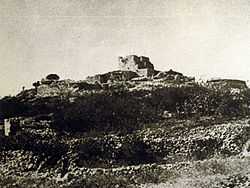
al-Qastal hill | |
 al-Qastal | |
| Arabic | القسطل |
| Name meaning | "castellum" or castale[1] |
| Subdistrict | Jerusalem |
| Coordinates | 31°47′44″N 35°8′39″E / 31.79556°N 35.14417°ECoordinates: 31°47′44″N 35°8′39″E / 31.79556°N 35.14417°E |
| Palestine grid | 163/133 |
| Area |
1,446 dunams 1.4 km² |
| Date of depopulation | April 3, 1948[2] |
| Cause(s) of depopulation | Military assault by Yishuv forces |
Al-Qastal (Arabic: القسطل) was a Palestinian village located eight kilometers west of Jerusalem named for a Crusader castle located on the hilltop. Used as a military base by the Arab Liberation Army, the village was captured by the Palmach in the lead up to the Arab-Israeli War and depopulated of its residents.
History
A Crusader castle called Belveer or Beauverium was built there around 1168 CE. It is listed amongst the castles destroyed by Sultan al-Adil I in 1191–2 CE.[3] In 1883, al-Qastal was described as "a small stone village in a conspicuous position on a rocky hill-top" with springs to the east.[4]
The 1931 census of Palestine counted 14 houses with a population of 55 Muslims and 4 Christians.[5] In 1944/45, the village, with a population of 90 Muslims, had a total of 42 dunums of land allocated to cereals. 169 dunums were irrigated or used for orchards, including 50 dunams of olive trees.[6][7]
In 1948, al-Qastal was a key position on the Jaffa-Jerusalem road and was used by Arab forces to attack Jewish relief convoys so as to prevent them from reaching the besieged Jewish parts of Jerusalem.[8] For this purpose it was occupied by the Arab Liberation Army led by Abd al-Qadir al-Husayni, the commander of the Jerusalem Hills sector.[9]

The village was assaulted by the Palmach's Harel Brigade and two squads of the Haganah during Operation Nachshon, after a previous minor clash had already caused most civilian inhabitants to flee.[6][10] Palmach troops occupied the village on April 3, but its commander was refused permission to blow up the houses.[10]

Forces under Abd al-Qadir al-Husayni attacked and besieged the Haganah-held village on 7 April, 1948. During the following, foggy night Al-Husayni himself was killed by a Haganah sentinel in a bizarre incident. On April 8, armed Arabs from the entire area, motivated by the disappearance of their leader, attacked and recaptured al-Qasta. [10] However, Al-Husayni's death is said to have led to a loss of morale among his forces.[11] Most fighters left their positions to attend al-Husayni's funeral at the Al-Aqsa Mosque on Friday, April 9. Palmach troops retook the almost fully deserted village on the night of April 8-9th; they blew up most of the houses and made the hill a command post, which they managed to hold on to.[10][12]
Mevaseret Zion is located on the former lands of Al-Qastal.[6]
See also
- Castel National Park
- List of Arab towns and villages depopulated during the 1948 Palestinian exodus
- List of villages depopulated during the Arab–Israeli conflict
References
- ↑ Palmer, 1881, p. 322
- ↑ Morris, 2004, p. xx, village #356. Also gives cause of depopulation.
- ↑ Pringle, 1997, p.118
- ↑ Conder and Kitchener, 1883, III:18. Quoted in Khalidi, 1992, p.310
- ↑ Mills, 1932, p. 32
- ↑ 6.0 6.1 6.2 Khalidi, 1992, p.311
- ↑ Hadawi, 1970, p.58, p.103
- ↑ War for the Jerusalem Road, Time, Apr. 19, 1948.
- ↑ Morris, 2008, p. 123
- ↑ 10.0 10.1 10.2 10.3 Morris, 2004, pp. 234–235.
- ↑ Morris, 2008, p. 125
- ↑ Benveniśtî, 2002, p.111.
Bibliography
- Barron, J. B., ed. (1923). Palestine: Report and General Abstracts of the Census of 1922 (PDF). Government of Palestine.
- Benvenisti, Meron (2002). Sacred Landscape: The Buried History of the Holy Land Since 1948. University of California Press. ISBN 978-0-520-23422-2.
- Conder, Claude Reignier; Kitchener, H. H. (1883). The Survey of Western Palestine: Memoirs of the Topography, Orography, Hydrography, and Archaeology 3. London: Committee of the Palestine Exploration Fund.
- Hadawi, Sami (1970). Village Statistics of 1945: A Classification of Land and Area ownership in Palestine. Palestine Liberation Organization Research Center.
- Khalidi, Walid (1992). All That Remains: The Palestinian Villages Occupied and Depopulated by Israel in 1948. Washington D.C.: Institute for Palestine Studies. ISBN 0-88728-224-5.
- Mills, E., ed. (1932). Census of Palestine 1931. Population of Villages, Towns and Administrative Areas (PDF). Jerusalem: Government of Palestine.
- Morris, Benny (2004). The Birth of the Palestinian Refugee Problem Revisited. Cambridge University Press. ISBN 978-0-521-00967-6.
- Morris, Benny (2008), 1948: A History of the First Arab-Israeli War, Yale University Press ISBN 0-300-15112-8
- Palmer, E. H. (1881). The Survey of Western Palestine: Arabic and English Name Lists Collected During the Survey by Lieutenants Conder and Kitchener, R. E. Transliterated and Explained by E.H. Palmer. Committee of the Palestine Exploration Fund.
- Pringle, Denys (1997). Secular buildings in the Crusader Kingdom of Jerusalem: an archaeological Gazetter. Cambridge University Press. ISBN 0521 46010 7.
External links
- Welcome To al-Qastal
- SWP map XVII, IAA
- SWP map 17, Wikimedia commons
- Al-Qastal from the Khalil Sakakini Cultural Center
- Al-Qastal, Palestine Family.net