Aktobe Region
| Aktobe Region Ақтөбе облысы Актюбинская область | |
|---|---|
| Region | |
|
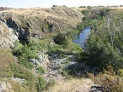
Nature in Aktobe Region | |
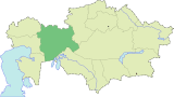
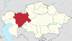 Map of Kazakhstan, location of Aktobe Province highlighted | |
| Coordinates: 50°17′N 57°10′E / 50.283°N 57.167°ECoordinates: 50°17′N 57°10′E / 50.283°N 57.167°E | |
| Country | Kazakhstan |
| Capital | Aktobe |
| Government | |
| • Akim | Arkhimed Mukhambetov |
| Area | |
| • Total | 300,629 km2 (116,074 sq mi) |
| Population (2013-02-01)[1] | |
| • Total | 797,036 |
| • Density | 2.7/km2 (6.9/sq mi) |
| Time zone | West (UTC+5) |
| • Summer (DST) | not observed (UTC+5) |
| Postal codes | 030000 |
| Area codes | +7 (713) |
| ISO 3166 code | KZ-AKT |
| Vehicle registration | 04, D |
| Districts | 12 |
| Cities | 8 |
| Villages | 441 [2] |
| Website | http://aktobe.gov.kz |
Aktobe (Kazakh: Ақтөбе облысы, Qazaq Latin Script: Aqtöbe oblısı) is a region of Kazakhstan. The Aktobe regional capital is the city of Aktobe, with a population of more than 340,000. The region itself has a population 678,900. The area of the region is 300,600 square kilometers, making it the second largest region of Kazakhstan, after Karaganda Region. Aktobe Region borders Russia to the north and Uzbekistan to the south, and also borders six other Kazakh regions: the Atyrau Region to the west, the Mangystau Region to the south-west, the Karaganda Region to the east, the Kostanay Region to the north-east, the Kyzylorda Region to the south-east, and the West Kazakhstan Region to the north-west. The Ilek River, a tributary of the Ural River, flows through the region. The name "Aktobe" comes from Kazakh "Ақ" (white) and "төбе" (hill); supposedly, Aktobe's initial settlers were able to see white mountains far to the north.
Demographics
According to the national census of 2009, the area's population was 779542 people, 407217 women and 372325 men. Kazakhs — 614961 people (79%), unlike in other areas of the country they form an overwhelming majority of the population of the area. There are a lot of Russians, Tatars, Ukrainians, Germans, Koreans, Moldavians, Jews, Armenians, Chechens and others in the area as well.
Administrative divisions
The region is administratively divided into twelve districts and the city of Aktobe.[3]
- Alga District, with the administrative center in the town of Alga;
- Ayteke Bi District, the selo of Komsomol;
- Bayganin District, the selo of Karauilkeldy;
- Kargaly District, the settlement of Badamsha;
- Khromtau District, the town of Khromtau;
- Kobda District, the aul of Kobda;
- Martuk District, the selo of Martuk;
- Mugalzhar District, the town of Kandyagash;
- Oiyl District, the selo of Oiyl;
- Shalkar District, the town of Shalkar;
- Temir District, the town of Temir;
- Yrgyz District, the selo of Yrgyz.
Eight localities in Aktobe Region have town status. These are Aktobe, Alga, Embi, Kandyagash, Khromtau, Shalkar, Temir, and Zhem. Two more localiies - Shubarkuduk and Shubarshi - have status of urban-type settlement.[4][5]
See also
References
- ↑ Agency of statistics of the Republic of Kazakhstan: Численность населения Республики Казахстан по областям с началa 2013 года до 1 февраля 2013 года (russisch; Excel-Datei; 55 kB).
- ↑ Official site - General Information
- ↑ Выбор района (in Russian). Департамент статистики Актюбинской области. Retrieved 1 June 2012.
- ↑ Население Республики Казахстан (PDF) (in Russian). Департамент социальной и демографической статистики. Retrieved 2 June 2012.
- ↑ Осадчий, Uеоргий (March 10, 2011). Город: сила притяжения (in Russian). Актюбинский вестник. Retrieved 2 June 2012.
External links
- Official Site (in Kazakh and Russian)
 |
West Kazakhstan Region | |
Kostanay Region | |
| Atyrau Region | |
Karaganda Region | ||
| ||||
| | ||||
| Mangystau Region | Karakalpakstan, |
Kyzylorda Region |
| |||||||||||||||||||||
| ||||||||||||