Aksarben Village
| Aksarben Village | |
|---|---|
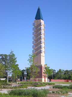
 The Obelisk in Stinson Park, part of the Aksarben Village development | |
| General information | |
| Status | Partially Complete/Under Construction |
| Location |
Omaha, Nebraska USA |
| Completed | 2008 |
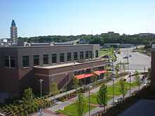
Aksarben Village is a new million sq ft mixed-use development located on the land of the old Ak-sar-ben coliseum and horse track in Midtown Omaha, Nebraska. There is over 750,000 sq ft (70,000 m2) of space for research and business office and 250,000 sq ft (23,000 m2) of retail and entertainment space. There are over 500 housing units and a 135-room hotel. There is also a 4.5-acre (1.8 ha) park that features a 90 ft (27 m) tall obelisk.[1]
History
After the Knights of Ak-Sar-Ben turned over the land to Douglas County in the 1990s, the county first tried to keep the horse track and coliseum open, but both failed. The land was then turned over to the Aksarben Future Trust who now owns the land.[2] On June 26, 2005, plans were announced to turn the land into a pedestrian friendly mixed-use development combined with the south campus of University of Nebraska Omaha, Aksarben Campus, and the already built First Data Campus. Construction began in 2006 and the first businesses began to open in 2008.[3] Aksarben is Nebraska spelled backwards.
Developments
Aksarben Village is home to some of Omaha's major companies. Blue Cross Blue Shield of Nebraska has built and is occupying a 10-story building that opened in 2010 to house their headquarters.[4] First Data built two office buildings there in the mid-2000s. Other business that have opened offices include DLR Group, Grubb & Ellis/Pacific Realty, and Olsson Associates.

Several restaurants such as Jones Bros. Cupcakes,[5] Godfather's Pizza and Juice Stop have opened, as well as a bank, a neighborhood grocer called Wohlner's, a hair salon, and multiple bars and lounges. Two apartment complexes have opened, Broadmoor[6] and the Pinhook Flats,[7] named in reference to the historic horse track which used to occupy the land. Together the apartments add over 500 housing units to the development. A 135-room Marriott Hotel opened in 2008. In December 2010, Aksarben Cinema,[8] a 10-screen movie theater opened and shortly after an Aspen Athletic Club[9] fitness center opened in the same complex. Mojo Steakhouse and Ales, a full-service restaurant and bar will open in late spring of 2011 in the same complex.
The University of Nebraska Omaha has built their south campus, Aksarben Campus, at the north end of Aksarben Village. The university has added 10, three story dormitory buildings, Scott Village, which opened in 2003 and houses 480 units.[10] The Scott Technology Center[11] and The Peter Kiewit Institute[12] are world class educational and research facilities that partner with UNO and are located on campus. The university is currently building a new sports arena, tentatively known as UNO Community Arena, at the south end of Aksarben Village. The venue is scheduled to open in fall 2015.[13]
Within Aksarben Village, Stinson park, a multi-acre neighborhood and community park has been built named after former Knights of Aksarben chairman Kenneth E. Stinson.[14]
References
- ↑
- ↑ http://www.aksarbenvillage.com/history/default.aspx
- ↑
- ↑
- ↑ "Jones Bros. Cupcakes". Archived from the original on 8 February 2011. Retrieved 2011-02-11.
- ↑ "Welcome Home! - Broadmoor at Aksarben Village Apartments". Aksarbenapts.com. Retrieved 2010-09-08.
- ↑ "Grounds of Glory". Pinhook Flats. Retrieved 2010-09-08.
- ↑ "Aksarben Cinema". Retrieved 2011-02-11.
- ↑ "Aspen Athletic Clubs". Retrieved 2011-02-11.
- ↑ "UNO Alumni". Scott Village. Retrieved 2010-09-08.
- ↑ "Scott Technology Center". Scott-technology.com. 2010-06-25. Retrieved 2010-09-08.
- ↑ "The Peter Kiewit Institute". Pki.nebraska.edu. 2009-03-31. Archived from the original on 22 September 2010. Retrieved 2010-09-08.
- ↑ Burbach, Christopher (October 6, 2014). "UNO's rising arena, finances both solid". Omaha World-Herald. Retrieved February 17, 2015.
- ↑ "Kenneth E. Stinson". Nndb.com. Archived from the original on 10 October 2010. Retrieved 2010-09-08.
External links
Coordinates: 41°14′17″N 96°00′53″W / 41.23806°N 96.01472°W