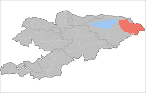
Ak-Suu District
| Ak-Suu | |
|---|---|
| Raion | |
 | |
| Country | Kyrgyzstan |
| Province | Issyk Kul Province |
| Area | |
| • Total | 3,829 sq mi (9,917 km2) |
| Population (2009)[1] | |
| • Total | 62,524 |
| enumerated de facto population | |
| Time zone | GMT +6 (UTC+6) |
Ak-Suu is a raion (district) of Issyk Kul Province in eastern Kyrgyzstan. The administrative center lies at the village Teploklyuchenka.[2]
Geography
Located in Kyrgyzstan's eastern corner, the district borders in the north with the Almaty Province of Kazakhstan, and in the east, with the Aksu Prefecture of China's Xinjiang Uyghur Autonomous Region. Two of Kyrgyzstan's highest mountains, Jengish Chokusu (Victory Peak, or Pobeda Peak in Russian) and Khan Tengri, are located on these borders.
Demographics
In total, in 2009 the Ak-Suu District included 1 urban-type settlement and 38 villages in 13 rural communities (aiyl okmotus). Its population, according to the Population and Housing Census of 2009, was 62,524. The average density was 6.3 people per square kilometer.
| Historical populations in Ak-Suu District | ||
|---|---|---|
| Year | Pop. | ±% |
| 1970 | 44,046 | — |
| 1979 | 50,236 | +14.1% |
| 1989 | 57,109 | +13.7% |
| 1999 | 57,160 | +0.1% |
| 2009 | 62,524 | +9.4% |
| Note: enumerated de facto population; Source:[1] | ||
Ethnic composition
According to the 2009 Census, the ethnic composition (de jure population) of the Ak-Suu District was:[1]
| Ethnic group | Population | Proportion of Ak-Suu District population |
|---|---|---|
| Kyrgyzs | 56,369 | 88.5% |
| Russians | 2,884 | 4.5% |
| Kalmyks | 2,805 | 4.4% |
| Kazakhs | 916 | 1.5% |
| Uygurs | 201 | 0.3% |
| Tatars | 146 | 0.2% |
| Ukrainians | 125 | 0.2% |
| Uzbeks | 110 | 0.2% |
| other groups | 130 | 0.2% |
Populated areas
The urban-type settlements, rural communities and villages in the Ak-Suu District are:[1]
- urban-type settlement Jyrgalan
- Ak-Bulun aiyl okmotu (center village Ak-Bulun, and also villages Ak-Bulak and Toktogul)
- Beryu-Bash aiyl okmotu (center - village Beryu-Bash, and also village Cherik)
- Kara-Jal aiyl okmotu (center - village Tegizchil, and also villages Jany-Aryk, Kara-Jal, Boz-Bulun)
- Karakol aiyl okmotu (center - village Karakol, and also village Cholpon)
- Kerege-Tash aiyl okmotu (center - village Sary-Kamysh, and also villages Kerege-Tash, Kayyrma-Aryk, Novokonstantinovka, Pioner)
- Novovoznesenovka aiyl okmotu (center - village Novovoznesenovka, and also villages Boz-Uchuk and Ichke-Jergez)
- Oktyabrskiy aiyl okmotu (center - village Oktyabrskoye, and also villages Jol-Kolot, Otuz-Uul, Uch-Kaynar)
- Otradnoye aiyl okmotu (center - village Otradnoye, and also villages Orlinoye, Shapak)
- Ak-Chiy aiyl okmotu (center - village Ak-Chiy, and also villages Kachybek, Sovetskoye)
- Tepke aiyl okmotu (center - village Tepke, and also villages Jyldyz, Kurbu)
- Teploklyuchenka aiyl okmotu (center - village Teploklyuchenka, and also village Lesnoye)
- Chelpek aiyl okmotu (center - village Chelpek, and also villages Burma-Suu, Tash-Kyya)
- Engilchek aiyl okmotu (center - village Engilchek)
References
- ↑ 1.0 1.1 1.2 1.3 Population and Housing Census 2009. Book 3 (in tables). Provinces of Kyrgyzstan: Issyk-Kul Province (Перепись населения и жилищного фонда Кыргызской Республики 2009. Книга 3 (в таблицах). Регионы Кыргызстана: Иссык-Кульская область (PDF), Bishkek: National Committee on Statistics, 2010
- ↑
| |||||||||||||||||||||||||||||||||||||
