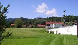
Ainring
| Ainring | ||
|---|---|---|
 | ||
| ||
 Ainring | ||
Location of Ainring within Berchtesgadener Land district 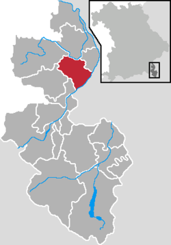 | ||
| Coordinates: 47°48′49″N 12°56′34″E / 47.81361°N 12.94278°ECoordinates: 47°48′49″N 12°56′34″E / 47.81361°N 12.94278°E | ||
| Country | Germany | |
| State | Bavaria | |
| Admin. region | Oberbayern | |
| District | Berchtesgadener Land | |
| Government | ||
| • Mayor | Hans Eschlberger (CSU) | |
| Area | ||
| • Total | 32.97 km2 (12.73 sq mi) | |
| Population (2013-12-31)[1] | ||
| • Total | 9,598 | |
| • Density | 290/km2 (750/sq mi) | |
| Time zone | CET/CEST (UTC+1/+2) | |
| Postal codes | 83404 | |
| Dialling codes | 08654 & 08656 | |
| Vehicle registration | BGL | |
| Website | www.ainring.de | |

Ainring is a municipality in the district of Berchtesgadener Land, Upper Bavaria, Germany, near the border to Austria.
After WW II it was the site of a displaced persons camp.[2]
References
- ↑ "Fortschreibung des Bevölkerungsstandes". Bayerisches Landesamt für Statistik und Datenverarbeitung (in German). 31 December 2013.
- ↑ Wyman, Mark (1998). Dps: Europe's Displaced Persons, 1945-1951. Cornell paperbacks. p. 116. ISBN 9780801485428. Retrieved December 27, 2012.
| ||||||||
| Wikimedia Commons has media related to Ainring. |