Aiguille de la Tsa
| Aiguille de la Tsa | |
|---|---|
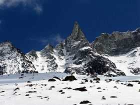 Aiguille de la Tsa from the west side | |
| Elevation | 3,668 m (12,034 ft) |
| Prominence | 251 m (823 ft)[1] |
| Parent peak | Dent de Perroc |
| Location | |
 Aiguille de la Tsa Location in Switzerland | |
| Location | Valais, Switzerland |
| Range | Pennine Alps |
| Coordinates | 46°01′17″N 07°31′20″E / 46.02139°N 7.52222°ECoordinates: 46°01′17″N 07°31′20″E / 46.02139°N 7.52222°E |
The Aiguille de la Tsa is a mountain of the Swiss Pennine Alps, overlooking Arolla in the canton of Valais. It lies on the range culminating at the Dent de Perroc, between the valley of Arolla and the Mont Miné Glacier.
References
- ↑ Retrieved from the Swisstopo topographic maps. The key col is located south of the Pointe des Genevois at 3,417 metres.
External links
![]() Media related to Aiguille de la Tsa at Wikimedia Commons
Media related to Aiguille de la Tsa at Wikimedia Commons