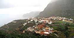
Agulo
Agulo is located on the north coast of the island of La Gomera in the province of Santa Cruz de Tenerife of the Canary Islands. It is located 13 km northwest of the capital San Sebastián de la Gomera. The population was 1,100 in 2013.[2]
Geography
The main crop is bananas. Agulo is known as the "green balcony". The Meriga Forest is part of UNESCO's World Heritage Site, and is part of the Garajonay National Park. A site of interest is Torta de Cuajada.
Subdivisions
- Agulo
- Lepe
- La Palmita
- Las Rosas
- Cruz de Tierno
- Juego de Bolas
- Meriga
- Pajar de Bento
- Piedra Gorda
- Serpa
- La Vega
See also
References
Sources
- Brown, A. Samler. Madeira Canary Islands and Azores. (London, S.E.: Sampson Low, Marston & Co., Limited, 1908).
External links
 |
Wikimedia Commons has media related to Agulo. |
.svg.png)