Aguilar, Pangasinan
| Aguilar | ||
|---|---|---|
| Municipality | ||
|
| ||
| ||
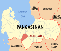
 Map of Pangasinan showing the location of Aguilar | ||
.svg.png) Aguilar Location within the Philippines | ||
| Coordinates: 15°50′N 120°12′E / 15.833°N 120.200°ECoordinates: 15°50′N 120°12′E / 15.833°N 120.200°E | ||
| Country |
| |
| Region | Ilocos (Region I) | |
| Province | Pangasinan | |
| District | 2nd district of Pangasinan | |
| Founded | 1805 | |
| Barangays | 16 | |
| Government[1] | ||
| • Mayor | Eduardo T. Ballesteros (Lakas–CMD) | |
| • Vice Mayor | Roldan Caoile Sagles | |
| Area[2] | ||
| • Total | 195.07 km2 (75.32 sq mi) | |
| Population (2010)[3] | ||
| • Total | 39,529 | |
| • Density | 200/km2 (520/sq mi) | |
| Time zone | PST (UTC+8) | |
| ZIP code | 2415 | |
| Dialing code | 75 | |
| Income class | 3rd class; rural | |
Aguilar is a third class municipality in the province of Pangasinan, Philippines. According to the 2010 census, it has a population of 39,529 people.[3] The municipality got its name after Spanish governor-general Rafael Maria de Aguilar.
The Hall of Justice is located at the second floor of the Town Hall where the Municipal Circuit Trial Court of Aguilar and San Jacinto is located.
History
Aguilar was founded as a municipality in July 16, 1805, through a decree issued by Governor General Rafael Maria de Aguilar whom this town was named after. Local folklores likewise maintained that Aguilar was identified with an eagle or agila that used to fly around the place at nighttime and would perch on a fence or alar when tired of flying, hence, agila and alar put together formed AGUILAR.[4]
Barangays
Aguilar is politically subdivided into 16 barangays.[2]
- Bayaoas
- Baybay
- Bocacliw
- Bocboc East
- Bocboc West
- Buer
- Calsib
- Niñoy
- Poblacion
- Pogomboa
- Pogonsili
- San Jose
- Tampac
- Laoag
- Manlocboc
- Panacol
Demographics
| Population Census of Aguilar | ||
|---|---|---|
| Year | Pop. | ±% p.a. |
| 1990 | 27,303 | — |
| 1995 | 30,578 | +2.15% |
| 2000 | 33,213 | +1.79% |
| 2007 | 36,564 | +1.33% |
| 2010 | 39,529 | +2.88% |
| Source: National Statistics Office[3][5] | ||
Economy
Because of the majority of vast farmlands in Aguilar, The Major Crops planted in Aguilar are Rice, Corn, Vegetables, Mangoes, Luffas and other crops. Aguilar is also engages in Poultry and Livestock Raising including Cows, Pigs, Carabaos, Goats, Chickens and Domestic Ducks.
Points of interest
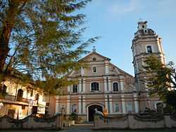
There are many Tourist Spots in Aguilar some of them are: St. Joseph The Patriarch Church and Mt. Nambersian. Hikers can climb to the summit of Mount Nambersian in Barangay Niñoy, Aguilar, Pangasinan one of the famous mountains in Aguilar. You can go to St. Joseph The Patriarch Church. It was built during 1810 by the help of friars to build the first church in Aguilar. It was named after the Patron Saint of the town and celebrated every March 18 the town's fiesta
-

Facade
-
Bell tower
-
Parish Rectory side facade
-
Interior
Educational institutions
High Schools:
- Bocboc East National High School
- Don G. Dumlao National High School
- Enrico T. Prado National High School
- Tampac Integrated School
Elementary Schools:
- Aguilar Central School
- Anonang Elementary School
- Baybay Elementary School
- Bocacliw Elementary School
- Bocboc East Elementary School
- Bocboc West Elementary School
- Buer-Bayaoas Elementary School
- Caslib Elementary School
- Casagatan Elementary School
- Dona Catalina Elementary School
- Manlocboc Elementary School
- Mapita Elementary School
- Ninoy Elementary School
- Pogonsili Elementary School
- Panacol Elementary School
- Sipitan Elementary School
- Tampac Elementary School
Private Schools:
- Aguilar Catholic School
- Aguilar Holy Infant Educ'l. Ctr, Inc.
- Aguilar Learning Center
- The Maranatha Baptist Academy
- Zaratan Rural Institute, Inc.
Gallery
-
Rizal Monument and the Covered Court
-
Covered Court
-
Aguilar Catholic School, Inc.
-
Public Market and stores
-
Don Francisco Q. Duque Freedom Park
-
Aguilar Hospital
References
- ↑ "Official City/Municipal 2013 Election Results". Intramuros, Manila, Philippines: Commission on Elections (COMELEC). 1 July 2013. Retrieved 3 September 2013.
- ↑ 2.0 2.1 "Province: PANGASINAN". PSGC Interactive. Makati City, Philippines: National Statistical Coordination Board. Retrieved 26 November 2012.
- ↑ 3.0 3.1 3.2 "Total Population by Province, City, Municipality and Barangay: as of May 1, 2010". 2010 Census of Population and Housing. National Statistics Office. Retrieved 26 November 2012.
- ↑ Aguilar. The Official Website of the Province of Pangasinan and its People. Retrieved April 9, 2012
- ↑ "Province of Pangasinan". Municipality Population Data. LWUA Research Division. Retrieved 3 September 2013.
External links
| Wikimedia Commons has media related to Aguilar, Pangasinan. |
- Philippine Standard Geographic Code
- Philippine Census Information
- Local Governance Performance Management System
 |
Bugallon | San Carlos |  | |
| Bugallon | |
Mangatarem | ||
| ||||
| | ||||
| Santa Cruz, Zambales | Mangatarem |
| ||||||||||||||||||||||


