Agui, Aichi
| Agui 阿久比町 | |||
|---|---|---|---|
| Town | |||
|
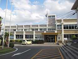
Agui Town Hall | |||
| |||
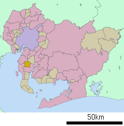 Location of Agui in Aichi Prefecture | |||
 Agui
| |||
| Coordinates: 34°56′N 136°55′E / 34.933°N 136.917°ECoordinates: 34°56′N 136°55′E / 34.933°N 136.917°E | |||
| Country | Japan | ||
| Region |
Chūbu region Tōkai region | ||
| Prefecture | Aichi Prefecture | ||
| District | Chita | ||
| Area | |||
| • Total | 23.94 km2 (9.24 sq mi) | ||
| Population (October 2011) | |||
| • Total | 26,149 | ||
| • Density | 1,090/km2 (2,800/sq mi) | ||
| Time zone | Japan Standard Time (UTC+9) | ||
| - Tree | Ilex integra | ||
| - Flower | Prunus mume | ||
| Phone number | 0569-48-1111 | ||
| Address | Agui-chō, Chita-gun, Aichi-ken 470-2292 | ||
| Website | Town of Agui HP | ||


Agui (阿久比町 Agui-chō) is a town located in Chita District, Aichi Prefecture, Japan. As of 2011, the town had an estimated population of 26,149 and a population density of 1090 persons per km². The total area was 23.94 km².[1]
Geography
Agui is located in northwestern Chita Peninsula in southern Aichi Prefecture.
Neighboring municipalities
History
The name of Agui is very ancient, and appears in Nara period records. During the Muromachi period, the area was the territory of the Hisamasu clan, and later came under the control of Oda Nobunaga. The modern village of Agui was founded in October 1889, and became a town on January 1, 1953.
Economy
Agui is largely an agricultural center, and is bedroom community for the city of Nagoya.
Transportation
Railway
Highway
Agui is not served by any national highways
References
- ↑ 阿久比町はこんなまちです. Agui official website (in Japanese). Retrieved 9 August 2011.
External links
![]() Media related to Agui, Aichi at Wikimedia Commons
Media related to Agui, Aichi at Wikimedia Commons
- Official website (Japanese)
| ||||||||||||||||||||||||||||||||||||||||