Agassiz Peak
| Agassiz Peak | |
|---|---|
 Agassiz Peak | |
| Elevation | 12,360 ft (3,770 m) NAVD 88[1] |
| Prominence | 556 ft (169 m)[1] |
| Location | |
 Agassiz Peak | |
| Range | San Francisco Peaks |
| Coordinates | 35°19′33″N 111°40′41″W / 35.3258419°N 111.677939°WCoordinates: 35°19′33″N 111°40′41″W / 35.3258419°N 111.677939°W[2] |
| Topo map | USGS Humphreys Peak |
| Climbing | |
| Easiest route | Hike (see below for closed season) |
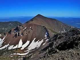
Agassiz Peak is the second-highest mountain in the U.S. state of Arizona at 12,360 feet (3,767 m). It is located in the San Francisco Peaks in the Coconino National Forest north of Flagstaff, Arizona. The peak was named for Louis Agassiz, the celebrated naturalist.[2]
Many visitors to Flagstaff incorrectly assume that Agassiz Peak is Humphreys Peak, the state high point. This is because Agassiz is between Humphreys and Flagstaff, blocking the view of Humphreys from town.
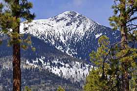
The mountain is only open to climbers in the winter when it is covered in snow. Hiking above treeline at other times is illegal due to the "threatened with critical habitat" status of the San Francisco Peaks groundsel (Senecio franciscanus).[3]
At a latitude of 35.3258419° N, Agassiz Peak is the southernmost mountain peak in the contiguous United States which rises to a height of more than 12,000 feet above sea level.
See also
References
- ↑ 1.0 1.1 "Agassiz Peak, Arizona". Peakbagger.com. Retrieved 2009-01-09.
- ↑ 2.0 2.1 "Agassiz Peak". Geographic Names Information System. United States Geological Survey. Retrieved 2009-01-09.
- ↑ "Agassiz Peak". SummitPost.org. Retrieved 2009-01-09.
| Wikimedia Commons has media related to San Francisco Peaks . |